TopoQuest Logo
Do you find TopoQuest useful?
Help keep TopoQuest running and adding new maps/features by donating!
Bitcoin:  19c7KJd3qBynnjoSw5npx9KScwjBe4ifkT
Litecoin:  LXs6TkuXGGXo1vDsWCkWVdjQX94eUKd6ui
Home View Maps Find Maps Find Places Resources & Links


Climax Springs, Missouri Topographic Map

USGS Map Title: Climax Springs, MO
USGS Map MRC: 38093A1
DRG (GeoTIFF) Download: o38093a1.tif


Neighboring USGS Topographic Map Quads:


  Edwards, MO  
38093B2
 

  Knobby, MO  
38093B1
 

  Bollinger Creek, MO  
38092B8
 

  Cross Timbers, MO  
38093A2
 

  Climax Springs, MO  
38093A1
 

  Barnumton, MO  
38092A8
 

  Preston, MO  
37093H2
 

  Branch, MO  
37093H1
 

  Macks Creek, MO  
37092H8


Map MRC Location:

N39°
W94°
N39°
W93°
H8 H7 H6 H5 H4 H3 H2 H1
G8 G7 G6 G5 G4 G3 G2 G1
F8 F7 F6 F5 F4 F3 F2 F1
E8 E7 E6 E5 E4 E3 E2 E1
D8 D7 D6 D5 D4 D3 D2 D1
C8 C7 C6 C5 C4 C3 C2 C1
B8 B7 B6 B5 B4 B3 B2 B1
A8 A7 A6 A5 A4 A3 A2 A1
N38°
W94°
N38°
W93°

Climax Springs, MO USGS 1:24K Topographic Map Preview:
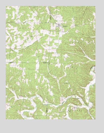
Climax Springs, MO USGS Topographic Map
Click on map above to begin viewing in our Map Viewer.

This topographic map contains these locations and features:
Feature Name Type Latitude Longitude GNIS ID View Map
Carlson Lake DamDamN38.0650°W93.1235°765426View Map
Childers (historical)LocaleN38.0592°W93.1177°744857View Map
Climax SpringsPopulated PlaceN38.1042°W93.0502°755543View Map
Climax Springs CemeteryCemeteryN38.1067°W93.0635°715991View Map
Climax Springs Census Designated PlaceCensusN38.1004°W93.0528°2784076View Map
Climax Springs Lookout TowerTowerN38.1034°W93.0294°755032View Map
Climax Springs Post OfficePost OfficeN38.0970°W93.0525°2783205View Map
Coffee HollowValleyN38.0109°W93.0091°716068View Map
Creach CemeteryCemeteryN38.0086°W93.0371°716480View Map
Flint Springs School (historical)SchoolN38.0073°W93.0849°745328View Map
Green CemeteryCemeteryN38.0153°W93.0113°718782View Map
Green Ridge ChurchChurchN38.0398°W93.0380°718806View Map
Harmony ChurchChurchN38.0131°W93.0296°719111View Map
High Point School (historical)SchoolN38.0125°W93.0271°745256View Map
Macks CreekStreamN38.0159°W93.0132°721733View Map
Miller AirportAirportN38.1167°W93.0750°758640View Map
Mulberry School (historical)SchoolN38.0475°W93.1033°745327View Map
Northwest Fire Protection District Station 1 HeadquartersBuildingN38.0952°W93.0443°2620770View Map
Pennel BranchStreamN38.0067°W93.0385°724205View Map
Phillips BranchStreamN38.0195°W93.0424°724289View Map
Starks CreekStreamN38.0228°W93.0899°727034View Map
Township of JordanCivilN38.0266°W93.1215°766755View Map
Village of Climax Springs (historical)CivilN38.1016°W93.0541°2398581View Map
Wiseman ChurchChurchN38.0920°W93.0905°729833View Map

Note: Coordinates in the location and feature list above are referenced to NAD83 datum.


Copyright (C) 2008-2025 Ryan Niemi / Sunset Dynamics ... All Rights Reserved