TopoQuest Logo
Do you find TopoQuest useful?
Help keep TopoQuest running and adding new maps/features by donating!
Bitcoin:  19c7KJd3qBynnjoSw5npx9KScwjBe4ifkT
Litecoin:  LXs6TkuXGGXo1vDsWCkWVdjQX94eUKd6ui
Home View Maps Find Maps Find Places Resources & Links


Warrens East, Wisconsin Topographic Map

USGS Map Title: Warrens East, WI
USGS Map MRC: 44090B4
DRG (GeoTIFF) Download: o44090b4.tif


Neighboring USGS Topographic Map Quads:


  Hatfield SE, WI  
44090C5
 

  Spaulding, WI  
44090C4
 

  City Point, WI  
44090C3
 

  Warrens West, WI  
44090B5
 

  Warrens East, WI  
44090B4
 

  Mather, WI  
44090B3
 

  Tunnel City, WI  
44090A5
 

  Wyeville, WI  
44090A4
 

  Shennington, WI  
44090A3


Map MRC Location:

N45°
W91°
N45°
W90°
H8 H7 H6 H5 H4 H3 H2 H1
G8 G7 G6 G5 G4 G3 G2 G1
F8 F7 F6 F5 F4 F3 F2 F1
E8 E7 E6 E5 E4 E3 E2 E1
D8 D7 D6 D5 D4 D3 D2 D1
C8 C7 C6 C5 C4 C3 C2 C1
B8 B7 B6 B5 B4 B3 B2 B1
A8 A7 A6 A5 A4 A3 A2 A1
N44°
W91°
N44°
W90°

Warrens East, WI USGS 1:24K Topographic Map Preview:
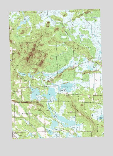
Warrens East, WI USGS Topographic Map
Click on map above to begin viewing in our Map Viewer.

This topographic map contains these locations and features:
Feature Name Type Latitude Longitude GNIS ID View Map
5.46 ReservoirReservoirN44.1292°W90.4756°1793628View Map
Apple CreekStreamN44.1311°W90.4762°1560903View Map
Ball BluffSummitN44.1986°W90.4582°1561129View Map
Bear Bluff StationLocaleN44.2333°W90.4265°1561343View Map
Beltz CreekStreamN44.1441°W90.4846°1561550View Map
Goodyear DitchCanalN44.2464°W90.4179°1565639View Map
Goodyear LakeLakeN44.2240°W90.4019°1565640View Map
Hunters PeakSummitN44.2466°W90.3949°1566816View Map
Hunters Peak DitchCanalN44.2430°W90.3990°1566817View Map
Jensen DamDamN44.1300°W90.4735°1793627View Map
Lake 1 8 Upper Reservoir 17.41ReservoirN44.1555°W90.4489°1793624View Map
Lake 7-8 22ReservoirN44.1415°W90.4284°1792918View Map
Lake 7-9 22ReservoirN44.1372°W90.4256°1792920View Map
Miles PeakSummitN44.2158°W90.4851°1569459View Map
North Scott Township DamDamN44.1416°W90.3785°1792704View Map
Potter DamDamN44.1383°W90.4218°1792917View Map
Potter DamDamN44.1366°W90.4251°1792919View Map
Sawdust MarshLakeN44.1875°W90.4839°1573748View Map
Scott FlowageReservoirN44.1437°W90.3784°1573840View Map
Stanley HillRidgeN44.1555°W90.4157°1574791View Map
Strozewski DamDamN44.1550°W90.4468°1793623View Map
Taylor IslandIslandN44.1886°W90.3901°1575274View Map
Town of KnappCivilN44.2486°W90.4963°1583488View Map
WarrensPopulated PlaceN44.1311°W90.4999°1576222View Map
Warrens Police DepartmentBuildingN44.1307°W90.4974°2759936View Map
Winkler HillsRangeN44.2075°W90.4726°1576867View Map

Note: Coordinates in the location and feature list above are referenced to NAD83 datum.


Copyright (C) 2008-2024 Ryan Niemi / Sunset Dynamics ... All Rights Reserved