TopoQuest Logo
Do you find TopoQuest useful?
Help keep TopoQuest running and adding new maps/features by donating!
Bitcoin:  19c7KJd3qBynnjoSw5npx9KScwjBe4ifkT
Litecoin:  LXs6TkuXGGXo1vDsWCkWVdjQX94eUKd6ui
Home View Maps Find Maps Find Places Resources & Links


Warrens West, Wisconsin Topographic Map

USGS Map Title: Warrens West, WI
USGS Map MRC: 44090B5
DRG (GeoTIFF) Download: o44090b5.tif


Neighboring USGS Topographic Map Quads:


  Hatfield SW, WI  
44090C6
 

  Hatfield SE, WI  
44090C5
 

  Spaulding, WI  
44090C4
 

  Millston, WI  
44090B6
 

  Warrens West, WI  
44090B5
 

  Warrens East, WI  
44090B4
 

  Alderwood Lake, WI  
44090A6
 

  Tunnel City, WI  
44090A5
 

  Wyeville, WI  
44090A4


Map MRC Location:

N45°
W91°
N45°
W90°
H8 H7 H6 H5 H4 H3 H2 H1
G8 G7 G6 G5 G4 G3 G2 G1
F8 F7 F6 F5 F4 F3 F2 F1
E8 E7 E6 E5 E4 E3 E2 E1
D8 D7 D6 D5 D4 D3 D2 D1
C8 C7 C6 C5 C4 C3 C2 C1
B8 B7 B6 B5 B4 B3 B2 B1
A8 A7 A6 A5 A4 A3 A2 A1
N44°
W91°
N44°
W90°

Warrens West, WI USGS 1:24K Topographic Map Preview:
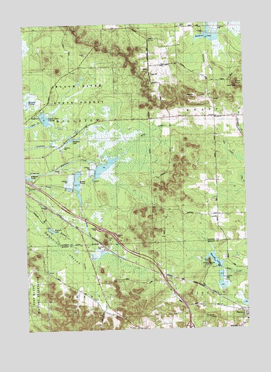
Warrens West, WI USGS Topographic Map
Click on map above to begin viewing in our Map Viewer.

This topographic map contains these locations and features:
Feature Name Type Latitude Longitude GNIS ID View Map
Castle RockSummitN44.1525°W90.5215°1562792View Map
Drescher SchoolSchoolN44.2116°W90.5162°1564102View Map
Harkner 1 DamDamN44.1900°W90.5851°1791928View Map
Harkner 2 DamDamN44.1900°W90.5868°1793395View Map
Harkner FlowageLakeN44.1846°W90.5954°1845457View Map
Hawkins LakeLakeN44.2441°W90.5196°1845459View Map
Jay Creek Pine Forest State Natural AreaParkN44.1805°W90.5015°2062798View Map
Ketchum Creek Pines State Natural AreaParkN44.2180°W90.5735°2062800View Map
Ketchum LakeReservoirN44.2030°W90.5981°1845472View Map
Knapp CemeteryCemeteryN44.2291°W90.5526°1845474View Map
Knapp MoundSummitN44.2236°W90.5040°1567564View Map
Lake 23 15 6ReservoirN44.1917°W90.5797°1791929View Map
Lake 27-1 6ReservoirN44.1894°W90.5855°1793396View Map
McMullen Memorial County ParkParkN44.1516°W90.5207°1846243View Map
Oakdale SchoolSchoolN44.2319°W90.5543°1570696View Map
Paradise SchoolSchoolN44.1333°W90.5837°1571024View Map
Paradise ValleyValleyN44.1813°W90.6237°1571025View Map
Pigeon Creek FlowageReservoirN44.2116°W90.6135°1793157View Map
Resettlement Administration 23 DamDamN44.2100°W90.6151°1793156View Map
Robinson PondLakeN44.1881°W90.6241°1845499View Map
Rudd CreekStreamN44.1780°W90.5946°1572711View Map
Rudd HillsSummitN44.1605°W90.5807°1572712View Map
Saint Lukes ChurchChurchN44.2114°W90.5165°1845507View Map
Town of Lincoln Fire DepartmentBuildingN44.1275°W90.5030°2697714View Map
Town of MillstonCivilN44.2482°W90.6162°1583717View Map
Village of WarrensCivilN44.1296°W90.5025°1584347View Map
Warrens Elementary SchoolSchoolN44.1284°W90.5010°1846319View Map
Wazeda LakeReservoirN44.1528°W90.5181°1577275View Map
Wyman LakeReservoirN44.1660°W90.6106°1577064View Map

Note: Coordinates in the location and feature list above are referenced to NAD83 datum.


Copyright (C) 2008-2024 Ryan Niemi / Sunset Dynamics ... All Rights Reserved