TopoQuest Logo
Do you find TopoQuest useful?
Help keep TopoQuest running and adding new maps/features by donating!
Bitcoin:  19c7KJd3qBynnjoSw5npx9KScwjBe4ifkT
Litecoin:  LXs6TkuXGGXo1vDsWCkWVdjQX94eUKd6ui
Home View Maps Find Maps Find Places Resources & Links


Wyeville, Wisconsin Topographic Map

USGS Map Title: Wyeville, WI
USGS Map MRC: 44090A4
DRG (GeoTIFF) Download: o44090a4.tif


Neighboring USGS Topographic Map Quads:


  Warrens West, WI  
44090B5
 

  Warrens East, WI  
44090B4
 

  Mather, WI  
44090B3
 

  Tunnel City, WI  
44090A5
 

  Wyeville, WI  
44090A4
 

  Shennington, WI  
44090A3
 

  Tomah, WI  
43090H5
 

  Oakdale, WI  
43090H4
 

  Camp Douglas, WI  
43090H3


Map MRC Location:

N45°
W91°
N45°
W90°
H8 H7 H6 H5 H4 H3 H2 H1
G8 G7 G6 G5 G4 G3 G2 G1
F8 F7 F6 F5 F4 F3 F2 F1
E8 E7 E6 E5 E4 E3 E2 E1
D8 D7 D6 D5 D4 D3 D2 D1
C8 C7 C6 C5 C4 C3 C2 C1
B8 B7 B6 B5 B4 B3 B2 B1
A8 A7 A6 A5 A4 A3 A2 A1
N44°
W91°
N44°
W90°

Wyeville, WI USGS 1:24K Topographic Map Preview:
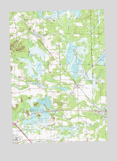
Wyeville, WI USGS Topographic Map
Click on map above to begin viewing in our Map Viewer.

This topographic map contains these locations and features:
Feature Name Type Latitude Longitude GNIS ID View Map
136 ReservoirReservoirN44.0300°W90.3785°1792711View Map
Benjaminville School (historical)SchoolN44.0033°W90.4718°1846181View Map
Brandy CreekStreamN44.0505°W90.3926°1562150View Map
Dandy Creek 11 2WP197 DamDamN44.0300°W90.3785°1792710View Map
Dannavang CemeteryCemeteryN44.1008°W90.4598°1563706View Map
Dannavang ChurchChurchN44.1027°W90.4543°1563707View Map
Dead CreekStreamN44.0539°W90.3926°1563765View Map
Jay CreekStreamN44.1075°W90.4229°1567106View Map
Johnson C 12033 DamDamN44.1016°W90.4551°1792857View Map
Kreyer CreekStreamN44.0044°W90.4329°1567646View Map
Lake 18 13 22ReservoirN44.1239°W90.4144°1792197View Map
Lake 26 2 and Lake 23 12d 13ReservoirN44.1016°W90.4551°1792858View Map
Lake 32 11 57ReservoirN44.0716°W90.4068°1792924View Map
Lake 5 7 58ReservoirN44.0710°W90.4150°1792922View Map
Lowry CreekStreamN44.1036°W90.4343°1568769View Map
Mill CreekStreamN44.0519°W90.4437°1569474View Map
Mud CreekStreamN44.0133°W90.4326°1569890View Map
North Tomah Cranberry Company 3WR483 DamDamN44.0216°W90.4885°1792787View Map
Prehn Cranberry Company AirportAirportN44.0117°W90.3893°2444103View Map
Salzwedel Cranberry MarshLocaleN44.0869°W90.4756°2723770View Map
Sand CreekStreamN44.0955°W90.4215°1573663View Map
Tomah Veterans Affairs Medical CenterHospitalN44.0031°W90.4934°2698463View Map
Town of La GrangeCivilN44.0336°W90.4929°1583506View Map
Town of LincolnCivilN44.1164°W90.4936°1583567View Map
Valley Corporation DamDamN44.0666°W90.4101°1792921View Map
Valley Corporation DamDamN44.0716°W90.4068°1792923View Map
Valley JunctionPopulated PlaceN44.0533°W90.4124°1576019View Map
Valley View School (historical)SchoolN44.0297°W90.4235°1846315View Map
Veterans Affairs Fire DepartmentBuildingN44.0032°W90.4987°2697715View Map
Village of WyevilleCivilN44.0278°W90.3860°1584487View Map
Water Mill DamDamN44.0558°W90.4626°1792903View Map
Water Mill PondReservoirN44.0563°W90.4673°1576284View Map
Water Mill School (historical)SchoolN44.0519°W90.4757°1846320View Map
Wetherby DamDamN44.1216°W90.4135°1792196View Map
Whisky CreekStreamN44.1194°W90.4568°1576615View Map
Wood CemeteryCemeteryN44.0341°W90.4287°1576960View Map
WyevillePopulated PlaceN44.0283°W90.3846°1577062View Map
Wyeville Elementary SchoolSchoolN44.0278°W90.3903°1846327View Map

Note: Coordinates in the location and feature list above are referenced to NAD83 datum.


Copyright (C) 2008-2024 Ryan Niemi / Sunset Dynamics ... All Rights Reserved