TopoQuest Logo
Do you find TopoQuest useful?
Help keep TopoQuest running and adding new maps/features by donating!
Bitcoin:  19c7KJd3qBynnjoSw5npx9KScwjBe4ifkT
Litecoin:  LXs6TkuXGGXo1vDsWCkWVdjQX94eUKd6ui
Home View Maps Find Maps Find Places Resources & Links


Iconium, Missouri Topographic Map

USGS Map Title: Iconium, MO
USGS Map MRC: 38093A5
DRG (GeoTIFF) Download: o38093a5.tif


Neighboring USGS Topographic Map Quads:


  Lowry City, MO  
38093B6
 

  Ninnescah Park, MO  
38093B5
 

  Warsaw West, MO  
38093B4
 

  Osceola, MO  
38093A6
 

  Iconium, MO  
38093A5
 

  Quincy, MO  
38093A4
 

  Vista, MO  
37093H6
 

  Weaubleau, MO  
37093H5
 

  Wheatland, MO  
37093H4


Map MRC Location:

N39°
W94°
N39°
W93°
H8 H7 H6 H5 H4 H3 H2 H1
G8 G7 G6 G5 G4 G3 G2 G1
F8 F7 F6 F5 F4 F3 F2 F1
E8 E7 E6 E5 E4 E3 E2 E1
D8 D7 D6 D5 D4 D3 D2 D1
C8 C7 C6 C5 C4 C3 C2 C1
B8 B7 B6 B5 B4 B3 B2 B1
A8 A7 A6 A5 A4 A3 A2 A1
N38°
W94°
N38°
W93°

Iconium, MO USGS 1:24K Topographic Map Preview:
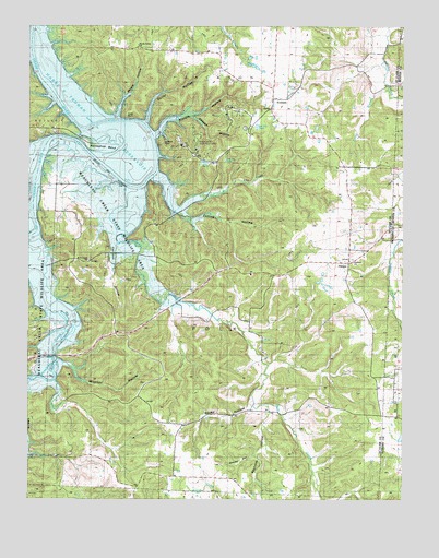
Iconium, MO USGS Topographic Map
Click on map above to begin viewing in our Map Viewer.

This topographic map contains these locations and features:
Feature Name Type Latitude Longitude GNIS ID View Map
Bear CreekStreamN38.0825°W93.5874°755736View Map
Bear Creek CemeteryCemeteryN38.0634°W93.6055°758193View Map
Bear Creek ChurchChurchN38.0634°W93.6052°758426View Map
Bear Creek School (historical)SchoolN38.0652°W93.5955°757199View Map
Big Sink Hole (historical)BasinN38.0386°W93.5902°755772View Map
Blalock HollowValleyN38.0970°W93.5841°755785View Map
Briley CreekStreamN38.0853°W93.5844°755819View Map
Carey BranchStreamN38.1086°W93.5058°755858View Map
Catherine (historical)LocaleN38.0034°W93.5883°758125View Map
Catherine Post OfficePost OfficeN38.0034°W93.5883°759579View Map
Cedar PointCliffN38.1017°W93.5938°755869View Map
Collins HollowValleyN38.0759°W93.5777°755912View Map
Concord School (historical)SchoolN38.0289°W93.5333°755916View Map
Corbin (historical)Populated PlaceN38.0659°W93.5966°755931View Map
Debeker HollowValleyN38.1014°W93.5716°755980View Map
Garrison HollowValleyN38.0645°W93.5963°756090View Map
Goshen ChurchChurchN38.0628°W93.5171°758196View Map
H. Roe Bartle Scout ReservationLocaleN38.0939°W93.5735°757028View Map
HarperPopulated PlaceN38.0625°W93.5185°756155View Map
Harper SchoolSchoolN38.0630°W93.5179°757147View Map
Horseshoe BendBendN38.0917°W93.5944°756191View Map
IconiumPopulated PlaceN38.1059°W93.5447°756204View Map
Iconium CemeteryCemeteryN38.1034°W93.5438°758195View Map
Iconium ChurchChurchN38.1034°W93.5447°758194View Map
Iconium Fire Protection District Station 1BuildingN38.1091°W93.5443°2621480View Map
Iconium School (historical)SchoolN38.1089°W93.5438°757200View Map
Liberty Church (historical)ChurchN38.1142°W93.5169°1669619View Map
Liberty School (historical)SchoolN38.1142°W93.5169°766163View Map
Moore HollowValleyN38.1009°W93.5972°756410View Map
Prairie Grove School (historical)SchoolN38.0225°W93.5013°748440View Map
Reynolds HollowValleyN38.0242°W93.5458°756577View Map
Rooke HollowValleyN38.0245°W93.5510°756609View Map
Roth Lake DamDamN38.0250°W93.5319°765463View Map
Shady Grove ChurchChurchN38.1200°W93.5891°758192View Map
Snyder HollowValleyN38.0114°W93.5499°756737View Map
Square PrairieAreaN38.0214°W93.5824°757201View Map
Square Prairie School (historical)SchoolN38.0206°W93.5841°756759View Map
Suitor HollowValleyN38.0998°W93.5880°756768View Map
Township of PolkCivilN38.0455°W93.5616°767319View Map
Weaubleau Creek State Wildlife AreaParkN38.0734°W93.6041°758200View Map
Wisener HollowValleyN38.0361°W93.6141°756915View Map
Wolf CreekStreamN38.1159°W93.6241°756919View Map

Note: Coordinates in the location and feature list above are referenced to NAD83 datum.


Copyright (C) 2008-2025 Ryan Niemi / Sunset Dynamics ... All Rights Reserved