TopoQuest Logo
Do you find TopoQuest useful?
Help keep TopoQuest running and adding new maps/features by donating!
Bitcoin:  19c7KJd3qBynnjoSw5npx9KScwjBe4ifkT
Litecoin:  LXs6TkuXGGXo1vDsWCkWVdjQX94eUKd6ui
Home View Maps Find Maps Find Places Resources & Links


Barnett Shoals, Georgia Topographic Map

USGS Map Title: Barnett Shoals, GA
USGS Map MRC: 33083G3
DRG (GeoTIFF) Download: o33083g3.tif


Neighboring USGS Topographic Map Quads:


  Athens West, GA  
33083H4
 

  Athens East, GA  
33083H3
 

  Crawford, GA  
33083H2
 

  Watkinsville, GA  
33083G4
 

  Barnett Shoals, GA  
33083G3
 

  Maxeys, GA  
33083G2
 

  Apalachee, GA  
33083F4
 

  Greshamville, GA  
33083F3
 

  Penfield, GA  
33083F2


Map MRC Location:

N34°
W84°
N34°
W83°
H8 H7 H6 H5 H4 H3 H2 H1
G8 G7 G6 G5 G4 G3 G2 G1
F8 F7 F6 F5 F4 F3 F2 F1
E8 E7 E6 E5 E4 E3 E2 E1
D8 D7 D6 D5 D4 D3 D2 D1
C8 C7 C6 C5 C4 C3 C2 C1
B8 B7 B6 B5 B4 B3 B2 B1
A8 A7 A6 A5 A4 A3 A2 A1
N33°
W84°
N33°
W83°

Barnett Shoals, GA USGS 1:24K Topographic Map Preview:
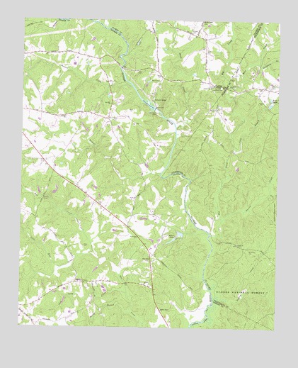
Barnett Shoals, GA USGS Topographic Map
Click on map above to begin viewing in our Map Viewer.

This topographic map contains these locations and features:
Feature Name Type Latitude Longitude GNIS ID View Map
Antioch CemeteryCemeteryN33.7676°W83.3146°356682View Map
Antioch ChurchChurchN33.7676°W83.3140°354360View Map
Astondale School (historical)SchoolN33.8143°W83.3610°356685View Map
Barnett BluffsPopulated PlaceN33.8593°W83.3213°1672654View Map
Barnett ShoalsLocaleN33.8426°W83.3115°354465View Map
Barnett Shoals DamDamN33.8387°W83.3104°327013View Map
Barnetts BridgeBridgeN33.8560°W83.3265°1672656View Map
Barnetts ShoalsBarN33.8393°W83.3107°356688View Map
Barrow CreekStreamN33.7935°W83.2768°327015View Map
BelmontPopulated PlaceN33.8396°W83.2877°356689View Map
Belmont School (historical)SchoolN33.8743°W83.3088°1672662View Map
Big CreekStreamN33.7882°W83.2821°327107View Map
Big Creek Church (historical)ChurchN33.8482°W83.2779°356694View Map
Big Creek Hardshell CemeteryCemeteryN33.8476°W83.2779°327110View Map
Cedar CreekStreamN33.8732°W83.3360°327395View Map
Coon MountainSummitN33.8401°W83.3152°356710View Map
Corinth CemeteryCemeteryN33.8482°W83.2840°356711View Map
Corinth ChurchChurchN33.8482°W83.2838°355316View Map
Ebenezer Church (historical)ChurchN33.8612°W83.3579°356723View Map
Edwards CemeteryCemeteryN33.8609°W83.3582°356725View Map
ElderPopulated PlaceN33.7682°W83.3471°355660View Map
Elder CemeteryCemeteryN33.7832°W83.3438°327747View Map
Elder CemeteryCemeteryN33.8001°W83.3357°327748View Map
Elder Covered BridgeBridgeN33.8026°W83.3638°356726View Map
Elder DivisionCivilN33.7729°W83.3405°1936245View Map
Elders LakesReservoirN33.7868°W83.2988°327749View Map
Elders Mill (historical)LocaleN33.7943°W83.3677°356729View Map
Ellis CreekStreamN33.8048°W83.2538°327756View Map
Falling Camp TrailTrailN33.7623°W83.2599°330618View Map
Falling CreekStreamN33.7621°W83.2804°327793View Map
Fambrough Bridge (historical)BridgeN33.7696°W83.2849°356732View Map
Fambrough CemeteryCemeteryN33.7609°W83.3002°356733View Map
Flat Rock School (historical)SchoolN33.8354°W83.3315°356737View Map
Goshen School (historical)SchoolN33.7682°W83.3471°356739View Map
Goulding CreekStreamN33.8576°W83.2604°327982View Map
Green Hills Country ClubLocaleN33.8504°W83.3082°356740View Map
Hardigree CemeteryCemeteryN33.7679°W83.3438°328059View Map
Harris CemeteryCemeteryN33.8512°W83.2715°328077View Map
Hickory PointPopulated PlaceN33.8685°W83.3138°1672770View Map
Horseshoe BendBendN33.8112°W83.3063°356751View Map
IdylwoodPopulated PlaceN33.8746°W83.3143°1672785View Map
Johnson CemeteryCemeteryN33.8357°W83.3535°356756View Map
Johnson ChurchChurchN33.8360°W83.3538°328345View Map
Little Rose CreekStreamN33.7807°W83.3388°328574View Map
Long BranchStreamN33.8229°W83.2704°328622View Map
Lower Elders DamDamN33.7893°W83.2971°338580View Map
Lower Elders LakeReservoirN33.7885°W83.2969°338581View Map
McRee Mill (historical)LocaleN33.8482°W83.3215°356767View Map
Morton ChapelChurchN33.8746°W83.2874°328846View Map
Mortons Chapel School (historical)SchoolN33.8743°W83.2874°1672816View Map
Moss CreekStreamN33.8476°W83.2729°328856View Map
Mounds TrailTrailN33.7562°W83.2765°330981View Map
Nicholson CemeteryCemeteryN33.7821°W83.2632°329031View Map
Oak Hill ChurchChurchN33.8410°W83.3318°329074View Map
Oak PointPopulated PlaceN33.8437°W83.3310°356772View Map
Oconee ChurchChurchN33.7840°W83.2690°329085View Map
Oconee County Fire Department Station 5BuildingN33.7866°W83.3165°2603582View Map
Old Heritage FarmPopulated PlaceN33.8626°W83.3118°1672830View Map
Old Mill ChasePopulated PlaceN33.8496°W83.3313°356782View Map
Pine HillsPopulated PlaceN33.8390°W83.3418°356787View Map
Pioneer WoodsPopulated PlaceN33.8426°W83.3282°356789View Map
Porters CreekStreamN33.8482°W83.3215°329306View Map
Puryear CemeteryCemeteryN33.8707°W83.2932°329339View Map
River FarmsPopulated PlaceN33.8585°W83.3377°356796View Map
Rocky BranchStreamN33.7562°W83.3204°329486View Map
Rose HillPopulated PlaceN33.7790°W83.3113°332917View Map
Rose Hill School (historical)SchoolN33.7785°W83.3110°356798View Map
Rutherford (historical)Populated PlaceN33.8501°W83.3032°326140View Map
Scull Shoals Archeological AreaParkN33.7554°W83.2804°330619View Map
Scull Shoals Experimental ForestParkN33.7585°W83.2721°330697View Map
Shoal CreekStreamN33.8318°W83.2996°329683View Map
Slab Camp CreekStreamN33.7640°W83.3221°329723View Map
Smith CemeteryCemeteryN33.8421°W83.2577°329733View Map
Temple ChurchChurchN33.8393°W83.2799°329953View Map
Thomas Store (historical)LocaleN33.8071°W83.3485°356817View Map
Trible CemeteryCemeteryN33.8482°W83.2577°330050View Map
Tuck CemeteryCemeteryN33.8629°W83.2854°330056View Map
Twin LakesReservoirN33.8423°W83.2535°330090View Map
Upper Elders DamDamN33.7696°W83.2990°338578View Map
Upper Elders LakeReservoirN33.7696°W83.2990°338579View Map
Veal CemeteryCemeteryN33.8537°W83.3190°330129View Map
Walnut Grove ChurchChurchN33.7573°W83.3060°330151View Map
Ward CemeteryCemeteryN33.8348°W83.3307°330158View Map
Ward CemeteryCemeteryN33.8384°W83.3210°330159View Map
Wildcat CreekStreamN33.8132°W83.3068°330273View Map
Willoughby CemeteryCemeteryN33.7868°W83.3174°330302View Map
Wire Bridge (historical)BridgeN33.7882°W83.2827°356830View Map
Young CemeteryCemeteryN33.8523°W83.3077°330414View Map

Note: Coordinates in the location and feature list above are referenced to NAD83 datum.


Copyright (C) 2008-2025 Ryan Niemi / Sunset Dynamics ... All Rights Reserved