TopoQuest Logo
Do you find TopoQuest useful?
Help keep TopoQuest running and adding new maps/features by donating!
Bitcoin:  19c7KJd3qBynnjoSw5npx9KScwjBe4ifkT
Litecoin:  LXs6TkuXGGXo1vDsWCkWVdjQX94eUKd6ui
Home View Maps Find Maps Find Places Resources & Links


Greshamville, Georgia Topographic Map

USGS Map Title: Greshamville, GA
USGS Map MRC: 33083F3
DRG (GeoTIFF) Download: o33083f3.tif


Neighboring USGS Topographic Map Quads:


  Watkinsville, GA  
33083G4
 

  Barnett Shoals, GA  
33083G3
 

  Maxeys, GA  
33083G2
 

  Apalachee, GA  
33083F4
 

  Greshamville, GA  
33083F3
 

  Penfield, GA  
33083F2
 

  Madison, GA  
33083E4
 

  Buckhead, GA  
33083E3
 

  Greensboro, GA  
33083E2


Map MRC Location:

N34°
W84°
N34°
W83°
H8 H7 H6 H5 H4 H3 H2 H1
G8 G7 G6 G5 G4 G3 G2 G1
F8 F7 F6 F5 F4 F3 F2 F1
E8 E7 E6 E5 E4 E3 E2 E1
D8 D7 D6 D5 D4 D3 D2 D1
C8 C7 C6 C5 C4 C3 C2 C1
B8 B7 B6 B5 B4 B3 B2 B1
A8 A7 A6 A5 A4 A3 A2 A1
N33°
W84°
N33°
W83°

Greshamville, GA USGS 1:24K Topographic Map Preview:
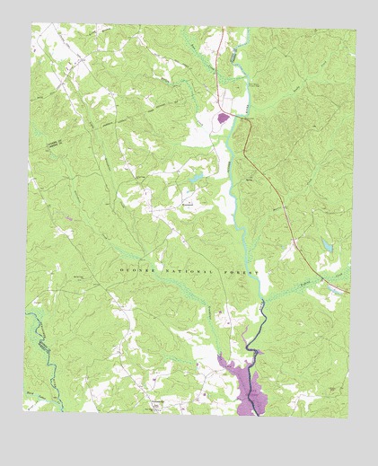
Greshamville, GA USGS Topographic Map
Click on map above to begin viewing in our Map Viewer.

This topographic map contains these locations and features:
Feature Name Type Latitude Longitude GNIS ID View Map
Ashley LakeReservoirN33.6802°W83.2589°330639View Map
Ashley Lake DamDamN33.6796°W83.2574°339044View Map
Bear LakeReservoirN33.7012°W83.3100°348647View Map
Bonds Academy (historical)SchoolN33.7071°W83.3124°348651View Map
Briar CreekStreamN33.6287°W83.3679°327216View Map
Brown-Jones CemeteryCemeteryN33.6968°W83.3702°1705393View Map
Center School (historical)SchoolN33.7429°W83.3618°356708View Map
Cloverfield Hunt CampLocaleN33.6579°W83.3154°330691View Map
Cochran CemeteryCemeteryN33.6923°W83.3432°1705397View Map
Dyar Pasture Hunt CampLocaleN33.6462°W83.2907°330637View Map
Ellison CreekStreamN33.7148°W83.2979°327758View Map
Fishing CreekStreamN33.6615°W83.2824°327825View Map
Fishing Creek Hunt CampLocaleN33.6810°W83.2738°330640View Map
Fork ChapelChurchN33.6268°W83.3238°355870View Map
Foster CemeteryCemeteryN33.6468°W83.3390°1705403View Map
Greenbrier CreekStreamN33.6740°W83.3271°356100View Map
GreshamvillePopulated PlaceN33.6265°W83.3238°328010View Map
Greshamville CemeteryCemeteryN33.6260°W83.3240°1705408View Map
Greshamville DivisionCivilN33.6448°W83.3120°1936299View Map
Greshamville Fire DepartmentBuildingN33.6264°W83.3242°2604708View Map
Hard Labor CreekStreamN33.6262°W83.3599°356167View Map
Harris CreekStreamN33.6746°W83.2896°328079View Map
Harris Creek Hunt CampLocaleN33.6815°W83.2885°330638View Map
Hays CemeteryCemeteryN33.6381°W83.2976°1705409View Map
Little Creek ChurchChurchN33.7007°W83.3332°328539View Map
Little Greenbrier CreekStreamN33.6318°W83.2885°328551View Map
Macedonia Hunt CampLocaleN33.7157°W83.2649°330642View Map
Magnolia Hunt CampLocaleN33.6521°W83.2607°330636View Map
McWhorter CemeteryCemeteryN33.6299°W83.3084°348690View Map
Mother Word ChurchChurchN33.7093°W83.3396°348694View Map
Mount Olive Church (historical)ChurchN33.6782°W83.3110°348696View Map
New Hope ChurchChurchN33.6260°W83.3240°329003View Map
Oakland CemeteryCemeteryN33.6454°W83.2504°1705424View Map
Oakland Lookout TowerTowerN33.6346°W83.2549°330634View Map
Oconee Lake Hunt CampLocaleN33.6471°W83.2840°330635View Map
Oconee River Campground and Picnic AreaLocaleN33.7212°W83.2899°330972View Map
Perkins CemeteryCemeteryN33.6343°W83.3465°1705429View Map
Rose CreekStreamN33.7343°W83.2907°329521View Map
Sandy CreekStreamN33.7248°W83.2893°329589View Map
Scull Shoals (historical)Populated PlaceN33.7285°W83.2927°348717View Map
Scull Shoals Historic AreaLocaleN33.7318°W83.2907°329625View Map
Scull Shoals TrailTrailN33.7271°W83.2902°350744View Map
Smith AirportAirportN33.6766°W83.2611°2625402View Map
Spring Creek ChurchChurchN33.6682°W83.3524°329796View Map
Thompson Grove School (historical)SchoolN33.7026°W83.3740°348726View Map
Toombs LakeReservoirN33.7042°W83.3111°339043View Map
Toombs Lake DamDamN33.7039°W83.3108°339042View Map
Trembling Bridge Hunt CampLocaleN33.6582°W83.3738°330690View Map
Trembling Bridge Shooting RangeLocaleN33.6601°W83.3718°330633View Map
W S Ashley DamDamN33.7151°W83.2565°336436View Map
Watson SpringSpringN33.7012°W83.2913°330641View Map
Wheeler CemeteryCemeteryN33.6923°W83.2618°1705443View Map
WrayswoodPopulated PlaceN33.6935°W83.3146°333471View Map

Note: Coordinates in the location and feature list above are referenced to NAD83 datum.


Copyright (C) 2008-2025 Ryan Niemi / Sunset Dynamics ... All Rights Reserved