TopoQuest Logo
Do you find TopoQuest useful?
Help keep TopoQuest running and adding new maps/features by donating!
Bitcoin:  19c7KJd3qBynnjoSw5npx9KScwjBe4ifkT
Litecoin:  LXs6TkuXGGXo1vDsWCkWVdjQX94eUKd6ui
Home View Maps Find Maps Find Places Resources & Links


Waukeenah, Florida Topographic Map

USGS Map Title: Waukeenah, FL
USGS Map MRC: 30083D8
DRG (GeoTIFF) Download: o30083d8.tif


Neighboring USGS Topographic Map Quads:


  Miccosukee, FL  
30084E1
 

  Lake Miccosukee, FL  
30083E8
 

  Monticello, FL  
30083E7
 

  Lloyd, FL  
30084D1
 

  Waukeenah, FL  
30083D8
 

  Lamont, FL  
30083D7
 

  Cody, FL  
30084C1
 

  Wacissa, FL  
30083C8
 

  Lamont SE, FL  
30083C7


Map MRC Location:

N31°
W84°
N31°
W83°
H8 H7 H6 H5 H4 H3 H2 H1
G8 G7 G6 G5 G4 G3 G2 G1
F8 F7 F6 F5 F4 F3 F2 F1
E8 E7 E6 E5 E4 E3 E2 E1
D8 D7 D6 D5 D4 D3 D2 D1
C8 C7 C6 C5 C4 C3 C2 C1
B8 B7 B6 B5 B4 B3 B2 B1
A8 A7 A6 A5 A4 A3 A2 A1
N30°
W84°
N30°
W83°

Waukeenah, FL USGS 1:24K Topographic Map Preview:
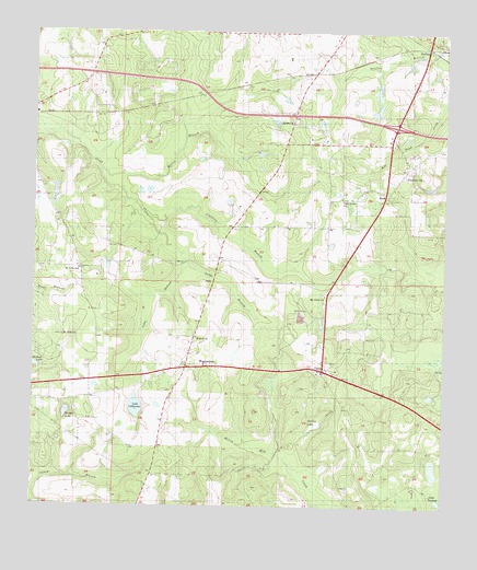
Waukeenah, FL USGS Topographic Map
Click on map above to begin viewing in our Map Viewer.

This topographic map contains these locations and features:
Feature Name Type Latitude Longitude GNIS ID View Map
Bethel ChurchChurchN30.4188°W83.9502°278545View Map
CappsPopulated PlaceN30.4105°W83.9110°280013View Map
Coocksey BranchStreamN30.4508°W83.9660°280729View Map
Cuba BranchStreamN30.4377°W83.9532°281142View Map
DriftonPopulated PlaceN30.4955°W83.8793°281765View Map
Ebenezer ChurchChurchN30.4608°W83.8866°282063View Map
Galilee LakeLakeN30.3968°W83.9135°282886View Map
Hatchcakamocha (historical)Populated PlaceN30.4669°W83.8999°294538View Map
Jefferson CountyCivilN30.4235°W83.9005°295733View Map
Jefferson County Middle - High SchoolSchoolN30.4909°W83.8788°298464View Map
Lake CatherineLakeN30.4012°W83.9683°280155View Map
Lake JacksonLakeN30.3764°W83.8752°284695View Map
Lang BranchStreamN30.4385°W83.9535°285337View Map
Morris BranchStreamN30.4633°W83.9799°287146View Map
Mount Olive CemeteryCemeteryN30.4260°W83.9193°287249View Map
Mount Olive ChurchChurchN30.4296°W83.9102°287268View Map
Mount Zion ChurchChurchN30.4188°W83.9904°287356View Map
NashPopulated PlaceN30.4544°W83.8929°294863View Map
Pine Grove ChurchChurchN30.4546°W83.9054°288846View Map
Saint Rilla SchoolSchoolN30.4360°W83.9857°290386View Map
Sardis ChurchChurchN30.4744°W83.9202°290692View Map
Shadow LakeReservoirN30.4121°W83.9999°290892View Map
WaukeenahPopulated PlaceN30.4113°W83.9529°294191View Map
Waukeenah Census Designated PlaceCensusN30.4020°W83.9600°2628538View Map
Waukeenah United Methodist ChurchChurchN30.4132°W83.9516°2450834View Map
Wooten LakeLakeN30.3996°W83.9897°293529View Map

Note: Coordinates in the location and feature list above are referenced to NAD83 datum.


Copyright (C) 2008-2025 Ryan Niemi / Sunset Dynamics ... All Rights Reserved