TopoQuest Logo
Do you find TopoQuest useful?
Help keep TopoQuest running and adding new maps/features by donating!
Bitcoin:  19c7KJd3qBynnjoSw5npx9KScwjBe4ifkT
Litecoin:  LXs6TkuXGGXo1vDsWCkWVdjQX94eUKd6ui
Home View Maps Find Maps Find Places Resources & Links


Lake Miccosukee, Florida Topographic Map

USGS Map Title: Lake Miccosukee, FL
USGS Map MRC: 30083E8
DRG (GeoTIFF) Download: o30083e8.tif


Neighboring USGS Topographic Map Quads:


  Miccosukee NE, GA  
30084F1
 

  Metcalf, GA  
30083F8
 

  Monticello NE, FL  
30083F7
 

  Miccosukee, FL  
30084E1
 

  Lake Miccosukee, FL  
30083E8
 

  Monticello, FL  
30083E7
 

  Lloyd, FL  
30084D1
 

  Waukeenah, FL  
30083D8
 

  Lamont, FL  
30083D7


Map MRC Location:

N31°
W84°
N31°
W83°
H8 H7 H6 H5 H4 H3 H2 H1
G8 G7 G6 G5 G4 G3 G2 G1
F8 F7 F6 F5 F4 F3 F2 F1
E8 E7 E6 E5 E4 E3 E2 E1
D8 D7 D6 D5 D4 D3 D2 D1
C8 C7 C6 C5 C4 C3 C2 C1
B8 B7 B6 B5 B4 B3 B2 B1
A8 A7 A6 A5 A4 A3 A2 A1
N30°
W84°
N30°
W83°

Lake Miccosukee, FL USGS 1:24K Topographic Map Preview:
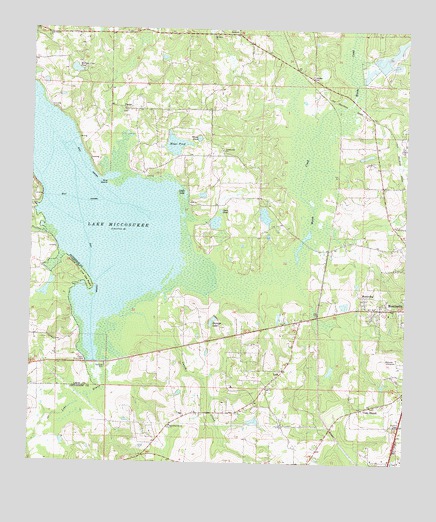
Lake Miccosukee, FL USGS Topographic Map
Click on map above to begin viewing in our Map Viewer.

This topographic map contains these locations and features:
Feature Name Type Latitude Longitude GNIS ID View Map
AlmaPopulated PlaceN30.6110°W83.9063°294650View Map
Aucilla Christian AcademySchoolN30.5435°W83.8780°301538View Map
Caney CreekStreamN30.5430°W83.9660°279978View Map
Casa BlancoPopulated PlaceN30.5163°W83.8877°294707View Map
Casa Blanco ChurchChurchN30.5152°W83.8899°300045View Map
FestusPopulated PlaceN30.6016°W83.9688°294765View Map
Gulf Atlantic Trailer ParkPopulated PlaceN30.5279°W83.9161°2450818View Map
Harvest CenterChurchN30.5211°W83.8767°2450830View Map
JarrettPopulated PlaceN30.6238°W83.9341°295378View Map
Jefferson County Sheriff's OfficeBuildingN30.5024°W83.8819°2333112View Map
Juniors Hill ChurchChurchN30.5902°W83.9366°284984View Map
Lake MiccosukeeReservoirN30.5291°W83.9782°286773View Map
Little LakeLakeN30.5775°W83.9488°285722View Map
Live Oak PointCapeN30.5508°W83.9807°285880View Map
LoisPopulated PlaceN30.5263°W83.9157°295415View Map
Macedonia ChurchChurchN30.5008°W83.8785°286250View Map
Mays PondSwampN30.5918°W83.9521°286558View Map
Monticello Fire Control Headquarters Fire TowerTowerN30.5113°W83.8768°300043View Map
MontivillaPopulated PlaceN30.5477°W83.8885°295463View Map
Mount Olive ChurchChurchN30.6235°W83.9396°287275View Map
Norrias Club PondLakeN30.6133°W83.9858°298246View Map
Open PondLakeN30.5727°W83.9368°288172View Map
Panther CreekStreamN30.5658°W83.9952°288461View Map
Perkins Plantation PondLakeN30.5715°W83.9222°298245View Map
Pine IslandIslandN30.5802°W83.9741°288867View Map
Raineys LakeReservoirN30.5410°W83.9390°289447View Map
Sweetfield ChurchChurchN30.5110°W83.9527°291935View Map
Union Branch ChurchChurchN30.6238°W83.9952°292649View Map
White PondLakeN30.5936°W83.9444°293224View Map
Wilson Shepherd PondLakeN30.5405°W83.9016°298248View Map

Note: Coordinates in the location and feature list above are referenced to NAD83 datum.


Copyright (C) 2008-2025 Ryan Niemi / Sunset Dynamics ... All Rights Reserved