TopoQuest Logo
Do you find TopoQuest useful?
Help keep TopoQuest running and adding new maps/features by donating!
Bitcoin:  19c7KJd3qBynnjoSw5npx9KScwjBe4ifkT
Litecoin:  LXs6TkuXGGXo1vDsWCkWVdjQX94eUKd6ui
Home View Maps Find Maps Find Places Resources & Links


Wayland, Missouri Topographic Map

USGS Map Title: Wayland, MO
USGS Map MRC: 40091D5
DRG (GeoTIFF) Download: o40091d5.tif


Neighboring USGS Topographic Map Quads:


  Croton, IA  
40091E6
 

  Argyle, IA  
40091E5
 

  Nauvoo, IL  
40091E4
 

  Kahoka, MO  
40091D6
 

  Wayland, MO  
40091D5
 

  Keokuk, IA  
40091D4
 

  Saint Patrick, MO  
40091C6
 

  Kahoka SE, MO  
40091C5
 

  Warsaw, IL  
40091C4


Map MRC Location:

N41°
W92°
N41°
W91°
H8 H7 H6 H5 H4 H3 H2 H1
G8 G7 G6 G5 G4 G3 G2 G1
F8 F7 F6 F5 F4 F3 F2 F1
E8 E7 E6 E5 E4 E3 E2 E1
D8 D7 D6 D5 D4 D3 D2 D1
C8 C7 C6 C5 C4 C3 C2 C1
B8 B7 B6 B5 B4 B3 B2 B1
A8 A7 A6 A5 A4 A3 A2 A1
N40°
W92°
N40°
W91°

Wayland, MO USGS 1:24K Topographic Map Preview:
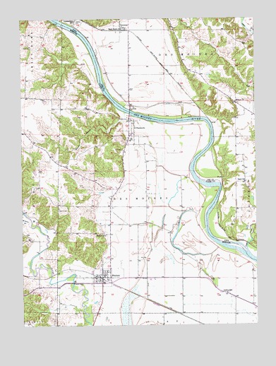
Wayland, MO USGS Topographic Map
Click on map above to begin viewing in our Map Viewer.

This topographic map contains these locations and features:
Feature Name Type Latitude Longitude GNIS ID View Map
Amborn-Pagin Wildlife AreaParkN40.4667°W91.5238°1981383View Map
Bartlett SchoolSchoolN40.4117°W91.5813°713706View Map
City of WaylandCivilN40.3963°W91.5754°2397232View Map
Dinsmore SchoolSchoolN40.4503°W91.5668°731735View Map
Eagle SchoolSchoolN40.4334°W91.5063°456101View Map
Glades Lake DamDamN40.4217°W91.5902°761841View Map
Independent SchoolSchoolN40.4992°W91.5963°457785View Map
Jenkins SchoolSchoolN40.3878°W91.5160°720297View Map
Lawrence School (historical)SchoolN40.4542°W91.6232°731734View Map
Melrose ChurchChurchN40.4659°W91.5110°458959View Map
Moores MillLocaleN40.4173°W91.6221°731736View Map
Oak Hill CemeteryCemeteryN40.4220°W91.6060°723618View Map
Oakland CemeteryCemeteryN40.4981°W91.5960°459751View Map
Saint FrancisvillePopulated PlaceN40.4584°W91.5690°725749View Map
Saint Francisville BridgeBridgeN40.4620°W91.5668°1981382View Map
Saint Francisville Census Designated PlaceCensusN40.4501°W91.5714°2587112View Map
Sand CemeteryCemeteryN40.4714°W91.5671°461388View Map
Sand CemeteryCemeteryN40.4517°W91.5627°726004View Map
Sand Prairie StationLocaleN40.4956°W91.5710°461404View Map
Sugar CreekStreamN40.4045°W91.5054°462061View Map
Sugar Creek (historical)Populated PlaceN40.4078°W91.5052°464347View Map
Township of Des MoinesCivilN40.4218°W91.5622°766492View Map
VincennesPopulated PlaceN40.4964°W91.5699°462576View Map
Vincennes (historical)LocaleN40.4964°W91.5699°1981381View Map
Vincennes Post Office (historical)Post OfficeN40.4964°W91.5699°1981384View Map
WaylandPopulated PlaceN40.3945°W91.5832°735902View Map
Wayland BridgeBridgeN40.3925°W91.5982°731737View Map
Wayland Post OfficePost OfficeN40.3946°W91.5819°2783135View Map
Wayland Volunteer Fire Protection AssociationBuildingN40.3950°W91.5822°2621694View Map
Weaver BranchStreamN40.4617°W91.5704°735903View Map
Weaver BranchStreamN40.4156°W91.6207°728444View Map
Winter-Wood LakeReservoirN40.4380°W91.6183°762021View Map
Winter-Wood Lake DamDamN40.4384°W91.6185°762020View Map
Wolf CemeteryCemeteryN40.4467°W91.5727°729036View Map

Note: Coordinates in the location and feature list above are referenced to NAD83 datum.


Copyright (C) 2008-2024 Ryan Niemi / Sunset Dynamics ... All Rights Reserved