TopoQuest Logo
Do you find TopoQuest useful?
Help keep TopoQuest running and adding new maps/features by donating!
Bitcoin:  19c7KJd3qBynnjoSw5npx9KScwjBe4ifkT
Litecoin:  LXs6TkuXGGXo1vDsWCkWVdjQX94eUKd6ui
Home View Maps Find Maps Find Places Resources & Links


Weathers, Arkansas Topographic Map

USGS Map Title: Weathers, AR
USGS Map MRC: 35093H5
DRG (GeoTIFF) Download: o35093h5.tif


Neighboring USGS Topographic Map Quads:


  Huntsville, AR  
36093A6
 

  Kingston, AR  
36093A5
 

  Osage SW, AR  
36093A4
 

  Witter, AR  
35093H6
 

  Weathers, AR  
35093H5
 

  Boxley, AR  
35093H4
 

  Pettigrew, AR  
35093G6
 

  Boston, AR  
35093G5
 

  Fallsville, AR  
35093G4


Map MRC Location:

N36°
W94°
N36°
W93°
H8 H7 H6 H5 H4 H3 H2 H1
G8 G7 G6 G5 G4 G3 G2 G1
F8 F7 F6 F5 F4 F3 F2 F1
E8 E7 E6 E5 E4 E3 E2 E1
D8 D7 D6 D5 D4 D3 D2 D1
C8 C7 C6 C5 C4 C3 C2 C1
B8 B7 B6 B5 B4 B3 B2 B1
A8 A7 A6 A5 A4 A3 A2 A1
N35°
W94°
N35°
W93°

Weathers, AR USGS 1:24K Topographic Map Preview:
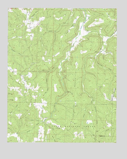
Weathers, AR USGS Topographic Map
Click on map above to begin viewing in our Map Viewer.

This topographic map contains these locations and features:
Feature Name Type Latitude Longitude GNIS ID View Map
Allen KnobSummitN35.9142°W93.6213°70430View Map
Bethel CemeteryCemeteryN35.8823°W93.5249°70638View Map
Carpenter CemeteryCemeteryN35.8926°W93.5488°71016View Map
Cowcumber HollowValleyN35.9551°W93.5246°71268View Map
Dripping Springs CemeteryCemeteryN35.8884°W93.5641°71422View Map
Eagle Gap CemeteryCemeteryN35.9090°W93.5485°71485View Map
Felkins CreekStreamN35.9773°W93.5424°71603View Map
Flat Rock HollowValleyN35.9398°W93.5791°71627View Map
Marksburg HollowValleyN35.9129°W93.5266°72554View Map
Mink CreekStreamN35.8909°W93.5805°72693View Map
Mitchell BranchStreamN35.8942°W93.5821°72699View Map
Mount Olive CemeteryCemeteryN35.9942°W93.5102°72760View Map
Penitentiary MountainSummitN35.9265°W93.5455°73040View Map
Pine CreekStreamN35.9470°W93.5644°73084View Map
ReynoldsPopulated PlaceN35.9820°W93.5996°73282View Map
Russell RidgeRidgeN35.9801°W93.5555°73444View Map
Stone Jar HollowValleyN35.9223°W93.5577°73725View Map
Township of Goodwill (historical)CivilN35.9417°W93.5169°66396View Map
Township of Venus (historical)CivilN35.9334°W93.6044°68856View Map
Townsley (historical)Populated PlaceN35.9251°W93.5024°66413View Map
VenusPopulated PlaceN35.9254°W93.6038°73961View Map
Venus CemeteryCemeteryN35.9406°W93.6180°78655View Map
Venus ChurchChurchN35.9326°W93.6060°73962View Map
Venus MountainSummitN35.9254°W93.5974°73963View Map
Walker HollowValleyN35.8945°W93.5880°73987View Map
WeathersPopulated PlaceN35.9595°W93.5205°74030View Map
Whispering HollowValleyN35.9723°W93.5091°74100View Map
Williams CemeteryCemeteryN35.8976°W93.5818°74160View Map
Williams HollowValleyN35.9759°W93.5016°74166View Map

Note: Coordinates in the location and feature list above are referenced to NAD83 datum.


Copyright (C) 2008-2025 Ryan Niemi / Sunset Dynamics ... All Rights Reserved