TopoQuest Logo
Do you find TopoQuest useful?
Help keep TopoQuest running and adding new maps/features by donating!
Bitcoin:  19c7KJd3qBynnjoSw5npx9KScwjBe4ifkT
Litecoin:  LXs6TkuXGGXo1vDsWCkWVdjQX94eUKd6ui
Home View Maps Find Maps Find Places Resources & Links


Osage SW, Arkansas Topographic Map

USGS Map Title: Osage SW, AR
USGS Map MRC: 36093A4
DRG (GeoTIFF) Download: o36093a4.tif


Neighboring USGS Topographic Map Quads:


  Marble, AR  
36093B5
 

  Osage, AR  
36093B4
 

  Osage NE, AR  
36093B3
 

  Kingston, AR  
36093A5
 

  Osage SW, AR  
36093A4
 

  Ponca, AR  
36093A3
 

  Weathers, AR  
35093H5
 

  Boxley, AR  
35093H4
 

  Murray, AR  
35093H3


Map MRC Location:

N37°
W94°
N37°
W93°
H8 H7 H6 H5 H4 H3 H2 H1
G8 G7 G6 G5 G4 G3 G2 G1
F8 F7 F6 F5 F4 F3 F2 F1
E8 E7 E6 E5 E4 E3 E2 E1
D8 D7 D6 D5 D4 D3 D2 D1
C8 C7 C6 C5 C4 C3 C2 C1
B8 B7 B6 B5 B4 B3 B2 B1
A8 A7 A6 A5 A4 A3 A2 A1
N36°
W94°
N36°
W93°

Osage SW, AR USGS 1:24K Topographic Map Preview:
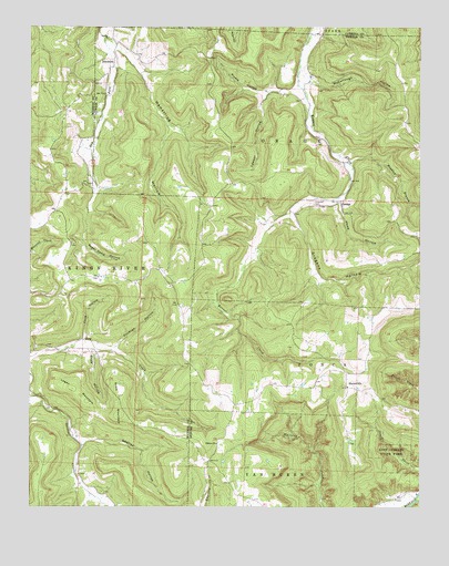
Osage SW, AR USGS Topographic Map
Click on map above to begin viewing in our Map Viewer.

This topographic map contains these locations and features:
Feature Name Type Latitude Longitude GNIS ID View Map
Allfriend (historical)Populated PlaceN36.1109°W93.4107°69914View Map
Arms MountainSummitN36.0242°W93.4707°57279View Map
Bee HollowValleyN36.1026°W93.3752°46303View Map
Bradley BranchStreamN36.0895°W93.3969°46890View Map
Bradshaw MountainSummitN36.0534°W93.4971°57426View Map
Cockran HollowValleyN36.0417°W93.4727°47881View Map
Cook HollowValleyN36.0023°W93.4805°71213View Map
Cook HollowValleyN36.0406°W93.4799°47978View Map
Cove HollowValleyN36.0440°W93.4830°48106View Map
DinsmorePopulated PlaceN36.1145°W93.4735°57658View Map
Eden FallsFallsN36.0176°W93.3874°81819View Map
Elkhorn ChurchChurchN36.0165°W93.4399°48855View Map
GeorgePopulated PlaceN36.0798°W93.4005°57807View Map
Grogans HollowValleyN36.0762°W93.4152°49686View Map
Hamstring HollowValleyN36.1204°W93.4732°49816View Map
Hopewell CemeteryCemeteryN36.0795°W93.4088°50305View Map
Howe HollowValleyN36.0790°W93.4007°50365View Map
Lawson HollowValleyN36.1079°W93.4238°51012View Map
Liberty ChurchChurchN36.1223°W93.4749°51108View Map
Logan MountainSummitN36.0309°W93.4860°58081View Map
Lost Valley Natural BridgeArchN36.0150°W93.3842°2571581View Map
McCullough HollowValleyN36.1106°W93.4099°51815View Map
Pickle HollowValleyN36.1090°W93.4160°53349View Map
Smelley HollowValleyN36.0162°W93.4830°54928View Map
StovervillePopulated PlaceN36.0312°W93.3982°58695View Map
Sugar Camp HollowValleyN36.0687°W93.4827°55294View Map
Township of OsageCivilN36.0903°W93.4110°69686View Map
Township of PoncaCivilN36.0262°W93.3848°69690View Map

Note: Coordinates in the location and feature list above are referenced to NAD83 datum.


Copyright (C) 2008-2025 Ryan Niemi / Sunset Dynamics ... All Rights Reserved