TopoQuest Logo
Do you find TopoQuest useful?
Help keep TopoQuest running and adding new maps/features by donating!
Bitcoin:  19c7KJd3qBynnjoSw5npx9KScwjBe4ifkT
Litecoin:  LXs6TkuXGGXo1vDsWCkWVdjQX94eUKd6ui
Home View Maps Find Maps Find Places Resources & Links


Witter, Arkansas Topographic Map

USGS Map Title: Witter, AR
USGS Map MRC: 35093H6
DRG (GeoTIFF) Download: o35093h6.tif


Neighboring USGS Topographic Map Quads:


  Hartwell, AR  
36093A7
 

  Huntsville, AR  
36093A6
 

  Kingston, AR  
36093A5
 

  Japton, AR  
35093H7
 

  Witter, AR  
35093H6
 

  Weathers, AR  
35093H5
 

  Saint Paul, AR  
35093G7
 

  Pettigrew, AR  
35093G6
 

  Boston, AR  
35093G5


Map MRC Location:

N36°
W94°
N36°
W93°
H8 H7 H6 H5 H4 H3 H2 H1
G8 G7 G6 G5 G4 G3 G2 G1
F8 F7 F6 F5 F4 F3 F2 F1
E8 E7 E6 E5 E4 E3 E2 E1
D8 D7 D6 D5 D4 D3 D2 D1
C8 C7 C6 C5 C4 C3 C2 C1
B8 B7 B6 B5 B4 B3 B2 B1
A8 A7 A6 A5 A4 A3 A2 A1
N35°
W94°
N35°
W93°

Witter, AR USGS 1:24K Topographic Map Preview:
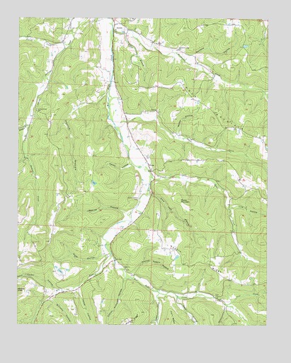
Witter, AR USGS Topographic Map
Click on map above to begin viewing in our Map Viewer.

This topographic map contains these locations and features:
Feature Name Type Latitude Longitude GNIS ID View Map
AuroraPopulated PlaceN35.9973°W93.7027°57294View Map
Captain Smiths CemeteryCemeteryN35.9265°W93.6899°47464View Map
Carroll Anderson HollowValleyN35.8892°W93.7196°71017View Map
Colder HollowValleyN35.8892°W93.7310°71190View Map
Cove CemeteryCemeteryN35.8867°W93.6510°48097View Map
Dry ForkStreamN35.9034°W93.7027°71455View Map
Ferrel CreekStreamN35.9884°W93.7257°71607View Map
Granny Paddin HollowValleyN35.8956°W93.6921°49554View Map
Harlow HollowValleyN35.9692°W93.7066°49862View Map
Henderson CreekStreamN35.9954°W93.7035°71960View Map
Henderson Creek CemeteryCemeteryN35.9878°W93.6705°50010View Map
Horn HollowValleyN35.8859°W93.6705°72075View Map
Hoxey HollowValleyN35.9404°W93.6935°50371View Map
Jackie HollowValleyN35.8862°W93.7313°72161View Map
Jackson Creek CemeteryCemeteryN35.9626°W93.7410°50570View Map
Jordan (historical)Populated PlaceN35.8995°W93.6671°66402View Map
Keck HollowValleyN35.9031°W93.7077°50773View Map
Kecks CreekStreamN35.9351°W93.6832°72236View Map
Lick HollowValleyN35.9226°W93.6421°72346View Map
Mitchell BranchStreamN35.9570°W93.7463°72700View Map
Moore MountainSummitN35.9256°W93.6694°58210View Map
Nubbin RidgeRidgeN35.9006°W93.6591°52859View Map
Ogden ChurchChurchN35.8987°W93.6969°52978View Map
Ogden CreekStreamN35.8879°W93.6791°72922View Map
Pennywinkle HollowValleyN35.8820°W93.6452°73041View Map
Pine CreekStreamN35.8834°W93.6449°73085View Map
Pollys BranchStreamN35.9945°W93.6991°53669View Map
Reeves HollowValleyN35.9204°W93.6957°53979View Map
Seals CreekStreamN35.9562°W93.7019°73506View Map
Slow Tom HollowValleyN35.9279°W93.6824°54918View Map
Township of BowenCivilN35.9780°W93.6855°68842View Map
Township of LincolnCivilN35.9044°W93.6870°68849View Map
Venquin (historical)Populated PlaceN35.9515°W93.7460°66416View Map
Washy HollowValleyN35.9642°W93.6602°56080View Map
Wetland HollowValleyN35.9845°W93.6652°56215View Map
Williams HollowValleyN35.8862°W93.7313°74164View Map
WitterPopulated PlaceN35.9376°W93.6835°78794View Map
Witter - Aurora Volunteer Fire DepartmentBuildingN35.9493°W93.6910°2117329View Map
Witter Post OfficePost OfficeN35.9423°W93.6856°2781909View Map

Note: Coordinates in the location and feature list above are referenced to NAD83 datum.


Copyright (C) 2008-2025 Ryan Niemi / Sunset Dynamics ... All Rights Reserved