TopoQuest Logo
Do you find TopoQuest useful?
Help keep TopoQuest running and adding new maps/features by donating!
Bitcoin:  19c7KJd3qBynnjoSw5npx9KScwjBe4ifkT
Litecoin:  LXs6TkuXGGXo1vDsWCkWVdjQX94eUKd6ui
Home View Maps Find Maps Find Places Resources & Links


Kingston, Arkansas Topographic Map

USGS Map Title: Kingston, AR
USGS Map MRC: 36093A5
DRG (GeoTIFF) Download: o36093a5.tif


Neighboring USGS Topographic Map Quads:


  Forum, AR  
36093B6
 

  Marble, AR  
36093B5
 

  Osage, AR  
36093B4
 

  Huntsville, AR  
36093A6
 

  Kingston, AR  
36093A5
 

  Osage SW, AR  
36093A4
 

  Witter, AR  
35093H6
 

  Weathers, AR  
35093H5
 

  Boxley, AR  
35093H4


Map MRC Location:

N37°
W94°
N37°
W93°
H8 H7 H6 H5 H4 H3 H2 H1
G8 G7 G6 G5 G4 G3 G2 G1
F8 F7 F6 F5 F4 F3 F2 F1
E8 E7 E6 E5 E4 E3 E2 E1
D8 D7 D6 D5 D4 D3 D2 D1
C8 C7 C6 C5 C4 C3 C2 C1
B8 B7 B6 B5 B4 B3 B2 B1
A8 A7 A6 A5 A4 A3 A2 A1
N36°
W94°
N36°
W93°

Kingston, AR USGS 1:24K Topographic Map Preview:
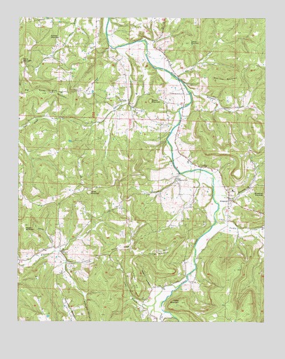
Kingston, AR USGS Topographic Map
Click on map above to begin viewing in our Map Viewer.

This topographic map contains these locations and features:
Feature Name Type Latitude Longitude GNIS ID View Map
Big Sandy ChurchChurchN36.0940°W93.6085°46593View Map
Big Sandy MountainSummitN36.0940°W93.6130°46594View Map
Boatright CreekStreamN36.1006°W93.5449°46785View Map
Dry CreekStreamN36.0390°W93.5032°48649View Map
Gusses CreekStreamN36.0040°W93.5505°71866View Map
Horine MountainSummitN36.1170°W93.6102°57944View Map
Jones MountainSummitN36.0531°W93.5893°57999View Map
KFAY-FM (Huntsville)TowerN36.0931°W93.6046°85201View Map
KingstonPopulated PlaceN36.0506°W93.5185°50874View Map
Kingston CemeteryCemeteryN36.0417°W93.5196°50876View Map
Kingston Elementary SchoolSchoolN36.0543°W93.5164°66403View Map
Kingston Fire DepartmentBuildingN36.0498°W93.5176°2116666View Map
Kingston High SchoolSchoolN36.0541°W93.5165°66404View Map
Kingston Post OfficePost OfficeN36.0508°W93.5188°2781873View Map
Long BranchStreamN36.0151°W93.5430°51411View Map
LoyPopulated PlaceN36.0145°W93.5524°58096View Map
Loy CemeteryCemeteryN36.0095°W93.5602°51508View Map
Maxwell CreekStreamN36.0523°W93.5260°51748View Map
Maxwell HollowValleyN36.0954°W93.5377°51750View Map
McArthur MountainSummitN36.0998°W93.5171°51775View Map
McKnight HollowValleyN36.0286°W93.6045°72610View Map
Negro MountainSummitN36.0398°W93.6221°52600View Map
Ozark Skies AirparkAirportN36.0017°W93.5697°2650712View Map
Parker-Boydston CemeteryCemeteryN36.0940°W93.5410°53192View Map
Parson HillSummitN36.0173°W93.5655°58330View Map
Patsy HollowValleyN36.0306°W93.6074°53217View Map
Phillips MountainSummitN36.0273°W93.5546°58361View Map
PurdyPopulated PlaceN36.0915°W93.5738°58446View Map
Purdy MountainSummitN36.0970°W93.5888°58447View Map
Reynolds MountainSummitN36.0081°W93.6007°73284View Map
Ribbon RidgeRidgeN36.0302°W93.5676°54004View Map
Rogers HollowValleyN36.0136°W93.5561°54166View Map
Round MountainSummitN36.0909°W93.5582°58542View Map
Slaven MountainSummitN36.1148°W93.5391°54902View Map
Spanker BranchStreamN36.1123°W93.5766°55053View Map
Sweden CreekStreamN36.0412°W93.5246°73795View Map
Tate HollowValleyN36.1018°W93.5450°66418View Map
Township of Kings RiverCivilN36.0378°W93.5087°68847View Map
Township of MarbleCivilN36.1235°W93.5954°68850View Map
Township of Purdy (historical)CivilN36.0848°W93.6155°68853View Map
Township of WhartonCivilN36.0174°W93.6045°1986189View Map
Township of Wharton CreekCivilN36.0167°W93.6241°68858View Map
Truth (historical)Populated PlaceN36.0937°W93.6238°66414View Map
Upper Campground CemeteryCemeteryN36.0587°W93.5449°55850View Map
Upper Wharton ChurchChurchN36.0290°W93.6035°55857View Map
Yates MountainSummitN36.0079°W93.5424°56585View Map

Note: Coordinates in the location and feature list above are referenced to NAD83 datum.


Copyright (C) 2008-2024 Ryan Niemi / Sunset Dynamics ... All Rights Reserved