TopoQuest Logo
Do you find TopoQuest useful?
Help keep TopoQuest running and adding new maps/features by donating!
Bitcoin:  19c7KJd3qBynnjoSw5npx9KScwjBe4ifkT
Litecoin:  LXs6TkuXGGXo1vDsWCkWVdjQX94eUKd6ui
Home View Maps Find Maps Find Places Resources & Links


Boxley, Arkansas Topographic Map

USGS Map Title: Boxley, AR
USGS Map MRC: 35093H4
DRG (GeoTIFF) Download: o35093h4.tif


Neighboring USGS Topographic Map Quads:


  Kingston, AR  
36093A5
 

  Osage SW, AR  
36093A4
 

  Ponca, AR  
36093A3
 

  Weathers, AR  
35093H5
 

  Boxley, AR  
35093H4
 

  Murray, AR  
35093H3
 

  Boston, AR  
35093G5
 

  Fallsville, AR  
35093G4
 

  Swain, AR  
35093G3


Map MRC Location:

N36°
W94°
N36°
W93°
H8 H7 H6 H5 H4 H3 H2 H1
G8 G7 G6 G5 G4 G3 G2 G1
F8 F7 F6 F5 F4 F3 F2 F1
E8 E7 E6 E5 E4 E3 E2 E1
D8 D7 D6 D5 D4 D3 D2 D1
C8 C7 C6 C5 C4 C3 C2 C1
B8 B7 B6 B5 B4 B3 B2 B1
A8 A7 A6 A5 A4 A3 A2 A1
N35°
W94°
N35°
W93°

Boxley, AR USGS 1:24K Topographic Map Preview:
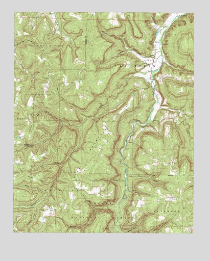
Boxley, AR USGS Topographic Map
Click on map above to begin viewing in our Map Viewer.

This topographic map contains these locations and features:
Feature Name Type Latitude Longitude GNIS ID View Map
Arrington CreekStreamN35.9729°W93.3968°70467View Map
Beech CreekStreamN35.9667°W93.4038°70612View Map
BoxleyPopulated PlaceN35.9767°W93.4021°70785View Map
Cave MountainSummitN35.9226°W93.4399°71044View Map
Cave Mountain ChurchChurchN35.9048°W93.4552°71046View Map
Dug HollowValleyN35.9042°W93.4224°48683View Map
Edgeman CreekStreamN35.9790°W93.4205°71531View Map
Edgemon CreekStreamN35.9351°W93.4541°71532View Map
Evans HollowValleyN35.8964°W93.4763°71571View Map
Fowler LakeReservoirN35.9536°W93.4161°79632View Map
Fowler Lake DamDamN35.9534°W93.4152°79631View Map
Hale HollowValleyN35.9136°W93.4670°71874View Map
Harve HollowValleyN35.9445°W93.4805°71927View Map
Hurricane RidgeRidgeN35.9226°W93.4752°72130View Map
Lewis HollowValleyN35.9373°W93.4671°72314View Map
Little Pine HollowValleyN35.8997°W93.4207°72413View Map
Lower Fork Whitaker CreekStreamN35.8884°W93.4430°72513View Map
Moore CreekStreamN35.9784°W93.3980°72721View Map
MossvillePopulated PlaceN35.8951°W93.3902°72744View Map
Mossville School (historical)SchoolN35.8951°W93.3843°69929View Map
Mountain View ChurchChurchN35.9381°W93.3993°72796View Map
Panther Camp HollowValleyN35.9412°W93.4502°72984View Map
Pine HollowValleyN35.9070°W93.4205°73093View Map
ReevesPopulated PlaceN35.9137°W93.4988°73270View Map
Reeves MountainSummitN35.9079°W93.4927°73273View Map
RykerPopulated PlaceN35.8881°W93.4735°73446View Map
Smith CreekStreamN35.9490°W93.3993°73619View Map
Township of KentuckyCivilN35.8789°W93.4672°69681View Map
Township of Van BurenCivilN35.9651°W93.4116°69694View Map
Walnut Grove ChurchChurchN35.9706°W93.4057°74000View Map
Walnut Grove School (historical)SchoolN35.9709°W93.4066°69944View Map
Whitaker CreekStreamN35.8895°W93.4266°74101View Map
Whiteley CemeteryCemeteryN35.9440°W93.3996°81835View Map
Whiteley CreekStreamN35.9965°W93.3888°74132View Map
Williams HollowValleyN35.8895°W93.4846°74163View Map

Note: Coordinates in the location and feature list above are referenced to NAD83 datum.


Copyright (C) 2008-2024 Ryan Niemi / Sunset Dynamics ... All Rights Reserved