TopoQuest Logo
Do you find TopoQuest useful?
Help keep TopoQuest running and adding new maps/features by donating!
Bitcoin:  19c7KJd3qBynnjoSw5npx9KScwjBe4ifkT
Litecoin:  LXs6TkuXGGXo1vDsWCkWVdjQX94eUKd6ui
Home View Maps Find Maps Find Places Resources & Links


Weaverville, California Topographic Map

USGS Map Title: Weaverville, CA
USGS Map MRC: 40122F8
DRG (GeoTIFF) Download: o40122f8.tif


Neighboring USGS Topographic Map Quads:


  Dedrick, CA  
40123G1
 

  Rush Creek Lakes, CA  
40122G8
 

  Trinity Dam, CA  
40122G7
 

  Junction City, CA  
40123F1
 

  Weaverville, CA  
40122F8
 

  Lewiston, CA  
40122F7
 

  Hayfork Summit, CA  
40123E1
 

  Hoosimbim Mountain, CA  
40122E8
 

  Bully Choop Mountain, CA  
40122E7


Map MRC Location:

N41°
W123°
N41°
W122°
H8 H7 H6 H5 H4 H3 H2 H1
G8 G7 G6 G5 G4 G3 G2 G1
F8 F7 F6 F5 F4 F3 F2 F1
E8 E7 E6 E5 E4 E3 E2 E1
D8 D7 D6 D5 D4 D3 D2 D1
C8 C7 C6 C5 C4 C3 C2 C1
B8 B7 B6 B5 B4 B3 B2 B1
A8 A7 A6 A5 A4 A3 A2 A1
N40°
W123°
N40°
W122°

Weaverville, CA USGS 1:24K Topographic Map Preview:
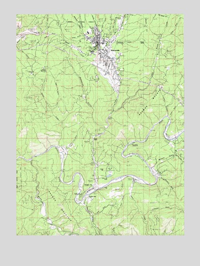
Weaverville, CA USGS Topographic Map
Click on map above to begin viewing in our Map Viewer.

This topographic map contains these locations and features:
Feature Name Type Latitude Longitude GNIS ID View Map
Anderson GulchValleyN40.6368°W122.9067°218259View Map
Ash HollowValleyN40.7385°W122.9442°218429View Map
Browns CreekStreamN40.6679°W122.9906°219903View Map
Browns MountainSummitN40.7021°W122.9020°257515View Map
California Highway Patrol WeavervilleBuildingN40.7231°W122.9288°2751106View Map
China GulchValleyN40.6926°W122.8884°221041View Map
China GulchValleyN40.7376°W122.9531°221043View Map
Democrat GulchValleyN40.6865°W122.9372°222256View Map
Douglas CityPopulated PlaceN40.6521°W122.9447°222556View Map
Douglas City CampgroundLocaleN40.6482°W122.9536°1665341View Map
Douglas City Census Designated PlaceCensusN40.6636°W122.9261°2582999View Map
Douglas City Elementary SchoolSchoolN40.6532°W122.9439°1683025View Map
Douglas City Fire DepartmentBuildingN40.6521°W122.9429°2622219View Map
Douglas City Post OfficePost OfficeN40.6518°W122.9439°1683026View Map
Dutton CreekStreamN40.6751°W122.9714°222784View Map
East Weaver CreekStreamN40.7213°W122.9403°233824View Map
Five Cent GulchValleyN40.7382°W122.9300°233885View Map
Garden GulchValleyN40.7418°W122.9422°224048View Map
Grant GulchValleyN40.6488°W122.9186°224423View Map
Grub GulchValleyN40.7379°W122.9695°224687View Map
Highland Art CenterBuildingN40.7326°W122.9400°1683038View Map
Indian CreekStreamN40.6582°W122.9145°225871View Map
Jesse GulchValleyN40.6360°W122.9450°226219View Map
La Grange MineMineN40.7410°W122.9906°226706View Map
Lance GulchValleyN40.7340°W122.9270°226841View Map
Last Chance GulchValleyN40.7490°W122.8909°226916View Map
Limeklin GulchValleyN40.6940°W122.8906°227112View Map
Little Browns CreekStreamN40.6954°W122.9303°234165View Map
Little CreekStreamN40.6265°W122.9611°227240View Map
Lonnie Pool Field/Weaverville AirportAirportN40.7480°W122.9220°1654111View Map
Lorenz GulchValleyN40.6735°W122.9628°252157View Map
Lowden ParkParkN40.7318°W122.9331°1665385View Map
McIntyre GulchValleyN40.6640°W122.9006°228382View Map
McKinzey GulchValleyN40.7396°W122.9534°234270View Map
Musser HillSummitN40.7435°W122.9059°229385View Map
Neaman GulchValleyN40.6560°W122.9236°229438View Map
Oregon MountainSummitN40.7193°W122.9817°230087View Map
Oregon Mountain SummitGapN40.7385°W122.9831°1665401View Map
Page GulchValleyN40.6963°W122.9742°230231View Map
Poker BarBarN40.6810°W122.8895°1665405View Map
Reading CreekStreamN40.6432°W122.9536°255020View Map
Readings BarLocaleN40.6432°W122.9492°231303View Map
River Meadows CampgroundLocaleN40.6499°W122.9472°1683054View Map
Rocky PointSummitN40.6785°W122.9414°1665415View Map
Shasta SpringSpringN40.7346°W122.9109°232877View Map
Sidney GulchValleyN40.7360°W122.9461°233080View Map
Steel Bridge CampgroundLocaleN40.6765°W122.9150°1665434View Map
Steiner FlatFlatN40.6724°W122.9675°235439View Map
Sweepstake FlatFlatN40.7154°W122.9936°235886View Map
Ten Cent GulchValleyN40.7382°W122.9395°236100View Map
The Church of Jesus Christ of Latter Day SaintsChurchN40.7315°W122.9470°1878531View Map
Trinity Alps Golf CourseLocaleN40.7188°W122.9303°1683060View Map
Trinity County CourthouseBuildingN40.7346°W122.9409°1683064View Map
Trinity County Law LibraryBuildingN40.7346°W122.9409°1683066View Map
Trinity County LibraryBuildingN40.7340°W122.9406°1683067View Map
Trinity County Life SupportBuildingN40.7332°W122.9319°2662207View Map
Trinity County Sheriff's OfficeBuildingN40.7368°W122.9475°2751031View Map
Trinity High SchoolSchoolN40.7395°W122.9480°276913View Map
Trinity HospitalHospitalN40.7381°W122.9397°1683068View Map
Union GulchValleyN40.7371°W122.8939°236794View Map
Union HillSummitN40.6618°W122.9359°1665451View Map
Union Hill MineMineN40.6610°W122.9320°236831View Map
Union Hill PondReservoirN40.6586°W122.9320°1665452View Map
Veterans Memorial HallBuildingN40.7365°W122.9467°1683069View Map
Vitzthum GulchValleyN40.6579°W122.8964°237118View Map
Weaver CreekStreamN40.6513°W122.9400°237373View Map
WeavervillePopulated PlaceN40.7310°W122.9420°1652649View Map
Weaverville CemeteryCemeteryN40.7307°W122.9456°1683072View Map
Weaverville Census Designated PlaceCensusN40.7488°W122.9274°2409537View Map
Weaverville Church of the NazareneChurchN40.7307°W122.9425°1878532View Map
Weaverville Elementary SchoolSchoolN40.7332°W122.9366°1683073View Map
Weaverville Historic DistrictParkN40.7332°W122.9409°1683074View Map
Weaverville Joss House State Historic ParkParkN40.7318°W122.9403°1683075View Map
Weaverville Post OfficePost OfficeN40.7334°W122.9426°1683076View Map
Weaverville Ranger District StationLocaleN40.7351°W122.9431°276914View Map
Weaverville Volunteer Fire DepartmentBuildingN40.7284°W122.9396°2621879View Map
West Weaver CreekStreamN40.7213°W122.9403°237538View Map

Note: Coordinates in the location and feature list above are referenced to NAD83 datum.


Copyright (C) 2008-2024 Ryan Niemi / Sunset Dynamics ... All Rights Reserved