TopoQuest Logo
Do you find TopoQuest useful?
Help keep TopoQuest running and adding new maps/features by donating!
Bitcoin:  19c7KJd3qBynnjoSw5npx9KScwjBe4ifkT
Litecoin:  LXs6TkuXGGXo1vDsWCkWVdjQX94eUKd6ui
Home View Maps Find Maps Find Places Resources & Links


Bonfield, Illinois Topographic Map

USGS Map Title: Bonfield, IL
USGS Map MRC: 41088B1
DRG (GeoTIFF) Download: o41088b1.tif


Neighboring USGS Topographic Map Quads:


  Wilmington, IL  
41088C2
 

  Symerton, IL  
41088C1
 

  Wilton Center, IL  
41087C8
 

  Essex, IL  
41088B2
 

  Bonfield, IL  
41088B1
 

  Bourbonnais, IL  
41087B8
 

  Buckingham, IL  
41088A2
 

  Herscher, IL  
41088A1
 

  West Kankakee, IL  
41087A8


Map MRC Location:

N42°
W89°
N42°
W88°
H8 H7 H6 H5 H4 H3 H2 H1
G8 G7 G6 G5 G4 G3 G2 G1
F8 F7 F6 F5 F4 F3 F2 F1
E8 E7 E6 E5 E4 E3 E2 E1
D8 D7 D6 D5 D4 D3 D2 D1
C8 C7 C6 C5 C4 C3 C2 C1
B8 B7 B6 B5 B4 B3 B2 B1
A8 A7 A6 A5 A4 A3 A2 A1
N41°
W89°
N41°
W88°

Bonfield, IL USGS 1:24K Topographic Map Preview:
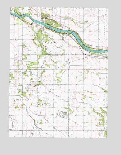
Bonfield, IL USGS Topographic Map
Click on map above to begin viewing in our Map Viewer.

This topographic map contains these locations and features:
Feature Name Type Latitude Longitude GNIS ID View Map
Beach CemeteryCemeteryN41.1978°W88.0526°413268View Map
Bertrand BranchStreamN41.1342°W88.0881°404231View Map
BonfieldPopulated PlaceN41.1467°W88.0578°404684View Map
Bonfield CemeteryCemeteryN41.1500°W88.0578°1810617View Map
Bonfield First United Methodist ChurchChurchN41.1475°W88.0550°1810618View Map
Bonfield Grade SchoolSchoolN41.1478°W88.0500°1810619View Map
Bonfield Post OfficePost OfficeN41.1466°W88.0569°2788356View Map
Classic LandingsAirportN41.1557°W88.0167°2679031View Map
Forked Bend FarmLocaleN41.2467°W88.0964°2566247View Map
FrielingsPopulated PlaceN41.1606°W88.1131°422714View Map
Hawker AirportAirportN41.1980°W88.0150°427415View Map
Hoffman IslandIslandN41.2328°W88.0789°410342View Map
Horse Lake (historical)LakeN41.1575°W88.1070°1810646View Map
Kankakee River State ParkParkN41.2095°W88.0306°411305View Map
Lehigh Raymond RunStreamN41.1375°W88.0928°411930View Map
Maple Grove CemeteryCemeteryN41.1618°W88.0452°412925View Map
McDowell Farm Post Office (historical)Post OfficeN41.1464°W88.0592°1810660View Map
North Bonfield BranchStreamN41.1636°W88.1098°403310View Map
Rayns CreekStreamN41.2353°W88.0837°416432View Map
Salina Post Office (historical)Post OfficeN41.1756°W88.0117°1810693View Map
Salina Township Fire Protection DistrictBuildingN41.1465°W88.0558°2682062View Map
Schreffler CemeteryCemeteryN41.1827°W88.0108°418475View Map
Smith IslandsIslandN41.2134°W88.0326°418637View Map
South Bonfield BranchStreamN41.1539°W88.1028°418718View Map
Terry CreekStreamN41.2364°W88.0953°419606View Map
Township of SalinaCivilN41.1612°W88.0691°429704View Map
Village of BonfieldCivilN41.1450°W88.0540°2398151View Map
Warner BridgeBridgeN41.2081°W88.0117°425621View Map
Wesley CemeteryCemeteryN41.2490°W88.0676°420763View Map

Note: Coordinates in the location and feature list above are referenced to NAD83 datum.


Copyright (C) 2008-2024 Ryan Niemi / Sunset Dynamics ... All Rights Reserved