TopoQuest Logo
Do you find TopoQuest useful?
Help keep TopoQuest running and adding new maps/features by donating!
Bitcoin:  19c7KJd3qBynnjoSw5npx9KScwjBe4ifkT
Litecoin:  LXs6TkuXGGXo1vDsWCkWVdjQX94eUKd6ui
Home View Maps Find Maps Find Places Resources & Links


West Kankakee, Illinois Topographic Map

USGS Map Title: West Kankakee, IL
USGS Map MRC: 41087A8
DRG (GeoTIFF) Download: o41087a8.tif


Neighboring USGS Topographic Map Quads:


  Bonfield, IL  
41088B1
 

  Bourbonnais, IL  
41087B8
 

  Bradley, IL  
41087B7
 

  Herscher, IL  
41088A1
 

  West Kankakee, IL  
41087A8
 

  Kankakee, IL  
41087A7
 

  Piper City NE, IL  
40088H1
 

  Clifton, IL  
40087H8
 

  L'Erable, IL  
40087H7


Map MRC Location:

N42°
W88°
N42°
W87°
H8 H7 H6 H5 H4 H3 H2 H1
G8 G7 G6 G5 G4 G3 G2 G1
F8 F7 F6 F5 F4 F3 F2 F1
E8 E7 E6 E5 E4 E3 E2 E1
D8 D7 D6 D5 D4 D3 D2 D1
C8 C7 C6 C5 C4 C3 C2 C1
B8 B7 B6 B5 B4 B3 B2 B1
A8 A7 A6 A5 A4 A3 A2 A1
N41°
W88°
N41°
W87°

West Kankakee, IL USGS 1:24K Topographic Map Preview:
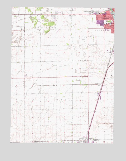
West Kankakee, IL USGS Topographic Map
Click on map above to begin viewing in our Map Viewer.

This topographic map contains these locations and features:
Feature Name Type Latitude Longitude GNIS ID View Map
Balthazor School (historical)SchoolN41.0900°W87.9556°1720089View Map
Beardsley School (historical)SchoolN41.0048°W87.9631°1720090View Map
Bird ParkParkN41.1217°W87.8784°404459View Map
Bracken School (historical)SchoolN41.0900°W87.9287°1720093View Map
ChebansePopulated PlaceN41.0031°W87.9081°406002View Map
Chebanse Post OfficePost OfficeN41.0015°W87.9100°2788612View Map
Devere School (historical)SchoolN41.0692°W87.8917°1720100View Map
Gar Creek DitchCanalN41.0995°W87.9000°408872View Map
GreenwichPopulated PlaceN41.1184°W87.9270°409450View Map
Hawkins School (historical)SchoolN41.1186°W87.9287°1720116View Map
Hillside ManorPopulated PlaceN41.1156°W87.9478°1810645View Map
Hillside Stock FarmLocaleN41.0036°W87.9778°2564390View Map
Imhauser School (historical)SchoolN41.0303°W87.9842°1720119View Map
IrwinPopulated PlaceN41.0523°W87.9839°410941View Map
John Kennedy Middle Grade SchoolSchoolN41.1131°W87.8856°420860View Map
Kankakee AirportAirportN41.0972°W87.9105°427410View Map
Kankakee Fire Department Station 5BuildingN41.1189°W87.8893°2682286View Map
Kankakee High SchoolSchoolN41.1050°W87.8856°1720122View Map
Kankakee Trinity AcademySchoolN41.1095°W87.8875°1810641View Map
Kingdom Hall of Jehovahs WitnessesChurchN41.1175°W87.8787°1962773View Map
Lehigh School (historical)SchoolN41.1036°W87.9967°1720129View Map
Limestone Fire Protection DistrictBuildingN41.1174°W87.9649°2682042View Map
North Irwin School (historical)SchoolN41.0670°W87.9839°1720137View Map
Open Bible CenterSchoolN41.1170°W87.8853°1810671View Map
OttoPopulated PlaceN41.0473°W87.8912°415236View Map
Otto Township Fire Protection DistrictBuildingN41.0026°W87.9097°2682336View Map
Porter School (historical)SchoolN41.0325°W87.9056°1720141View Map
Pratt School (historical)SchoolN41.0492°W87.9448°1720142View Map
Riverside Medical CenterHospitalN41.1250°W87.8821°1810676View Map
Riverside Medical Center HeliportAirportN41.1236°W87.8853°427412View Map
Saint James Catholic ChurchChurchN41.0542°W87.9845°1810687View Map
Saint James CemeteryCemeteryN41.0454°W87.9765°417328View Map
Saint John Reformed ChurchChurchN41.1150°W87.8792°1962781View Map
Saint Martin of Tours Roman Catholic ChurchChurchN41.1114°W87.8800°1962783View Map
Saint Martin of Tours SchoolSchoolN41.1114°W87.8800°1810689View Map
Small Memorial ParkParkN41.1128°W87.8787°1810698View Map
Snider's NurseryBuildingN41.1064°W87.8794°2634515View Map
Soldier CreekStreamN41.1217°W87.8764°418693View Map
Taft Primary SchoolSchoolN41.1106°W87.8845°1810701View Map
Township of OttoCivilN41.0394°W87.9253°429516View Map
Village of ChebanseCivilN41.0059°W87.9097°2397609View Map
Village of IrwinCivilN41.0537°W87.9841°2398278View Map
Village of LimestoneCivilN41.1187°W87.9560°2398440View Map
Wall Street Baptist ChurchChurchN41.1203°W87.8803°1962793View Map
West KankakeePopulated PlaceN41.1186°W87.8881°420861View Map
West Zion Church of the NazareneChurchN41.1142°W87.8887°1962795View Map
WLRT-FM (Kankakee)TowerN41.1228°W87.8931°428218View Map

Note: Coordinates in the location and feature list above are referenced to NAD83 datum.


Copyright (C) 2008-2025 Ryan Niemi / Sunset Dynamics ... All Rights Reserved