TopoQuest Logo
Do you find TopoQuest useful?
Help keep TopoQuest running and adding new maps/features by donating!
Bitcoin:  19c7KJd3qBynnjoSw5npx9KScwjBe4ifkT
Litecoin:  LXs6TkuXGGXo1vDsWCkWVdjQX94eUKd6ui
Home View Maps Find Maps Find Places Resources & Links


Shermans Dale, Pennsylvania Topographic Map

USGS Map Title: Shermans Dale, PA
USGS Map MRC: 40077C2
DRG (GeoTIFF) Download: o40077c2.tif


Neighboring USGS Topographic Map Quads:


  Ickesburg, PA  
40077D3
 

  Newport, PA  
40077D2
 

  Duncannon, PA  
40077D1
 

  Landisburg, PA  
40077C3
 

  Shermans Dale, PA  
40077C2
 

  Wertzville, PA  
40077C1
 

  Plainfield, PA  
40077B3
 

  Carlisle, PA  
40077B2
 

  Mechanicsburg, PA  
40077B1


Map MRC Location:

N41°
W78°
N41°
W77°
H8 H7 H6 H5 H4 H3 H2 H1
G8 G7 G6 G5 G4 G3 G2 G1
F8 F7 F6 F5 F4 F3 F2 F1
E8 E7 E6 E5 E4 E3 E2 E1
D8 D7 D6 D5 D4 D3 D2 D1
C8 C7 C6 C5 C4 C3 C2 C1
B8 B7 B6 B5 B4 B3 B2 B1
A8 A7 A6 A5 A4 A3 A2 A1
N40°
W78°
N40°
W77°

Shermans Dale, PA USGS 1:24K Topographic Map Preview:
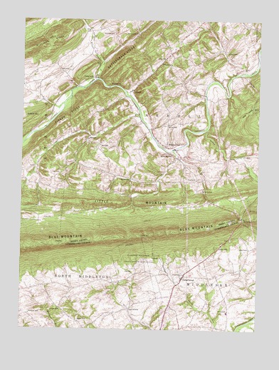
Shermans Dale, PA USGS Topographic Map
Click on map above to begin viewing in our Map Viewer.

This topographic map contains these locations and features:
Feature Name Type Latitude Longitude GNIS ID View Map
Airy View SchoolSchoolN40.3331°W77.1722°1214043View Map
Barn Hills SchoolSchoolN40.3112°W77.1922°1214045View Map
Carlisle SpringsPopulated PlaceN40.2709°W77.1644°1171217View Map
Carlisle Squadron 305 Civil Air Patrol Airport (historical)AirportN40.3334°W77.1747°1193942View Map
Carson Long CampLocaleN40.3487°W77.2030°1171270View Map
Cranes GapGapN40.2876°W77.1833°1172643View Map
Crums CornersPopulated PlaceN40.3618°W77.1714°1212656View Map
DromgoldPopulated PlaceN40.3462°W77.1916°1203448View Map
Evergreen SchoolSchoolN40.2581°W77.2294°1214065View Map
Falling SpringPopulated PlaceN40.3520°W77.2114°1203552View Map
Fishing RunStreamN40.3309°W77.1519°1174848View Map
Franklin Hall SchoolSchoolN40.2579°W77.1925°1214069View Map
Hamilton SchoolSchoolN40.2579°W77.1400°1176427View Map
Hamilton School (historical)SchoolN40.2579°W77.1400°1197248View Map
Lackeys SchoolSchoolN40.3595°W77.1744°1214075View Map
Longs GapGapN40.2840°W77.2291°1179920View Map
Middlesex Elementary SchoolSchoolN40.2570°W77.1397°1211733View Map
Middlesex Police DepartmentBuildingN40.2680°W77.1446°2754591View Map
Millers ChurchChurchN40.2831°W77.1447°1181242View Map
Milligan RidgeRidgeN40.3634°W77.2453°1181267View Map
Mount Gilead ChurchChurchN40.3570°W77.1711°1181689View Map
Mountainview Horse FarmLocaleN40.2669°W77.1772°2650577View Map
Perry Furnace RunStreamN40.3512°W77.2100°1183596View Map
Pine Grove SchoolSchoolN40.3623°W77.1425°1214088View Map
Pisgah ChurchChurchN40.3129°W77.2294°1183964View Map
Pisgah RidgeRidgeN40.3334°W77.2300°1183966View Map
Pisgah RunStreamN40.3365°W77.1875°1183967View Map
Pleasant Hall SchoolSchoolN40.2562°W77.2453°1214090View Map
Rattlesnake RidgeRidgeN40.3604°W77.1969°1184677View Map
Rocky HollowValleyN40.2945°W77.2109°1202646View Map
Saint Mathews ChurchChurchN40.2723°W77.1636°1186443View Map
Sandy Hollow ChurchChurchN40.3698°W77.1891°1186950View Map
Sandy Hollow SchoolSchoolN40.3693°W77.2011°1214096View Map
Shermans DalePopulated PlaceN40.3243°W77.1730°1187494View Map
Shermans Dale Ambulance AssociationBuildingN40.3112°W77.1496°2719582View Map
Shermans Dale Community Fire Company Station 12BuildingN40.3247°W77.1754°2645639View Map
Shermans Dale Post OfficePost OfficeN40.3207°W77.1648°2772978View Map
Shermans Dale SchoolSchoolN40.3212°W77.1703°1214097View Map
State Game Lands Number 230ParkN40.2834°W77.1830°1208065View Map
Sterretts GapGapN40.2954°W77.1333°1188617View Map
The Narrows SchoolSchoolN40.3062°W77.1550°1214104View Map
Township of CarrollCivilN40.3364°W77.1735°1216937View Map
Township of MiddlesexCivilN40.2502°W77.1356°1216339View Map
Union SchoolSchoolN40.3543°W77.2292°1214106View Map
Waggoner ChurchChurchN40.2531°W77.2189°1190464View Map
Warm SpringsSpringN40.3284°W77.2464°1202172View Map
Wolf ChurchChurchN40.3245°W77.2083°1191652View Map
Wolf SchoolSchoolN40.3270°W77.2144°1214110View Map
Yost Airport (historical)AirportN40.3301°W77.1772°1193935View Map
Youngs ChurchChurchN40.3109°W77.1569°1191917View Map

Note: Coordinates in the location and feature list above are referenced to NAD83 datum.


Copyright (C) 2008-2024 Ryan Niemi / Sunset Dynamics ... All Rights Reserved