TopoQuest Logo
Do you find TopoQuest useful?
Help keep TopoQuest running and adding new maps/features by donating!
Bitcoin:  19c7KJd3qBynnjoSw5npx9KScwjBe4ifkT
Litecoin:  LXs6TkuXGGXo1vDsWCkWVdjQX94eUKd6ui
Home View Maps Find Maps Find Places Resources & Links


Westby, Wisconsin Topographic Map

USGS Map Title: Westby, WI
USGS Map MRC: 43090F7
DRG (GeoTIFF) Download: o43090f7.tif


Neighboring USGS Topographic Map Quads:


  Middle Ridge, WI  
43090G8
 

  Melvina, WI  
43090G7
 

  Saint Marys, WI  
43090G6
 

  Esofea, WI  
43090F8
 

  Westby, WI  
43090F7
 

  Dell, WI  
43090F6
 

  Viroqua, WI  
43090E8
 

  Avalanche, WI  
43090E7
 

  La Farge, WI  
43090E6


Map MRC Location:

N44°
W91°
N44°
W90°
H8 H7 H6 H5 H4 H3 H2 H1
G8 G7 G6 G5 G4 G3 G2 G1
F8 F7 F6 F5 F4 F3 F2 F1
E8 E7 E6 E5 E4 E3 E2 E1
D8 D7 D6 D5 D4 D3 D2 D1
C8 C7 C6 C5 C4 C3 C2 C1
B8 B7 B6 B5 B4 B3 B2 B1
A8 A7 A6 A5 A4 A3 A2 A1
N43°
W91°
N43°
W90°

Westby, WI USGS 1:24K Topographic Map Preview:
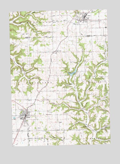
Westby, WI USGS Topographic Map
Click on map above to begin viewing in our Map Viewer.

This topographic map contains these locations and features:
Feature Name Type Latitude Longitude GNIS ID View Map
0.7 ReservoirReservoirN43.7233°W90.7935°1793311View Map
1 ReservoirReservoirN43.7116°W90.7518°1792427View Map
1 ReservoirReservoirN43.6966°W90.8735°1792429View Map
1 ReservoirReservoirN43.6800°W90.8668°1792431View Map
1 ReservoirReservoirN43.6800°W90.8501°1792433View Map
1 ReservoirReservoirN43.6883°W90.8401°1792435View Map
1 ReservoirReservoirN43.7500°W90.8618°1792364View Map
1 ReservoirReservoirN43.7433°W90.8418°1792366View Map
2 ReservoirReservoirN43.6600°W90.8001°1792461View Map
Bethesda CemeteryCemeteryN43.6461°W90.8143°1561647View Map
Bethesda Lutheran Brethren ChurchChurchN43.6569°W90.8596°1834438View Map
BloomingdalePopulated PlaceN43.6430°W90.7776°1561935View Map
Buckskin RidgeRidgeN43.6539°W90.8187°1834442View Map
CashtonPopulated PlaceN43.7419°W90.7793°1562772View Map
Cashton Elementary SchoolSchoolN43.7391°W90.7839°1846192View Map
Cashton Fire and RescueBuildingN43.7421°W90.7801°2697558View Map
Cashton High SchoolSchoolN43.7406°W90.7799°1846193View Map
Cashton Wastewater Treatment PlantLocaleN43.7469°W90.7861°2709821View Map
City of WestbyCivilN43.6529°W90.8584°1584402View Map
Clinton CemeteryCemeteryN43.7108°W90.7701°1563195View Map
Clinton RidgeRidgeN43.6980°W90.7826°1563197View Map
Clinton School (historical)SchoolN43.7108°W90.7707°1840860View Map
Clockmaker School (historical)SchoolN43.6686°W90.8293°1563199View Map
Coon Creek 14 D 6025 DamDamN43.6966°W90.8735°1792428View Map
Coon Creek 15 D 6025 DamDamN43.6800°W90.8668°1792430View Map
Coon Creek 16 D 6025 DamDamN43.6800°W90.8501°1792432View Map
Coon Creek 17 D 6025 DamDamN43.6883°W90.8401°1792434View Map
Coon Creek 21 D6025 DamDamN43.7316°W90.8418°1792369View Map
Coon Creek 23 D-6025 DamDamN43.7433°W90.8418°1792365View Map
Coon Creek 25 D-6025 DamDamN43.7500°W90.8618°1792363View Map
Coon Prairie Lutheran CemeteryCemeteryN43.6300°W90.8535°1951324View Map
Coon Prairie Lutheran ChurchChurchN43.6314°W90.8529°1563373View Map
Dickson BranchStreamN43.6569°W90.7835°1834450View Map
Eureka Maple Woods State Natural AreaParkN43.7386°W90.8707°2059239View Map
Gilbertson School (historical)SchoolN43.6383°W90.8296°1565519View Map
Goplin RidgeRidgeN43.6491°W90.7649°1565671View Map
Gronemus ValleyValleyN43.7040°W90.7525°1565912View Map
Hall CreekStreamN43.6358°W90.7682°1565985View Map
Homstad School (historical)SchoolN43.7111°W90.8199°1566647View Map
Immanuel ChurchChurchN43.7394°W90.8190°1566870View Map
Jersey ValleyValleyN43.6888°W90.7988°1567169View Map
Jersey Valley County ParkParkN43.6897°W90.7971°1834468View Map
Jersey Valley Lake 8ReservoirN43.6917°W90.7962°1792455View Map
Knapp CreekStreamN43.6639°W90.7874°1567562View Map
Knapp School (historical)SchoolN43.6794°W90.7757°1840867View Map
Knapp ValleyValleyN43.6645°W90.7872°1567566View Map
Larson RidgeRidgeN43.6339°W90.7849°1567863View Map
Living Waters CampLocaleN43.6808°W90.8035°1834475View Map
Luckasons Pond 3ReservoirN43.7309°W90.8409°1792370View Map
McElhose HillSummitN43.6883°W90.7624°1834480View Map
Mlsna D 2592.2 DamDamN43.7116°W90.7518°1792426View Map
Moen CemeteryCemeteryN43.7386°W90.8190°1569629View Map
Nelson HollowValleyN43.6419°W90.7507°1570160View Map
NewryPopulated PlaceN43.7116°W90.8174°1570261View Map
North Coon Prairie Lutheran ChurchChurchN43.7122°W90.8165°1834482View Map
Our Saviours CemeteryCemeteryN43.6680°W90.8529°1570949View Map
Our Saviours Lutheran ChurchChurchN43.6516°W90.8590°1834484View Map
Perkins HillSummitN43.6630°W90.7568°1834485View Map
Pleasant View CemeteryCemeteryN43.6539°W90.8248°1834488View Map
Portland Maples State Natural AreaParkN43.7441°W90.8596°2059241View Map
Rest Haven CemeteryCemeteryN43.7402°W90.8051°1572207View Map
Rongstad RidgeRidgeN43.7189°W90.8624°1572560View Map
Rongstad School (historical)SchoolN43.7183°W90.8504°1840872View Map
Sacred Heart CemeteryCemeteryN43.7486°W90.7701°1572781View Map
Sacred Heart Elementary SchoolSchoolN43.7469°W90.7772°2715824View Map
South Clinton SchoolSchoolN43.7282°W90.7555°2715845View Map
Town of ChristianaCivilN43.6846°W90.8497°1582960View Map
Village of CashtonCivilN43.7411°W90.7869°1582924View Map
Von Ruden G-8509 DamDamN43.7233°W90.7935°1793310View Map
Wang RidgeRidgeN43.6750°W90.7662°1576194View Map
West Fork Kickapoo 1 D 2592.2 DamDamN43.6883°W90.7985°1792454View Map
West Fork Kickapoo 16 D 2592.2 DamDamN43.6600°W90.8001°1792460View Map
West Fork Kickapoo 3 D 2592.2 DamDamN43.6733°W90.7501°1792448View Map
WestbyPopulated PlaceN43.6569°W90.8543°1576571View Map
Westby - Christiana Fire DistrictBuildingN43.6545°W90.8583°2698003View Map
Westby Coon Prairie Lutheran ChurchChurchN43.6497°W90.8601°1834502View Map
Westby Elementary SchoolSchoolN43.6479°W90.8647°2715684View Map
Westby High SchoolSchoolN43.6507°W90.8634°1834503View Map
Westby Middle SchoolSchoolN43.6507°W90.8634°2715852View Map
Westby Police DepartmentBuildingN43.6546°W90.8581°2759688View Map
Woodward School (historical)SchoolN43.7475°W90.8212°1846325View Map

Note: Coordinates in the location and feature list above are referenced to NAD83 datum.


Copyright (C) 2008-2024 Ryan Niemi / Sunset Dynamics ... All Rights Reserved