TopoQuest Logo
Do you find TopoQuest useful?
Help keep TopoQuest running and adding new maps/features by donating!
Bitcoin:  19c7KJd3qBynnjoSw5npx9KScwjBe4ifkT
Litecoin:  LXs6TkuXGGXo1vDsWCkWVdjQX94eUKd6ui
Home View Maps Find Maps Find Places Resources & Links


Whiskey Mountain, Oregon Topographic Map

USGS Map Title: Whiskey Mountain, OR
USGS Map MRC: 43119H4
DRG (GeoTIFF) Download: o43119h4.tif


Neighboring USGS Topographic Map Quads:


  Funny Butte, OR  
44119A5
 

  Izee, OR  
44119A4
 

  Lewis Creek, OR  
44119A3
 

  Big Mowich Mountain, OR  
43119H5
 

  Whiskey Mountain, OR  
43119H4
 

  Alsup Mountain, OR  
43119H3
 

  Donnelly Butte, OR  
43119G5
 

  Bear Canyon Butte, OR  
43119G4
 

  Hughet Valley, OR  
43119G3


Map MRC Location:

N44°
W120°
N44°
W119°
H8 H7 H6 H5 H4 H3 H2 H1
G8 G7 G6 G5 G4 G3 G2 G1
F8 F7 F6 F5 F4 F3 F2 F1
E8 E7 E6 E5 E4 E3 E2 E1
D8 D7 D6 D5 D4 D3 D2 D1
C8 C7 C6 C5 C4 C3 C2 C1
B8 B7 B6 B5 B4 B3 B2 B1
A8 A7 A6 A5 A4 A3 A2 A1
N43°
W120°
N43°
W119°

Whiskey Mountain, OR USGS 1:24K Topographic Map Preview:
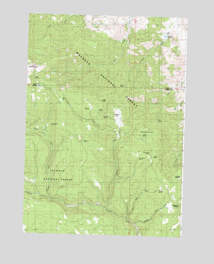
Whiskey Mountain, OR USGS Topographic Map
Click on map above to begin viewing in our Map Viewer.

This topographic map contains these locations and features:
Feature Name Type Latitude Longitude GNIS ID View Map
Alder SpringSpringN43.9321°W119.4079°1137098View Map
Bear Wallow SpringSpringN43.9371°W119.4800°1137773View Map
Ben Brown SpringSpringN43.9194°W119.4105°1137908View Map
Burnt Cabin CreekStreamN43.9218°W119.4780°1138983View Map
Clark SpringsSpringN43.9632°W119.4944°1139763View Map
Crowsfoot CreekStreamN43.8957°W119.4797°1140495View Map
Doorbell SpringSpringN43.9002°W119.3997°1154203View Map
Dry Well CreekStreamN43.8840°W119.4183°1141362View Map
Dry Well SpringSpringN43.9014°W119.3941°1141363View Map
French SpringSpringN43.9281°W119.4545°1142474View Map
Gay SpringSpringN43.9408°W119.3959°1142594View Map
Harrison SpringSpringN43.9468°W119.4496°1143335View Map
Jacks SpringSpringN43.9601°W119.4238°1144192View Map
Latigo CreekStreamN43.9321°W119.4266°1144857View Map
Lethas SpringSpringN43.9460°W119.4398°1144955View Map
Officers DamDamN43.9904°W119.3911°1155633View Map
Officers ReservoirReservoirN43.9890°W119.3921°1154201View Map
Rail CreekStreamN43.9621°W119.3788°1148146View Map
Schoolmam SpringSpringN43.9223°W119.4019°1149143View Map
Snow MountainSummitN43.9704°W119.4961°1149818View Map
Spring Valley CreekStreamN43.8813°W119.4119°1150197View Map
Spring Valley MeadowFlatN43.8923°W119.3853°1150198View Map
Taylor SpringSpringN43.9199°W119.3988°1150924View Map
Utley ButteSummitN43.9515°W119.4416°1151713View Map
Utley Creek TrailTrailN43.9529°W119.4347°1151715View Map
Vol SpringSpringN43.9512°W119.4715°1151784View Map
Whiskey CreekStreamN43.8888°W119.4333°1152184View Map
Whiskey FlatFlatN43.9429°W119.4272°1152189View Map
Whiskey MountainSummitN43.9346°W119.4094°1152194View Map
Whiskey SpringSpringN43.9426°W119.4352°1157006View Map

Note: Coordinates in the location and feature list above are referenced to NAD83 datum.


Copyright (C) 2008-2025 Ryan Niemi / Sunset Dynamics ... All Rights Reserved