TopoQuest Logo
Do you find TopoQuest useful?
Help keep TopoQuest running and adding new maps/features by donating!
Bitcoin:  19c7KJd3qBynnjoSw5npx9KScwjBe4ifkT
Litecoin:  LXs6TkuXGGXo1vDsWCkWVdjQX94eUKd6ui
Home View Maps Find Maps Find Places Resources & Links


White House, Tennessee Topographic Map

USGS Map Title: White House, TN
USGS Map MRC: 36086D6
DRG (GeoTIFF) Download: o36086d6.tif


Neighboring USGS Topographic Map Quads:


  Youngville, TN  
36086E7
 

  Orlinda, TN  
36086E6
 

  Portland, TN  
36086E5
 

  Greenbrier, TN  
36086D7
 

  White House, TN  
36086D6
 

  Cottontown, TN  
36086D5
 

  Whites Creek, TN  
36086C7
 

  Goodlettsville, TN  
36086C6
 

  Hendersonville, TN  
36086C5


Map MRC Location:

N37°
W87°
N37°
W86°
H8 H7 H6 H5 H4 H3 H2 H1
G8 G7 G6 G5 G4 G3 G2 G1
F8 F7 F6 F5 F4 F3 F2 F1
E8 E7 E6 E5 E4 E3 E2 E1
D8 D7 D6 D5 D4 D3 D2 D1
C8 C7 C6 C5 C4 C3 C2 C1
B8 B7 B6 B5 B4 B3 B2 B1
A8 A7 A6 A5 A4 A3 A2 A1
N36°
W87°
N36°
W86°

White House, TN USGS 1:24K Topographic Map Preview:
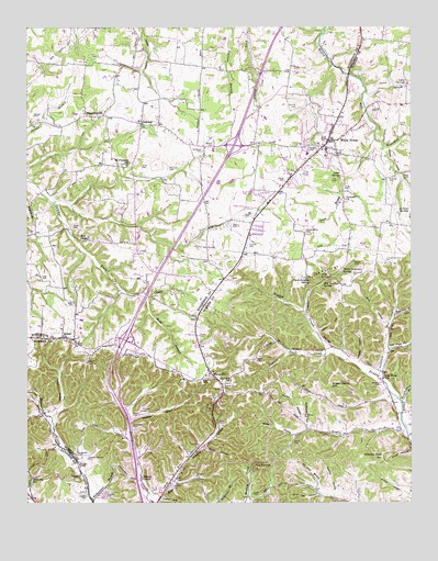
White House, TN USGS Topographic Map
Click on map above to begin viewing in our Map Viewer.

This topographic map contains these locations and features:
Feature Name Type Latitude Longitude GNIS ID View Map
Alden CemeteryCemeteryN36.4075°W86.6925°1275530View Map
Armstrong CemeteryCemeteryN36.4886°W86.6539°1644156View Map
Arterburn BranchStreamN36.4703°W86.6364°1275912View Map
BaggettsvillePopulated PlaceN36.4767°W86.7303°1276082View Map
Bentle CemeteryCemeteryN36.3909°W86.6630°1277029View Map
Bethel Baptist ChurchChurchN36.4189°W86.7383°1305150View Map
Bethel Baptist Church CemeteryCemeteryN36.4181°W86.7383°1646699View Map
Black Sulphur SpringSpringN36.4337°W86.6578°1277600View Map
Bloodworth CemeteryCemeteryN36.4073°W86.6850°1277703View Map
Brinkley CemeteryCemeteryN36.4603°W86.6319°1278407View Map
Bruce CemeteryCemeteryN36.3981°W86.7155°1278649View Map
Burney CemeteryCemeteryN36.4786°W86.6619°1279075View Map
Carter CemeteryCemeteryN36.4506°W86.6789°1279807View Map
Carter CemeteryCemeteryN36.4406°W86.6825°1644192View Map
Carver CemeteryCemeteryN36.4598°W86.6655°1305715View Map
Cawthon CemeteryCemeteryN36.4686°W86.6575°1279982View Map
City of MillersvilleCivilN36.3967°W86.7108°2404265View Map
City of White HouseCivilN36.4646°W86.6663°2405732View Map
Cole CemeteryCemeteryN36.4478°W86.6808°1280925View Map
Cole CemeteryCemeteryN36.4348°W86.7455°1306031View Map
Coleman-Raymon CemeteryCemeteryN36.3867°W86.7303°1280956View Map
Commissioner District 11CivilN36.3759°W86.6680°2464348View Map
Commissioner District 2CivilN36.4662°W86.6814°2463967View Map
Concord ChurchChurchN36.4548°W86.6464°1281071View Map
Doodle HollowValleyN36.3771°W86.6501°1282642View Map
Dorris CemeteryCemeteryN36.4126°W86.6754°1282652View Map
Echo HollowValleyN36.3896°W86.6922°1283491View Map
Eidson-White CemeteryCemeteryN36.4459°W86.6592°1283580View Map
First Baptist Church of White HouseChurchN36.4570°W86.6675°1320620View Map
First United Methodist Church of White HouseChurchN36.4742°W86.6506°1314252View Map
Fisher HollowValleyN36.3760°W86.7058°1284324View Map
Friendship Baptist ChurchChurchN36.3800°W86.7036°1314254View Map
Fulcher CemeteryCemeteryN36.3995°W86.7122°1285011View Map
Hampden CemeteryCemeteryN36.3881°W86.7339°1286693View Map
Happy ValleyValleyN36.4680°W86.6329°1286781View Map
Harold B Williams Elementary SchoolSchoolN36.4481°W86.6419°2454086View Map
Herrin HollowValleyN36.4202°W86.6550°1287502View Map
Hogan BranchStreamN36.3937°W86.6264°1287986View Map
Howell HollowValleyN36.4123°W86.6416°1288563View Map
Hudgins CemeteryCemeteryN36.3816°W86.6946°1288613View Map
Indian Trail CreekStreamN36.4142°W86.6497°1289003View Map
Interchange 104CrossingN36.4178°W86.7183°1310490View Map
Interchange 108CrossingN36.4692°W86.6825°1310491View Map
Jernigan CemeteryCemeteryN36.4684°W86.6933°1644323View Map
Jones BranchStreamN36.4598°W86.6464°1289704View Map
Jones CemeteryCemeteryN36.3775°W86.6767°1289756View Map
Jones CemeteryCemeteryN36.4575°W86.6464°1289762View Map
Jones CemeteryCemeteryN36.4637°W86.7125°1289763View Map
Jones CemeteryCemeteryN36.4767°W86.7478°1289766View Map
Jones SpringSpringN36.4612°W86.6475°1289823View Map
Lassiter CemeteryCemeteryN36.3769°W86.7244°1290660View Map
Lassiter CemeteryCemeteryN36.3770°W86.7303°1290661View Map
Latimer CemeteryCemeteryN36.4784°W86.6372°1290675View Map
Latimer SpringsSpringN36.4520°W86.6289°1290676View Map
Latimer-Johnson CemeteryCemeteryN36.4384°W86.6330°1290677View Map
Lee CemeteryCemeteryN36.4850°W86.6322°1290952View Map
Locke BranchStreamN36.4831°W86.6394°1291761View Map
Locke SpringsSpringN36.4851°W86.6263°1291767View Map
Martin HollowValleyN36.3946°W86.6589°1292843View Map
Mays CemeteryCemeteryN36.4170°W86.7339°1293032View Map
McMurtry CemeteryCemeteryN36.3984°W86.6597°1293429View Map
McMurtry HollowValleyN36.3960°W86.6592°1293430View Map
Merritt CemeteryCemeteryN36.4911°W86.6653°1644350View Map
Mill BranchStreamN36.4537°W86.7411°1652420View Map
Millersville Fire Department Station 1BuildingN36.3783°W86.7070°2653781View Map
Millersville Fire Department Station 2BuildingN36.4124°W86.7087°2654157View Map
Millersville Police DepartmentBuildingN36.3782°W86.7068°2765793View Map
Mims (historical)Populated PlaceN36.4242°W86.6306°1311943View Map
Moss BranchStreamN36.4531°W86.7358°1648502View Map
Moss CemeteryCemeteryN36.4886°W86.6736°1294498View Map
Mount Pleasant CemeteryCemeteryN36.4639°W86.7178°1644362View Map
Mount Pleasant SchoolSchoolN36.4639°W86.7172°1294788View Map
Mount Pleasant United Methodist ChurchChurchN36.4642°W86.7172°1314253View Map
Mud HollowValleyN36.4217°W86.6332°1295013View Map
Nelson CemeteryCemeteryN36.4062°W86.6853°1295376View Map
New Hope Baptist ChurchChurchN36.4075°W86.6350°1320672View Map
New Hope HollowValleyN36.4155°W86.6319°1295570View Map
New Hope SchoolSchoolN36.4075°W86.6339°1295575View Map
OakdalePopulated PlaceN36.4748°W86.7122°1296164View Map
Oil Well HollowValleyN36.3790°W86.6560°1296258View Map
Parm CemeteryCemeteryN36.4603°W86.6255°1296867View Map
Peaceful AcresPopulated PlaceN36.4395°W86.7153°1647345View Map
Pitt CemeteryCemeteryN36.4598°W86.6486°1297740View Map
Pleasant Grove United Methodist ChurchChurchN36.4764°W86.6472°1320680View Map
Ponds CemeteryCemeteryN36.4742°W86.6289°1298123View Map
Red Sulphur SpringSpringN36.4325°W86.6536°1299086View Map
Ridgetop SchoolSchoolN36.3817°W86.7481°1299407View Map
Robertson BranchStreamN36.4245°W86.6306°1299661View Map
Rocky CliffCliffN36.3859°W86.7319°1299879View Map
Rolling AcresPopulated PlaceN36.4473°W86.6750°1311954View Map
Rowland HollowValleyN36.3972°W86.7158°1300206View Map
Shallow Ford HillSummitN36.3873°W86.6344°1301208View Map
Shannon CemeteryCemeteryN36.4628°W86.7033°1301230View Map
Shipp HollowValleyN36.3930°W86.6630°1270129View Map
Slaters ChapelChurchN36.3814°W86.7125°1270480View Map
Strickland CemeteryCemeteryN36.4673°W86.6922°1271588View Map
Sugar Camp HillSummitN36.4062°W86.6517°1271643View Map
Swift CemeteryCemeteryN36.4475°W86.7350°1271987View Map
Templeton CemeteryCemeteryN36.3953°W86.7155°1272292View Map
The NarrowsGapN36.3845°W86.6733°1272426View Map
Thomas CemeteryCemeteryN36.4434°W86.6772°1272484View Map
Tri County Baptist ChurchChurchN36.4667°W86.6814°1644445View Map
Turpin CemeteryCemeteryN36.4189°W86.6939°1273101View Map
Turpin HollowValleyN36.4007°W86.7388°1273102View Map
Twin SpringsSpringN36.4337°W86.6531°1273127View Map
Tyree SpringsSpringN36.4353°W86.6506°1273155View Map
Tyree Springs (historical)Populated PlaceN36.4417°W86.6456°1645062View Map
Upchurch CemeteryCemeteryN36.4348°W86.6436°1273283View Map
Warren CemeteryCemeteryN36.4689°W86.6886°1273830View Map
Watkins CemeteryCemeteryN36.4059°W86.6353°1273907View Map
Webb BranchStreamN36.4289°W86.7108°1274008View Map
Webb CemeteryCemeteryN36.4278°W86.7347°1274020View Map
White HillPopulated PlaceN36.4098°W86.6906°1274370View Map
White Hill CemeteryCemeteryN36.4048°W86.6875°1646684View Map
White Hill Cemetery ChurchChurchN36.4050°W86.6875°1646685View Map
White Hill School (historical)SchoolN36.4070°W86.6867°1320724View Map
White HousePopulated PlaceN36.4703°W86.6514°1304522View Map
White House CemeteryCemeteryN36.4664°W86.6519°1646698View Map
White House Church of ChristChurchN36.4667°W86.6519°1320725View Map
White House City Fire DepartmentBuildingN36.4692°W86.6648°2653612View Map
White House City HallBuildingN36.4670°W86.6550°1320726View Map
White House City ParkParkN36.4695°W86.6625°1316520View Map
White House Community Volunteer Fire Department Station 51 HeadquartersBuildingN36.4281°W86.6904°2653780View Map
White House Elementary SchoolSchoolN36.4667°W86.6583°1644474View Map
White House High SchoolSchoolN36.4620°W86.6461°1320727View Map
White House Inn MuseumBuildingN36.4689°W86.6631°1316522View Map
White House LibraryBuildingN36.4689°W86.6631°1316521View Map
White House Middle SchoolSchoolN36.4678°W86.6525°1320728View Map
White House Middle SchoolSchoolN36.4308°W86.6883°2454141View Map
White House Police DepartmentBuildingN36.4657°W86.6479°2765740View Map
White House Post OfficePost OfficeN36.4702°W86.6722°1650493View Map
White House QuarryMineN36.4589°W86.6878°2633426View Map
White Sulphur SpringSpringN36.4359°W86.6469°1274406View Map
Widick CemeteryCemeteryN36.4973°W86.6578°1644461View Map
Wild Cat HollowValleyN36.3773°W86.6553°1274526View Map
Williamson BranchStreamN36.3759°W86.7289°1274721View Map
Woodchopping BranchStreamN36.4020°W86.6283°1275031View Map
Zion ChapelChurchN36.4445°W86.7325°1275358View Map

Note: Coordinates in the location and feature list above are referenced to NAD83 datum.


Copyright (C) 2008-2025 Ryan Niemi / Sunset Dynamics ... All Rights Reserved