TopoQuest Logo
Do you find TopoQuest useful?
Help keep TopoQuest running and adding new maps/features by donating!
Bitcoin:  19c7KJd3qBynnjoSw5npx9KScwjBe4ifkT
Litecoin:  LXs6TkuXGGXo1vDsWCkWVdjQX94eUKd6ui
Home View Maps Find Maps Find Places Resources & Links


Willeys, Illinois Topographic Map

USGS Map Title: Willeys, IL
USGS Map MRC: 39089E2
DRG (GeoTIFF) Download: o39089e2.tif


Neighboring USGS Topographic Map Quads:


  Grove City, IL  
39089F3
 

  Stonington, IL  
39089F2
 

  Macon West, IL  
39089F1
 

  Taylorville, IL  
39089E3
 

  Willeys, IL  
39089E2
 

  Assumption, IL  
39089E1
 

  Clarksdale, IL  
39089D3
 

  Owaneco, IL  
39089D2
 

  Pana, IL  
39089D1


Map MRC Location:

N40°
W90°
N40°
W89°
H8 H7 H6 H5 H4 H3 H2 H1
G8 G7 G6 G5 G4 G3 G2 G1
F8 F7 F6 F5 F4 F3 F2 F1
E8 E7 E6 E5 E4 E3 E2 E1
D8 D7 D6 D5 D4 D3 D2 D1
C8 C7 C6 C5 C4 C3 C2 C1
B8 B7 B6 B5 B4 B3 B2 B1
A8 A7 A6 A5 A4 A3 A2 A1
N39°
W90°
N39°
W89°

Willeys, IL USGS 1:24K Topographic Map Preview:
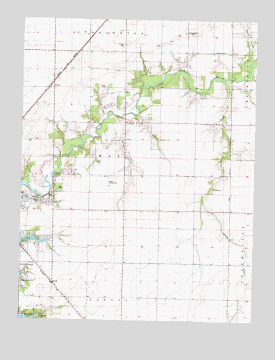
Willeys, IL USGS Topographic Map
Click on map above to begin viewing in our Map Viewer.

This topographic map contains these locations and features:
Feature Name Type Latitude Longitude GNIS ID View Map
Anselm Landing Strip (historical)AirportN39.5556°W89.2031°1747871View Map
Bertinetti LakeReservoirN39.5336°W89.2425°1691807View Map
Brown BranchStreamN39.6081°W89.1281°404934View Map
Brushy BranchStreamN39.5998°W89.1392°405047View Map
Brushy Branch School (historical)SchoolN39.5428°W89.1568°405049View Map
Callan FarmsLocaleN39.6095°W89.1690°2629390View Map
Fraley CemeteryCemeteryN39.5508°W89.2354°408646View Map
Harris Number 2 CemeteryCemeteryN39.5662°W89.2103°409842View Map
HewittvillePopulated PlaceN39.5362°W89.2168°424154View Map
Kim LakeLakeN39.5535°W89.2304°411468View Map
Kingdom HallChurchN39.5509°W89.2456°1747905View Map
Lin BranchStreamN39.5856°W89.1887°412108View Map
Long CemeteryCemeteryN39.5548°W89.1470°412557View Map
May TownhallBuildingN39.5750°W89.1945°1747911View Map
Myers LakeLakeN39.5492°W89.2403°414271View Map
Old StoningtonPopulated PlaceN39.6114°W89.1479°1747921View Map
Old Stonington CemeteryCemeteryN39.6196°W89.1581°415067View Map
Old Stonington ChurchChurchN39.6114°W89.1487°415068View Map
Pinefront FarmLocaleN39.5907°W89.1561°2629384View Map
Ponting CemeteryCemeteryN39.6147°W89.1962°419182View Map
SandersvillePopulated PlaceN39.6117°W89.1598°1811259View Map
Spring CreekStreamN39.5823°W89.2073°418931View Map
Tanner CemeteryCemeteryN39.5967°W89.2058°1747936View Map
Taylorville Correctional CenterBuildingN39.5146°W89.2286°2740105View Map
Township of MayCivilN39.5677°W89.1945°429342View Map
VelmaPopulated PlaceN39.5148°W89.2326°423275View Map
WilleysPopulated PlaceN39.5970°W89.2334°423311View Map

Note: Coordinates in the location and feature list above are referenced to NAD83 datum.


Copyright (C) 2008-2025 Ryan Niemi / Sunset Dynamics ... All Rights Reserved