TopoQuest Logo
Do you find TopoQuest useful?
Help keep TopoQuest running and adding new maps/features by donating!
Bitcoin:  19c7KJd3qBynnjoSw5npx9KScwjBe4ifkT
Litecoin:  LXs6TkuXGGXo1vDsWCkWVdjQX94eUKd6ui
Home View Maps Find Maps Find Places Resources & Links


Boscobel, Wisconsin Topographic Map

USGS Map Title: Boscobel, WI
USGS Map MRC: 43090B6
DRG (GeoTIFF) Download: o43090b6.tif


Neighboring USGS Topographic Map Quads:


  Gays Mills, WI  
43090C7
 

  Mount Zion, WI  
43090C6
 

  Boaz, WI  
43090C5
 

  Steuben, WI  
43090B7
 

  Boscobel, WI  
43090B6
 

  Blue River, WI  
43090B5
 

  Wauzeka East, WI  
43090A7
 

  Long Hollow, WI  
43090A6
 

  Castle Rock, WI  
43090A5


Map MRC Location:

N44°
W91°
N44°
W90°
H8 H7 H6 H5 H4 H3 H2 H1
G8 G7 G6 G5 G4 G3 G2 G1
F8 F7 F6 F5 F4 F3 F2 F1
E8 E7 E6 E5 E4 E3 E2 E1
D8 D7 D6 D5 D4 D3 D2 D1
C8 C7 C6 C5 C4 C3 C2 C1
B8 B7 B6 B5 B4 B3 B2 B1
A8 A7 A6 A5 A4 A3 A2 A1
N43°
W91°
N43°
W90°

Boscobel, WI USGS 1:24K Topographic Map Preview:
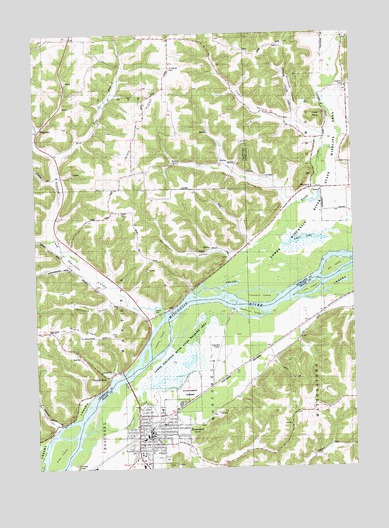
Boscobel, WI USGS Topographic Map
Click on map above to begin viewing in our Map Viewer.

This topographic map contains these locations and features:
Feature Name Type Latitude Longitude GNIS ID View Map
Allen IslandIslandN43.1305°W90.7426°1560775View Map
Big IslandIslandN43.1833°W90.6323°1561733View Map
BoscobelPopulated PlaceN43.1344°W90.7054°1562085View Map
Boscobel AirportAirportN43.1568°W90.6807°1581894View Map
Boscobel Elementary SchoolSchoolN43.1327°W90.7036°1958353View Map
Boscobel High SchoolSchoolN43.1296°W90.7030°1840475View Map
Boscobel Middle SchoolSchoolN43.1295°W90.7019°2715691View Map
Boscobel Police DepartmentBuildingN43.1346°W90.7061°2759620View Map
Boscobel Volunteer Fire Department and Rescue SquadBuildingN43.1387°W90.7062°2697867View Map
Boscobel Wastewater Treatment FacilityLocaleN43.1464°W90.7031°2709265View Map
Campbell School (historical)SchoolN43.1647°W90.7451°1846340View Map
Carlin DairyLocaleN43.2469°W90.6969°2709199View Map
Cedar PointCapeN43.2239°W90.6365°1562865View Map
Chitwood HollowValleyN43.2263°W90.6466°1563045View Map
Christ HollowValleyN43.1371°W90.7426°1563051View Map
City of BoscobelCivilN43.1432°W90.6965°1582843View Map
Clear LakeLakeN43.1775°W90.6740°1563147View Map
Coalburn School (historical)SchoolN43.2483°W90.7257°1846344View Map
Crooked CreekStreamN43.1258°W90.7387°1563537View Map
Dawsons Empire Stock and Dairy FarmLocaleN43.1953°W90.6565°1957706View Map
Dolans PavilionBuildingN43.1672°W90.7054°1846354View Map
Dremsa FarmLocaleN43.1806°W90.7331°2709200View Map
Easter RockPopulated PlaceN43.1511°W90.7210°1564389View Map
Feather IslandIslandN43.1622°W90.7004°1564895View Map
Flynn HollowValleyN43.1703°W90.6258°1565092View Map
Flynn School (historical)SchoolN43.1619°W90.6465°1840567View Map
Gobin HollowValleyN43.2195°W90.6367°1565593View Map
Grand Trunk FarmLocaleN43.2108°W90.6312°1957931View Map
Gundersen Boscobel Area Hospital and ClinicsHospitalN43.1334°W90.7086°2698480View Map
Harmony HillPopulated PlaceN43.2097°W90.7115°1846380View Map
Haskins CemeteryCemeteryN43.2347°W90.6273°1566120View Map
Haskins Church (historical)ChurchN43.2344°W90.6276°1840590View Map
Hildebrand Memorial LibraryBuildingN43.1342°W90.7056°2709182View Map
Hoover HollowValleyN43.2009°W90.6516°1566675View Map
Hoover Hollow School (historical)SchoolN43.2116°W90.6993°1846384View Map
Immaculate Conception SchoolSchoolN43.1378°W90.6996°1958354View Map
Irish RidgeRidgeN43.2172°W90.7118°1566953View Map
Knapp CreekStreamN43.1764°W90.6871°1567561View Map
Little IslandIslandN43.1753°W90.6426°1568285View Map
Lower LakeLakeN43.1905°W90.6447°1568739View Map
Maple Bluff Stock FarmLocaleN43.2200°W90.6607°1957932View Map
Maple RidgeRidgeN43.1647°W90.7487°1568997View Map
Maple Ridge Bible ChurchChurchN43.1641°W90.7451°1846405View Map
Marietta School (historical)SchoolN43.1825°W90.7360°1846407View Map
Marietta ValleyValleyN43.1692°W90.7002°1569037View Map
Memorial Hospital HeliportAirportN43.1333°W90.7079°1581895View Map
Patterson IslandIslandN43.1700°W90.6654°1571082View Map
Pleasant Valley Stock FarmLocaleN43.2269°W90.6310°1957934View Map
PlugtownPopulated PlaceN43.2225°W90.7485°1577774View Map
Rattlesnake PointSummitN43.1642°W90.7085°1846440View Map
Richland CreekStreamN43.1694°W90.6993°1572290View Map
Richwood Bottoms State Natural AreaParkN43.1780°W90.6571°1988949View Map
Rock Elm School (historical)SchoolN43.2489°W90.6960°1846443View Map
Saint Patrick CemeteryCemeteryN43.2397°W90.6957°1573393View Map
Saint Patrick Church (historical)ChurchN43.2400°W90.6960°1846450View Map
Sanders CreekStreamN43.1364°W90.7279°1573705View Map
Sky Hollow AirportAirportN43.2083°W90.6609°2444180View Map
Steele CemeteryCemeteryN43.1986°W90.7165°1574844View Map
Supermax Correctional Institution SchoolSchoolN43.1429°W90.6829°2715714View Map
Taylor HollowValleyN43.2335°W90.6273°1575272View Map
Town of BoscobelCivilN43.1264°W90.6888°1582844View Map
Town of ScottCivilN43.2488°W90.7256°1584116View Map
Tr Knapp Creek 1 ReservoirReservoirN43.2166°W90.6801°1793327View Map
Trumbull IslandIslandN43.1730°W90.6640°1575695View Map
Wannamaker HollowValleyN43.1853°W90.6739°1576199View Map
Wannamaker School (historical)SchoolN43.1922°W90.7012°1846483View Map
Wayne CemeteryCemeteryN43.1701°W90.7040°1576350View Map
WestportPopulated PlaceN43.2050°W90.6412°1577881View Map
Windward FarmsLocaleN43.2119°W90.6819°2709202View Map
Windward Farms G8915 DamDamN43.2166°W90.6801°1793326View Map
Wisconsin Secure Program FacilityBuildingN43.1430°W90.6831°2756165View Map
Woods School (historical)SchoolN43.2164°W90.6396°1840612View Map
Woodward HollowValleyN43.1728°W90.7205°1577042View Map

Note: Coordinates in the location and feature list above are referenced to NAD83 datum.


Copyright (C) 2008-2024 Ryan Niemi / Sunset Dynamics ... All Rights Reserved