TopoQuest Logo
Do you find TopoQuest useful?
Help keep TopoQuest running and adding new maps/features by donating!
Bitcoin:  19c7KJd3qBynnjoSw5npx9KScwjBe4ifkT
Litecoin:  LXs6TkuXGGXo1vDsWCkWVdjQX94eUKd6ui
Home View Maps Find Maps Find Places Resources & Links


Winchester, Indiana Topographic Map

USGS Map Title: Winchester, IN
USGS Map MRC: 40084B8
DRG (GeoTIFF) Download: o40084b8.tif


Neighboring USGS Topographic Map Quads:


  Ridgeville, IN  
40085C1
 

  Deerfield, IN  
40084C8
 

  Cosmos, OH  
40084C7
 

  Maxville, IN  
40085B1
 

  Winchester, IN  
40084B8
 

  Union City, IN  
40084B7
 

  Carlos, IN  
40085A1
 

  Lynn, IN  
40084A8
 

  Spartanburg, IN  
40084A7


Map MRC Location:

N41°
W85°
N41°
W84°
H8 H7 H6 H5 H4 H3 H2 H1
G8 G7 G6 G5 G4 G3 G2 G1
F8 F7 F6 F5 F4 F3 F2 F1
E8 E7 E6 E5 E4 E3 E2 E1
D8 D7 D6 D5 D4 D3 D2 D1
C8 C7 C6 C5 C4 C3 C2 C1
B8 B7 B6 B5 B4 B3 B2 B1
A8 A7 A6 A5 A4 A3 A2 A1
N40°
W85°
N40°
W84°

Winchester, IN USGS 1:24K Topographic Map Preview:
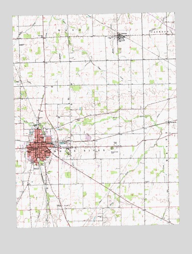
Winchester, IN USGS Topographic Map
Click on map above to begin viewing in our Map Viewer.

This topographic map contains these locations and features:
Feature Name Type Latitude Longitude GNIS ID View Map
Airline Twin Drive-InLocaleN40.1728°W84.9228°2558104View Map
City of WinchesterCivilN40.1719°W84.9766°2397335View Map
Clear Creek ChurchChurchN40.2370°W84.9769°432616View Map
Fountain Park CemeteryCemeteryN40.1617°W84.9790°434717View Map
Goodrich ParkParkN40.1820°W84.9777°435173View Map
Gospel ChurchChurchN40.1728°W84.9883°435235View Map
HarrisvillePopulated PlaceN40.1848°W84.8816°435807View Map
Hickory CreekStreamN40.2492°W84.9689°436099View Map
Jericho ChurchChurchN40.1500°W84.9002°436993View Map
Lee L Driver Junior High SchoolSchoolN40.1712°W84.9586°447144View Map
Moffitt CemeteryCemeteryN40.1878°W84.9519°439309View Map
Mount Zion ChurchChurchN40.1300°W84.9347°439766View Map
O R Baker Elementary SchoolSchoolN40.1662°W84.9761°430437View Map
Oliver P Morton Elementary SchoolSchoolN40.1775°W84.9777°439478View Map
Owl CreekStreamN40.1717°W84.8914°440808View Map
Peach CreekStreamN40.1806°W84.9580°449521View Map
Randolph County AirportAirportN40.1712°W84.9208°449391View Map
Randolph County Emergency Medical ServicesBuildingN40.1687°W84.9720°2719359View Map
Randolph County Sheriff's OfficeBuildingN40.1708°W84.9805°2758041View Map
Saint Vincent Randolph HospitalHospitalN40.1690°W84.9691°2660438View Map
Salt CreekStreamN40.1859°W84.9800°442942View Map
SaratogaPopulated PlaceN40.2370°W84.9183°443028View Map
Saratoga Airport (historical)AirportN40.2417°W84.9069°449336View Map
Saratoga CemeteryCemeteryN40.2364°W84.9233°443029View Map
Shelley DitchCanalN40.1823°W84.8777°443354View Map
Sugar CreekStreamN40.1862°W84.9889°444325View Map
Town of SaratogaCivilN40.2368°W84.9158°2396906View Map
Ward Township Volunteer Fire DepartmentBuildingN40.2378°W84.9184°2626621View Map
Ward-Jackson SchoolSchoolN40.2348°W84.9177°445467View Map
Wesleyan ChurchChurchN40.1887°W84.9822°445709View Map
White River Township Fire DepartmentBuildingN40.1785°W84.9808°2625936View Map
Willard Elementary SchoolSchoolN40.1695°W84.9883°446090View Map
WinchesterPopulated PlaceN40.1720°W84.9814°446166View Map
Winchester Community High SchoolSchoolN40.1695°W84.9772°447143View Map
Winchester Fire DepartmentBuildingN40.1729°W84.9807°2625772View Map
Winchester Police DepartmentBuildingN40.1730°W84.9807°2758388View Map
WZZY-FM (Winchester)TowerN40.1662°W84.9664°448992View Map

Note: Coordinates in the location and feature list above are referenced to NAD83 datum.


Copyright (C) 2008-2025 Ryan Niemi / Sunset Dynamics ... All Rights Reserved