TopoQuest Logo
Do you find TopoQuest useful?
Help keep TopoQuest running and adding new maps/features by donating!
Bitcoin:  19c7KJd3qBynnjoSw5npx9KScwjBe4ifkT
Litecoin:  LXs6TkuXGGXo1vDsWCkWVdjQX94eUKd6ui
Home View Maps Find Maps Find Places Resources & Links


Winterpock, Virginia Topographic Map

USGS Map Title: Winterpock, VA
USGS Map MRC: 37077C6
DRG (GeoTIFF) Download: o37077c6.tif


Neighboring USGS Topographic Map Quads:


  Clayville, VA  
37077D7
 

  Hallsboro, VA  
37077D6
 

  Chesterfield, VA  
37077D5
 

  Mannboro, VA  
37077C7
 

  Winterpock, VA  
37077C6
 

  Beach, VA  
37077C5
 

  Hebron, VA  
37077B7
 

  Church Road, VA  
37077B6
 

  Sutherland, VA  
37077B5


Map MRC Location:

N38°
W78°
N38°
W77°
H8 H7 H6 H5 H4 H3 H2 H1
G8 G7 G6 G5 G4 G3 G2 G1
F8 F7 F6 F5 F4 F3 F2 F1
E8 E7 E6 E5 E4 E3 E2 E1
D8 D7 D6 D5 D4 D3 D2 D1
C8 C7 C6 C5 C4 C3 C2 C1
B8 B7 B6 B5 B4 B3 B2 B1
A8 A7 A6 A5 A4 A3 A2 A1
N37°
W78°
N37°
W77°

Winterpock, VA USGS 1:24K Topographic Map Preview:
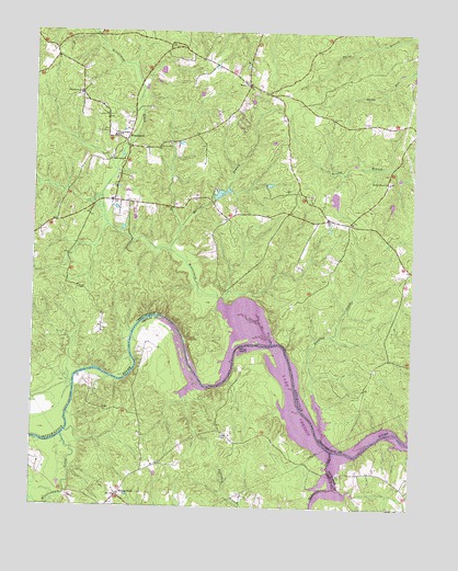
Winterpock, VA USGS Topographic Map
Click on map above to begin viewing in our Map Viewer.

This topographic map contains these locations and features:
Feature Name Type Latitude Longitude GNIS ID View Map
Bethia CemeteryCemeteryN37.3615°W77.6803°1760029View Map
Bethia ChurchChurchN37.3610°W77.6800°1463223View Map
Centenary CemeteryCemeteryN37.3476°W77.7225°1760039View Map
Centenary ChurchChurchN37.3476°W77.7225°1464666View Map
Chesterfield Fire and Emergency Medical Services Station 19 WinterpockBuildingN37.3594°W77.6683°2331871View Map
Clover HillBuildingN37.3549°W77.7114°1760049View Map
Coalboro (historical)Populated PlaceN37.3710°W77.7011°1760050View Map
Eppes Bridge (historical)BridgeN37.2818°W77.7361°1690519View Map
Eppes Falls (historical)Populated PlaceN37.2829°W77.7328°1690520View Map
Forkland Tavern (historical)BuildingN37.3260°W77.6530°1760065View Map
Goose IslandIslandN37.2935°W77.6808°1467257View Map
Holly (historical)Populated PlaceN37.3126°W77.6261°1760078View Map
Kcratchs DamDamN37.3318°W77.6530°1489504View Map
Kcratchs PondReservoirN37.3318°W77.6530°1489505View Map
Lake ChesdinReservoirN37.2776°W77.6623°1474230View Map
Lake Chesdin Golf ClubLocaleN37.2783°W77.6456°2520176View Map
Matoaca (historical)Populated PlaceN37.2738°W77.6389°1760093View Map
Matoaca DistrictCivilN37.3427°W77.6654°1927394View Map
Namozine CreekStreamN37.2621°W77.6489°1471315View Map
Nooning CreekStreamN37.2713°W77.6542°1471562View Map
Perdue (historical)Populated PlaceN37.3510°W77.6372°1760111View Map
Second Branch Baptist ChurchChurchN37.3357°W77.6330°1760129View Map
Second Branch Baptist Church CemeteryCemeteryN37.3360°W77.6326°1760130View Map
Second Branch SchoolSchoolN37.3357°W77.6333°1474139View Map
Sedley Baptist ChurchChurchN37.3056°W77.6456°2085940View Map
SummitPopulated PlaceN37.3613°W77.6797°1760138View Map
Surline BranchStreamN37.3174°W77.7050°1475347View Map
Tabernacle ChurchChurchN37.3415°W77.7239°1475429View Map
Vest DamDamN37.3318°W77.6897°1489503View Map
Whites StoreLocaleN37.2529°W77.7208°1476674View Map
WinterpockPopulated PlaceN37.3460°W77.7194°1500336View Map
Winterpock CreekStreamN37.2927°W77.6711°1476873View Map
Winterpock Elementary SchoolSchoolN37.3585°W77.7347°1476874View Map
Winterpock Station Number 19BuildingN37.3583°W77.6653°2075496View Map
Winticomack CreekStreamN37.2682°W77.7394°1476875View Map

Note: Coordinates in the location and feature list above are referenced to NAD83 datum.


Copyright (C) 2008-2024 Ryan Niemi / Sunset Dynamics ... All Rights Reserved