TopoQuest Logo
Do you find TopoQuest useful?
Help keep TopoQuest running and adding new maps/features by donating!
Bitcoin:  19c7KJd3qBynnjoSw5npx9KScwjBe4ifkT
Litecoin:  LXs6TkuXGGXo1vDsWCkWVdjQX94eUKd6ui
Home View Maps Find Maps Find Places Resources & Links


Wisconsin Dells North, Wisconsin Topographic Map

USGS Map Title: Wisconsin Dells North, WI
USGS Map MRC: 43089F7
DRG (GeoTIFF) Download: o43089f7.tif


Neighboring USGS Topographic Map Quads:


  Round Bluff, WI  
43089G8
 

  Easton, WI  
43089G7
 

  Brooks, WI  
43089G6
 

  Lyndon Station, WI  
43089F8
 

  Wisconsin Dells North, WI  
43089F7
 

  Big Spring, WI  
43089F6
 

  Reedsburg East, WI  
43089E8
 

  Wisconsin Dells South, WI  
43089E7
 

  Lewiston, WI  
43089E6


Map MRC Location:

N44°
W90°
N44°
W89°
H8 H7 H6 H5 H4 H3 H2 H1
G8 G7 G6 G5 G4 G3 G2 G1
F8 F7 F6 F5 F4 F3 F2 F1
E8 E7 E6 E5 E4 E3 E2 E1
D8 D7 D6 D5 D4 D3 D2 D1
C8 C7 C6 C5 C4 C3 C2 C1
B8 B7 B6 B5 B4 B3 B2 B1
A8 A7 A6 A5 A4 A3 A2 A1
N43°
W90°
N43°
W89°

Wisconsin Dells North, WI USGS 1:24K Topographic Map Preview:
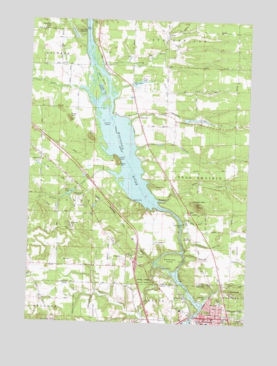
Wisconsin Dells North, WI USGS Topographic Map
Click on map above to begin viewing in our Map Viewer.

This topographic map contains these locations and features:
Feature Name Type Latitude Longitude GNIS ID View Map
Artist GlenValleyN43.6530°W89.7851°1560965View Map
Bethany Evangelical Lutheran ChurchChurchN43.6272°W89.7682°1842932View Map
Blackhawk IslandIslandN43.6500°W89.7932°1561898View Map
Blackhawk Island State Natural AreaParkN43.6508°W89.7929°2058605View Map
Calvary CemeteryCemeteryN43.6340°W89.7645°1562538View Map
Camp Dells CampgroundLocaleN43.7461°W89.8482°1562597View Map
Camp UphamLocaleN43.6472°W89.7979°1562666View Map
Camp WawbeekLocaleN43.6378°W89.7579°1562673View Map
City of Wisconsin DellsCivilN43.6337°W89.7752°1584462View Map
Clark IslandIslandN43.7255°W89.8354°1563116View Map
Coldwater CanyonValleyN43.6548°W89.7855°1563244View Map
Corning CreekStreamN43.7319°W89.8335°1563412View Map
Crandalls BayReservoirN43.6346°W89.7729°1563500View Map
Dells - Delton Emergency Medical Services Dells StationBuildingN43.6299°W89.7664°2698274View Map
Dells CampLocaleN43.7497°W89.8398°1563883View Map
Dells Christian AcademySchoolN43.6521°W89.7666°2715806View Map
Dells Raceway Park Emergency Medical ServicesBuildingN43.6752°W89.8462°2698449View Map
Dupless CemeteryCemeteryN43.6902°W89.8232°1564194View Map
Dutchman IslandsIslandN43.7080°W89.8287°1564218View Map
Elephants BackRidgeN43.6747°W89.7812°1564503View Map
Fawn LakeReservoirN43.7239°W89.8141°1564889View Map
Fawn Lake 3WR1011 DamDamN43.7236°W89.8165°1791844View Map
Fern Dell SchoolSchoolN43.6269°W89.7987°1564918View Map
Fox PointCapeN43.7028°W89.8418°1565225View Map
Gilmore CreekStreamN43.6853°W89.8248°1565541View Map
Grogan HeliportAirportN43.6272°W89.7851°1582276View Map
Gulch CreekStreamN43.6786°W89.7926°1565933View Map
Hulbert Creek Woods State Natural AreaParkN43.6319°W89.8283°2081926View Map
Indian Baptist CemeteryCemeteryN43.6533°W89.8171°1834304View Map
Indian Baptist ChurchChurchN43.6528°W89.8168°1566902View Map
Indian HeightsPopulated PlaceN43.6864°W89.8310°2741526View Map
Kilbourn DamDamN43.6268°W89.7816°1791670View Map
Kilbourn Fire DepartmentBuildingN43.6263°W89.7736°2697927View Map
Kilbourn Flowage 7746ReservoirN43.6266°W89.7818°1791671View Map
Lake LeeLakeN43.6378°W89.7684°1567932View Map
Louis BluffCliffN43.6922°W89.8237°1568695View Map
Lower DellsValleyN43.6265°W89.7811°1568723View Map
Lyndon CreekStreamN43.7200°W89.8426°1568842View Map
Native American ChurchChurchN43.6691°W89.8376°1570114View Map
Olin CemeteryCemeteryN43.7364°W89.8340°1570797View Map
Pine Aire Country ClubLocaleN43.6603°W89.7815°1581314View Map
PlainvillePopulated PlaceN43.7089°W89.8126°1577772View Map
Plainville CreekStreamN43.7080°W89.8182°1571584View Map
Rocky Arbor State ParkParkN43.6422°W89.8082°1572494View Map
Rogge BluffCliffN43.7094°W89.8526°1572542View Map
Roodes GlenValleyN43.6669°W89.7869°1572562View Map
Saint Cecelia Roman Catholic ChurchChurchN43.6253°W89.7735°1843018View Map
Saint Cecilia SchoolSchoolN43.6253°W89.7740°1572887View Map
Saint Paul Episcopal Church (historical)ChurchN43.6280°W89.7721°1843030View Map
Shadduck CreekStreamN43.6969°W89.8140°1573941View Map
Spring Grove CemeteryCemeteryN43.6263°W89.7528°1574652View Map
Stand RockPillarN43.6753°W89.8148°1574784View Map
Steamboat RockPillarN43.6658°W89.7871°1574840View Map
Swandas BluffCliffN43.7472°W89.8648°1575166View Map
The DellsValleyN43.6267°W89.7813°1577382View Map
The NarrowsGapN43.6511°W89.7851°1575335View Map
Town of Dell PrairieCivilN43.6928°W89.7560°1583071View Map
Town of LyndonCivilN43.6692°W89.8702°1583612View Map
Trinity Evangelical Lutheran ChurchChurchN43.6269°W89.7685°1843046View Map
Trinity Lutheran ChurchChurchN43.6272°W89.7685°1843047View Map
Trinity Lutheran SchoolSchoolN43.6269°W89.7688°2716479View Map
Trout CreekStreamN43.7222°W89.8232°1575661View Map
Trout LakeReservoirN43.6782°W89.8520°1575675View Map
Trout Lake DamDamN43.6794°W89.8487°1792168View Map
Twin Valley School (historical)SchoolN43.7439°W89.8135°1837608View Map
Upper DellsValleyN43.6395°W89.7836°1575958View Map
Wisconsin DellsPopulated PlaceN43.6275°W89.7710°1576900View Map
Wisconsin Dells Police DepartmentBuildingN43.6264°W89.7735°2759368View Map
Wisconsin Dells SpeedwayLocaleN43.6761°W89.8454°1581371View Map
Witches GulchValleyN43.6756°W89.8013°1576919View Map
Wood AirportAirportN43.7444°W89.8149°2444171View Map

Note: Coordinates in the location and feature list above are referenced to NAD83 datum.


Copyright (C) 2008-2024 Ryan Niemi / Sunset Dynamics ... All Rights Reserved