TopoQuest Logo
Do you find TopoQuest useful?
Help keep TopoQuest running and adding new maps/features by donating!
Bitcoin:  19c7KJd3qBynnjoSw5npx9KScwjBe4ifkT
Litecoin:  LXs6TkuXGGXo1vDsWCkWVdjQX94eUKd6ui
Home View Maps Find Maps Find Places Resources & Links


Witts Springs, Arkansas Topographic Map

USGS Map Title: Witts Springs, AR
USGS Map MRC: 35092G7
DRG (GeoTIFF) Download: o35092g7.tif


Neighboring USGS Topographic Map Quads:


  Eula, AR  
35092H8
 

  Snowball, AR  
35092H7
 

  Marshall, AR  
35092H6
 

  Moore, AR  
35092G8
 

  Witts Springs, AR  
35092G7
 

  Canaan, AR  
35092G6
 

  Smyrna, AR  
35092F8
 

  Tilly, AR  
35092F7
 

  Alread, AR  
35092F6


Map MRC Location:

N36°
W93°
N36°
W92°
H8 H7 H6 H5 H4 H3 H2 H1
G8 G7 G6 G5 G4 G3 G2 G1
F8 F7 F6 F5 F4 F3 F2 F1
E8 E7 E6 E5 E4 E3 E2 E1
D8 D7 D6 D5 D4 D3 D2 D1
C8 C7 C6 C5 C4 C3 C2 C1
B8 B7 B6 B5 B4 B3 B2 B1
A8 A7 A6 A5 A4 A3 A2 A1
N35°
W93°
N35°
W92°

Witts Springs, AR USGS 1:24K Topographic Map Preview:
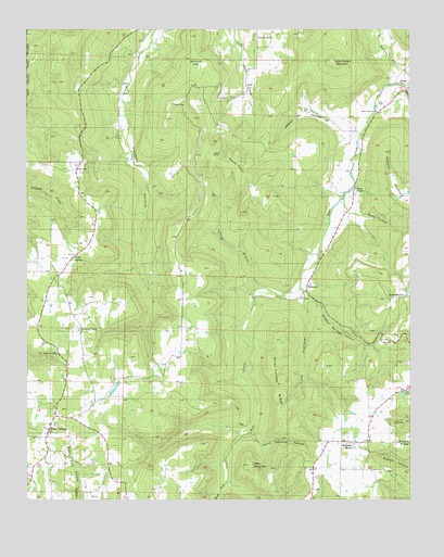
Witts Springs, AR USGS Topographic Map
Click on map above to begin viewing in our Map Viewer.

This topographic map contains these locations and features:
Feature Name Type Latitude Longitude GNIS ID View Map
Bear CreekPopulated PlaceN35.8315°W92.7682°76264View Map
Bear Creek CemeteryCemeteryN35.8542°W92.7602°70556View Map
Bear Creek ChurchChurchN35.8534°W92.7613°59397View Map
Bear MountainSummitN35.7590°W92.8018°70571View Map
BohannonPopulated PlaceN35.8062°W92.7841°59396View Map
Bohannon SchoolSchoolN35.8156°W92.7782°70757View Map
Bradley RidgeRidgeN35.7654°W92.7504°83867View Map
Burlston HollowValleyN35.8634°W92.7524°70928View Map
Chinquapin CemeteryCemeteryN35.8045°W92.7515°77528View Map
Church of ChristChurchN35.7890°W92.8652°59393View Map
Church of ChristChurchN35.7954°W92.8571°59394View Map
Cooper SchoolSchoolN35.8484°W92.7657°71226View Map
Cotton HollowValleyN35.8596°W92.7511°71237View Map
Deitrich FlatFlatN35.8690°W92.8210°76776View Map
Doins PointCliffN35.8387°W92.7996°71405View Map
Giles Turney RidgeRidgeN35.7881°W92.7929°71751View Map
Grassay Gap SchoolSchoolN35.8479°W92.8171°71810View Map
Happy Hollow SchoolSchoolN35.7606°W92.8102°71901View Map
Hensley FordCrossingN35.8598°W92.7538°71969View Map
Housley MountainSummitN35.8370°W92.7563°72093View Map
ImoPopulated PlaceN35.7787°W92.7507°77267View Map
Jenny Harness HollowValleyN35.7673°W92.8013°72180View Map
Lick HollowValleyN35.8045°W92.7868°72344View Map
Lick Owens MountainSummitN35.8663°W92.7754°72352View Map
Magic SpringsPopulated PlaceN35.8151°W92.8591°72539View Map
Piney BranchStreamN35.8062°W92.7974°73103View Map
Pleasant ChurchChurchN35.8715°W92.7996°73119View Map
Sulphur Spring BranchStreamN35.8062°W92.7857°69980View Map
Sulphur Springs HollowValleyN35.8051°W92.7846°73778View Map
Township of Mount PleasantCivilN35.7900°W92.8445°69088View Map
Township of Mount Vernon (historical)CivilN35.7751°W92.7516°69089View Map
Township of Sulphur Springs (historical)CivilN35.8167°W92.8002°69097View Map
Wassen HollowValleyN35.8479°W92.7674°74014View Map
Watts HollowValleyN35.8267°W92.7699°74026View Map
Welcome HomePopulated PlaceN35.7654°W92.7727°59395View Map
Welcome Home SchoolSchoolN35.7640°W92.7696°74045View Map
West Fork Bear CreekStreamN35.8062°W92.7857°83866View Map
Witts SpringsPopulated PlaceN35.7681°W92.8668°78795View Map
Witts Springs Elementary SchoolSchoolN35.7711°W92.8661°69984View Map
Witts Springs High SchoolSchoolN35.7704°W92.8660°69985View Map
Witts Springs Post OfficePost OfficeN35.7685°W92.8684°2781910View Map
Witts Springs Volunteer Fire DepartmentBuildingN35.7760°W92.8653°2117330View Map

Note: Coordinates in the location and feature list above are referenced to NAD83 datum.


Copyright (C) 2008-2024 Ryan Niemi / Sunset Dynamics ... All Rights Reserved