TopoQuest Logo
Do you find TopoQuest useful?
Help keep TopoQuest running and adding new maps/features by donating!
Bitcoin:  19c7KJd3qBynnjoSw5npx9KScwjBe4ifkT
Litecoin:  LXs6TkuXGGXo1vDsWCkWVdjQX94eUKd6ui
Home View Maps Find Maps Find Places Resources & Links


Snowball, Arkansas Topographic Map

USGS Map Title: Snowball, AR
USGS Map MRC: 35092H7
DRG (GeoTIFF) Download: o35092h7.tif


Neighboring USGS Topographic Map Quads:


  Western Grove, AR  
36092A8
 

  Saint Joe, AR  
36092A7
 

  Maumee, AR  
36092A6
 

  Eula, AR  
35092H8
 

  Snowball, AR  
35092H7
 

  Marshall, AR  
35092H6
 

  Moore, AR  
35092G8
 

  Witts Springs, AR  
35092G7
 

  Canaan, AR  
35092G6


Map MRC Location:

N36°
W93°
N36°
W92°
H8 H7 H6 H5 H4 H3 H2 H1
G8 G7 G6 G5 G4 G3 G2 G1
F8 F7 F6 F5 F4 F3 F2 F1
E8 E7 E6 E5 E4 E3 E2 E1
D8 D7 D6 D5 D4 D3 D2 D1
C8 C7 C6 C5 C4 C3 C2 C1
B8 B7 B6 B5 B4 B3 B2 B1
A8 A7 A6 A5 A4 A3 A2 A1
N35°
W93°
N35°
W92°

Snowball, AR USGS 1:24K Topographic Map Preview:
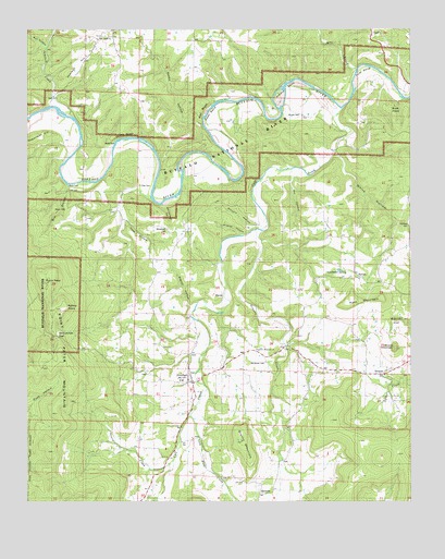
Snowball, AR USGS Topographic Map
Click on map above to begin viewing in our Map Viewer.

This topographic map contains these locations and features:
Feature Name Type Latitude Longitude GNIS ID View Map
Abbey CemeteryCemeteryN35.9786°W92.8719°70401View Map
Arnold BendBendN35.9834°W92.7904°70464View Map
Arnold CemeteryCemeteryN35.9773°W92.7902°70465View Map
Ben BranchStreamN35.9592°W92.8541°70620View Map
Ben HillSummitN35.9506°W92.8702°70623View Map
Bend FordCrossingN35.9592°W92.8618°70627View Map
BlancoPopulated PlaceN35.9287°W92.8121°76375View Map
Blanco HollowValleyN35.9267°W92.8221°70715View Map
Blanco SchoolSchoolN35.9390°W92.8235°70716View Map
Brown SchoolSchoolN35.9690°W92.7757°70847View Map
Buck PointCapeN35.9801°W92.7568°70896View Map
Bull HollowValleyN35.9959°W92.8713°70921View Map
BuroakPopulated PlaceN35.9345°W92.7666°59387View Map
Buroak SchoolSchoolN35.9362°W92.7685°70932View Map
Calf CreekStreamN35.9790°W92.7727°76495View Map
Cambell HollowValleyN35.8929°W92.8229°83865View Map
Cash BendBendN35.9776°W92.8160°71028View Map
DePriest CemeteryCemeteryN35.9481°W92.7504°48416View Map
DongolaPopulated PlaceN35.9087°W92.7585°71408View Map
Garrett Memorial ChurchChurchN35.9154°W92.8004°59386View Map
Gin HollowValleyN35.9620°W92.7885°71759View Map
Gourd CreekStreamN35.8876°W92.8266°71793View Map
Granny CreekStreamN35.9467°W92.7993°71800View Map
Granny MountainSummitN35.8912°W92.8054°71802View Map
Hage HollowValleyN35.9498°W92.8449°71872View Map
Jamison CreekStreamN35.9787°W92.8721°77364View Map
Jamison HillSummitN35.9909°W92.8582°72170View Map
Leadbetter SpringSpringN35.9360°W92.7713°72295View Map
Lick Fork CreekStreamN35.8973°W92.8227°72342View Map
Manes Town SchoolSchoolN35.9531°W92.8496°72545View Map
MarsenaPopulated PlaceN35.8804°W92.7946°72556View Map
McCutchen GapGapN35.9195°W92.8674°72588View Map
McDaniel CemeteryCemeteryN35.9123°W92.7974°77569View Map
Mill CreekStreamN35.9898°W92.7674°72668View Map
Pate MountainSummitN35.9273°W92.7707°73012View Map
Peter CaveLocaleN35.9648°W92.8035°73050View Map
Pine Bluff ChurchChurchN35.9976°W92.8541°77365View Map
Pine Bluff ChurchChurchN35.9970°W92.8521°74518View Map
Point PeterCliffN35.9376°W92.8691°73145View Map
Point Peter MountainSummitN35.9259°W92.8674°73373View Map
Red BluffCliffN35.9801°W92.8185°73246View Map
Rocky HollowValleyN35.9748°W92.8185°73363View Map
Rollins PointSummitN35.9265°W92.8641°79313View Map
Rollins PointCliffN35.9267°W92.8613°59384View Map
Round MountainSummitN35.9167°W92.7546°73410View Map
Shady Grove SchoolSchoolN35.9965°W92.8132°73522View Map
Sinyard HollowValleyN35.9490°W92.7979°73589View Map
Slay CemeteryCemeteryN35.9578°W92.8402°73605View Map
Slicker (historical)Populated PlaceN35.8770°W92.8349°69978View Map
Slicker SchoolSchoolN35.8776°W92.8354°73607View Map
SnowballPopulated PlaceN35.9065°W92.8218°78399View Map
Snowball Baptist ChurchChurchN35.9042°W92.8210°69979View Map
Snowball Fire StationBuildingN35.9069°W92.8250°2117133View Map
Snowball Post Office (historical)Post OfficeN35.9070°W92.8218°84513View Map
Township of Calf CreekCivilN35.9121°W92.8503°69083View Map
Township of Saint JoeCivilN35.9969°W92.8472°69094View Map
Tyler BendBendN35.9895°W92.7654°73929View Map
Whisenant CemeteryCemeteryN35.9473°W92.8293°59385View Map
Whisenant HollowValleyN35.9542°W92.8316°74096View Map
White BluffCliffN35.9715°W92.8416°74102View Map
White FordCrossingN35.9673°W92.8491°74109View Map
White HollowValleyN35.9684°W92.7749°74110View Map
Wildcat HollowValleyN35.9454°W92.8043°74148View Map
Zeb (historical)Populated PlaceN35.9390°W92.7682°69986View Map

Note: Coordinates in the location and feature list above are referenced to NAD83 datum.


Copyright (C) 2008-2024 Ryan Niemi / Sunset Dynamics ... All Rights Reserved