TopoQuest Logo
Do you find TopoQuest useful?
Help keep TopoQuest running and adding new maps/features by donating!
Bitcoin:  19c7KJd3qBynnjoSw5npx9KScwjBe4ifkT
Litecoin:  LXs6TkuXGGXo1vDsWCkWVdjQX94eUKd6ui
Home View Maps Find Maps Find Places Resources & Links


Wolcott, Colorado Topographic Map

USGS Map Title: Wolcott, CO
USGS Map MRC: 39106F6
DRG (GeoTIFF) Download: o39106f6.tif


Neighboring USGS Topographic Map Quads:


  Castle Peak, CO  
39106G7
 

  State Bridge, CO  
39106G6
 

  Lava Creek, CO  
39106G5
 

  Eagle, CO  
39106F7
 

  Wolcott, CO  
39106F6
 

  Edwards, CO  
39106F5
 

  The Seven Hermits, CO  
39106E7
 

  Fulford, CO  
39106E6
 

  Grouse Mountain, CO  
39106E5


Map MRC Location:

N40°
W107°
N40°
W106°
H8 H7 H6 H5 H4 H3 H2 H1
G8 G7 G6 G5 G4 G3 G2 G1
F8 F7 F6 F5 F4 F3 F2 F1
E8 E7 E6 E5 E4 E3 E2 E1
D8 D7 D6 D5 D4 D3 D2 D1
C8 C7 C6 C5 C4 C3 C2 C1
B8 B7 B6 B5 B4 B3 B2 B1
A8 A7 A6 A5 A4 A3 A2 A1
N39°
W107°
N39°
W106°

Wolcott, CO USGS 1:24K Topographic Map Preview:
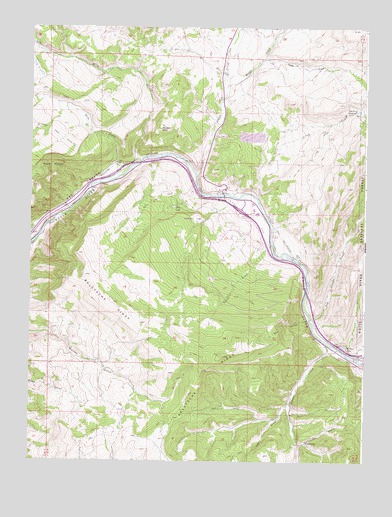
Wolcott, CO USGS Topographic Map
Click on map above to begin viewing in our Map Viewer.

This topographic map contains these locations and features:
Feature Name Type Latitude Longitude GNIS ID View Map
Alex Spring ReservoirReservoirN39.7209°W106.6250°197695View Map
Alkali CreekStreamN39.7080°W106.6892°175794View Map
Bear GulchValleyN39.6659°W106.6456°175871View Map
Bellyache RidgeRidgeN39.6553°W106.6781°202370View Map
Bocco MountainSummitN39.7208°W106.7025°175877View Map
Cache CreekStreamN39.7405°W106.6648°176260View Map
Cache Creek Access TrailTrailN39.7211°W106.6253°169395View Map
CartervillePopulated PlaceN39.6308°W106.6461°176264View Map
Cash DitchCanalN39.7205°W106.6375°202368View Map
CKP DitchCanalN39.6442°W106.6317°202327View Map
Dry GulchValleyN39.6300°W106.6495°175869View Map
Dry LakeLakeN39.6983°W106.6967°175874View Map
Eagle CountyCivilN39.6278°W106.6953°198134View Map
Eagle River Fire Protection District Cordillera - Chaveno Station 15BuildingN39.6296°W106.6456°2667086View Map
Eagle River Fire Protection District Cordillera - Summit Station 16BuildingN39.6259°W106.6891°2667087View Map
Eagle ValleyValleyN39.6589°W106.6393°175923View Map
Hells PocketBasinN39.7100°W106.7423°175876View Map
Horn RanchLocaleN39.7103°W106.7175°175875View Map
Lucky Strike Number One MineMineN39.6855°W106.6798°1684178View Map
Milk CreekStreamN39.7111°W106.7092°175793View Map
Muddy CreekStreamN39.7330°W106.6775°175799View Map
Oneill Holland DitchCanalN39.6947°W106.6673°175872View Map
Red Canyon CreekStreamN39.6661°W106.6453°176261View Map
Red Canyon Stock DrivewayTrailN39.6967°W106.6253°169394View Map
Red DrawValleyN39.6402°W106.6528°176262View Map
Rube CreekStreamN39.7069°W106.7178°175857View Map
Sherwood DitchCanalN39.7097°W106.7200°175879View Map
Spalding ReservoirReservoirN39.7261°W106.6280°176259View Map
Squaw CreekStreamN39.6589°W106.6386°176263View Map
Stag GulchValleyN39.6255°W106.6496°176075View Map
Travis CreekStreamN39.6872°W106.6606°175873View Map
Ute CreekStreamN39.7014°W106.6659°175878View Map
WilmorLocaleN39.6553°W106.6298°202369View Map
Wilmor LakeLakeN39.6581°W106.6328°175870View Map
WolcottPopulated PlaceN39.7028°W106.6786°204665View Map
Wolcott Census Designated PlaceCensusN39.7035°W106.6799°2583318View Map
Wolcott Post OfficePost OfficeN39.6980°W106.6655°2734598View Map

Note: Coordinates in the location and feature list above are referenced to NAD83 datum.


Copyright (C) 2008-2024 Ryan Niemi / Sunset Dynamics ... All Rights Reserved