TopoQuest Logo
Do you find TopoQuest useful?
Help keep TopoQuest running and adding new maps/features by donating!
Bitcoin:  19c7KJd3qBynnjoSw5npx9KScwjBe4ifkT
Litecoin:  LXs6TkuXGGXo1vDsWCkWVdjQX94eUKd6ui
Home View Maps Find Maps Find Places Resources & Links


Wolfe City, Texas Topographic Map

USGS Map Title: Wolfe City, TX
USGS Map MRC: 33096C1
DRG (GeoTIFF) Download: o33096c1.tif


Neighboring USGS Topographic Map Quads:


  Leonard, TX  
33096D2
 

  Gober, TX  
33096D1
 

  Ladonia, TX  
33095D8
 

  Celeste, TX  
33096C2
 

  Wolfe City, TX  
33096C1
 

  Commerce North, TX  
33095C8
 

  Greenville NW, TX  
33096B2
 

  Greenville NE, TX  
33096B1
 

  Commerce South, TX  
33095B8


Map MRC Location:

N34°
W97°
N34°
W96°
H8 H7 H6 H5 H4 H3 H2 H1
G8 G7 G6 G5 G4 G3 G2 G1
F8 F7 F6 F5 F4 F3 F2 F1
E8 E7 E6 E5 E4 E3 E2 E1
D8 D7 D6 D5 D4 D3 D2 D1
C8 C7 C6 C5 C4 C3 C2 C1
B8 B7 B6 B5 B4 B3 B2 B1
A8 A7 A6 A5 A4 A3 A2 A1
N33°
W97°
N33°
W96°

Wolfe City, TX USGS 1:24K Topographic Map Preview:
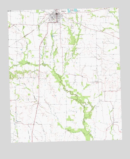
Wolfe City, TX USGS Topographic Map
Click on map above to begin viewing in our Map Viewer.

This topographic map contains these locations and features:
Feature Name Type Latitude Longitude GNIS ID View Map
AberfoylePopulated PlaceN33.3051°W96.0252°1350850View Map
Card AerodromeAirportN33.2614°W96.1156°1386769View Map
City of Wolfe CityCivilN33.3705°W96.0685°2412292View Map
Hall CemeteryCemeteryN33.3598°W96.1228°1358668View Map
Henington Airport (historical)AirportN33.3748°W96.0822°1387767View Map
Hickory CreekStreamN33.3251°W96.1116°1359119View Map
Honey CreekStreamN33.2571°W96.0377°1359493View Map
Honey Creek ChurchChurchN33.2926°W96.0930°1359505View Map
Hunt County Constable's Office Precinct 3BuildingN33.3708°W96.0694°2751424View Map
Kelly CemeteryCemeteryN33.3740°W96.0087°1360539View Map
Loring CreekStreamN33.3534°W96.1075°1361804View Map
Magee AirportAirportN33.3242°W96.0662°1387768View Map
Mount Carmel CemeteryCemeteryN33.3576°W96.0519°1363234View Map
Mynatt Field (historical)AirportN33.2698°W96.0225°1387565View Map
Onstot CemeteryCemeteryN33.2821°W96.0294°1364564View Map
Oyster CreekStreamN33.3179°W96.0747°1364660View Map
Short CreekStreamN33.3240°W96.0869°1368231View Map
Short CreekStreamN33.3240°W96.0875°1383676View Map
South SulphurPopulated PlaceN33.2651°W96.0100°1368776View Map
Spring CreekStreamN33.3246°W96.1019°1383376View Map
Spring CreekStreamN33.3246°W96.1016°1368978View Map
Turkey CreekStreamN33.3098°W96.0672°1370227View Map
Webb Hill ChurchChurchN33.3112°W96.1136°1370972View Map
Wesley Church CemeteryCemeteryN33.2873°W96.0236°1371051View Map
Westbrook CemeteryCemeteryN33.3682°W96.0889°1371293View Map
White RockPopulated PlaceN33.2690°W96.1191°1388223View Map
Wolfe CityPopulated PlaceN33.3707°W96.0689°1376856View Map
Wolfe City City HallBuildingN33.3705°W96.0702°2753261View Map
Wolfe City DivisionCivilN33.3406°W96.0620°1939336View Map
Wolfe City Elementary SchoolSchoolN33.3676°W96.0750°2006248View Map
Wolfe City High SchoolSchoolN33.3571°W96.0798°2006249View Map
Wolfe City Middle SchoolSchoolN33.3675°W96.0756°2006250View Map
Wolfe City Police DepartmentBuildingN33.3708°W96.0694°2751111View Map
Wolfe City Post OfficePost OfficeN33.3709°W96.0714°2732228View Map
Wolfe City ReservoirReservoirN33.3718°W96.0552°1855201View Map
Wolfe City Reservoir Number 1 DamDamN33.3718°W96.0552°1855200View Map
Wolfe City Reservoir Number 2ReservoirN33.3718°W96.0486°1855199View Map
Wolfe City Reservoir Number 2 DamDamN33.3718°W96.0486°1855198View Map
Wolfe City ReservoirsReservoirN33.3721°W96.0402°1383374View Map
Wolfe City ReservoirsReservoirN33.3749°W96.0489°1371872View Map
Wolfe City Volunteer Fire DepartmentBuildingN33.3700°W96.0697°2655329View Map

Note: Coordinates in the location and feature list above are referenced to NAD83 datum.


Copyright (C) 2008-2025 Ryan Niemi / Sunset Dynamics ... All Rights Reserved