TopoQuest Logo
Do you find TopoQuest useful?
Help keep TopoQuest running and adding new maps/features by donating!
Bitcoin:  19c7KJd3qBynnjoSw5npx9KScwjBe4ifkT
Litecoin:  LXs6TkuXGGXo1vDsWCkWVdjQX94eUKd6ui
Home View Maps Find Maps Find Places Resources & Links


Commerce South, Texas Topographic Map

USGS Map Title: Commerce South, TX
USGS Map MRC: 33095B8
DRG (GeoTIFF) Download: o33095b8.tif


Neighboring USGS Topographic Map Quads:


  Wolfe City, TX  
33096C1
 

  Commerce North, TX  
33095C8
 

  Klondike, TX  
33095C7
 

  Greenville NE, TX  
33096B1
 

  Commerce South, TX  
33095B8
 

  Cumby, TX  
33095B7
 

  Greenville SE, TX  
33096A1
 

  Lone Oak North, TX  
33095A8
 

  Miller Grove, TX  
33095A7


Map MRC Location:

N34°
W96°
N34°
W95°
H8 H7 H6 H5 H4 H3 H2 H1
G8 G7 G6 G5 G4 G3 G2 G1
F8 F7 F6 F5 F4 F3 F2 F1
E8 E7 E6 E5 E4 E3 E2 E1
D8 D7 D6 D5 D4 D3 D2 D1
C8 C7 C6 C5 C4 C3 C2 C1
B8 B7 B6 B5 B4 B3 B2 B1
A8 A7 A6 A5 A4 A3 A2 A1
N33°
W96°
N33°
W95°

Commerce South, TX USGS 1:24K Topographic Map Preview:
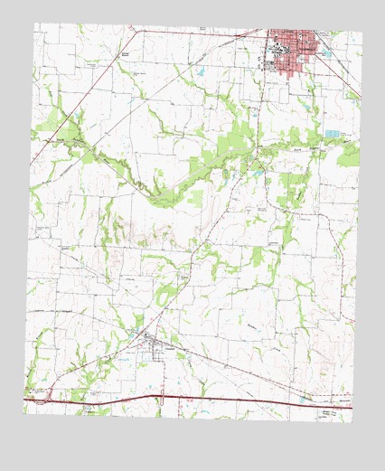
Commerce South, TX USGS Topographic Map
Click on map above to begin viewing in our Map Viewer.

This topographic map contains these locations and features:
Feature Name Type Latitude Longitude GNIS ID View Map
Adams LakeReservoirN33.2351°W95.9352°1855173View Map
Adams Lake DamDamN33.2351°W95.9352°1855172View Map
Bicentennial ParkParkN33.2323°W95.8861°2028783View Map
Brigham CemeteryCemeteryN33.1701°W95.9422°1331270View Map
CampbellPopulated PlaceN33.1482°W95.9514°1332031View Map
Campbell City HallBuildingN33.1483°W95.9562°2753265View Map
Campbell Post OfficePost OfficeN33.1484°W95.9580°2731221View Map
Campbell Volunteer Fire DepartmentBuildingN33.1497°W95.9519°2655430View Map
Church of ChristChurchN33.2376°W95.9208°2020822View Map
City of CampbellCivilN33.1465°W95.9545°2409972View Map
City of CommerceCivilN33.2422°W95.8994°2410211View Map
CommercePopulated PlaceN33.2471°W95.9000°1373171View Map
Commerce City HallBuildingN33.2499°W95.8991°2753229View Map
Commerce Fire DepartmentBuildingN33.2484°W95.8992°2655302View Map
Commerce High SchoolSchoolN33.2359°W95.8855°2006229View Map
Commerce Middle SchoolSchoolN33.2493°W95.8991°2006230View Map
Commerce Police DepartmentBuildingN33.2487°W95.8991°2751210View Map
Commerce Post OfficePost OfficeN33.2498°W95.8978°2732055View Map
Crosstimbers ChurchChurchN33.1809°W95.9086°1333732View Map
Dunbar CreekStreamN33.2118°W95.8925°1334765View Map
East Texas State CollegeSchoolN33.2443°W95.9066°1335007View Map
Friendship ChurchChurchN33.1265°W95.8877°1336244View Map
Hefley LakeReservoirN33.2051°W95.9102°1855171View Map
Hefley Lake DamDamN33.2051°W95.9102°1855170View Map
Hopkins Number 2 CemeteryCemeteryN33.1846°W95.9972°1338075View Map
Humboldt ChurchChurchN33.1787°W95.9869°1338292View Map
Hunt County Constable's Office Precinct 2BuildingN33.2366°W95.9084°2751323View Map
Hunt Regional Community Hospital at CommerceHospitalN33.2304°W95.8960°2015791View Map
KETR-FM (Commerce)TowerN33.2382°W95.9244°1385818View Map
Living Word Praise Chapel ChurchChurchN33.2457°W95.8994°2020848View Map
Louisiana and Arkansas Rr LakeReservoirN33.1333°W95.8933°1864653View Map
Louisiana and Arkansas Rr Lake DamDamN33.1333°W95.8933°1864652View Map
Presbyterian Hospital of Commerce HeliportAirportN33.2254°W95.8969°1386409View Map
Rays CreekStreamN33.2115°W95.9800°1375651View Map
Riley Grove ChurchChurchN33.2248°W95.9141°1345213View Map
Rosemound CemeteryCemeteryN33.2490°W95.8897°1345585View Map
Roundhouse PoolLakeN33.2473°W95.9002°1345704View Map
Saint Joseph Baptist ChurchChurchN33.2309°W95.8975°2020818View Map
Sand Hills Golf CourseLocaleN33.1926°W95.9141°1384478View Map
Scatter BranchPopulated PlaceN33.2398°W95.9686°1379038View Map
Scatter Branch CemeteryCemeteryN33.2348°W95.9625°1346750View Map
Shady Grove CemeteryCemeteryN33.1323°W95.9966°1346933View Map
Shiloh CemeteryCemeteryN33.1323°W95.9719°1347044View Map
Stewart CemeteryCemeteryN33.1896°W95.8977°1347916View Map
Texas A and M University - Commerce Campus Police DepartmentBuildingN33.2443°W95.9033°2751391View Map
Trinity Lutheran ChurchChurchN33.2473°W95.9030°2020837View Map

Note: Coordinates in the location and feature list above are referenced to NAD83 datum.


Copyright (C) 2008-2025 Ryan Niemi / Sunset Dynamics ... All Rights Reserved