TopoQuest Logo
Do you find TopoQuest useful?
Help keep TopoQuest running and adding new maps/features by donating!
Bitcoin:  19c7KJd3qBynnjoSw5npx9KScwjBe4ifkT
Litecoin:  LXs6TkuXGGXo1vDsWCkWVdjQX94eUKd6ui
Home View Maps Find Maps Find Places Resources & Links


Woodstock, Alabama Topographic Map

USGS Map Title: Woodstock, AL
USGS Map MRC: 33087B2
DRG (GeoTIFF) Download: o33087b2.tif


Neighboring USGS Topographic Map Quads:


  Brookwood, AL  
33087C3
 

  Abernant, AL  
33087C2
 

  McCalla, AL  
33087C1
 

  Coaling, AL  
33087B3
 

  Woodstock, AL  
33087B2
 

  Halfmile Shoals, AL  
33087B1
 

  Pearson, AL  
33087A3
 

  West Blocton West, AL  
33087A2
 

  West Blocton East, AL  
33087A1


Map MRC Location:

N34°
W88°
N34°
W87°
H8 H7 H6 H5 H4 H3 H2 H1
G8 G7 G6 G5 G4 G3 G2 G1
F8 F7 F6 F5 F4 F3 F2 F1
E8 E7 E6 E5 E4 E3 E2 E1
D8 D7 D6 D5 D4 D3 D2 D1
C8 C7 C6 C5 C4 C3 C2 C1
B8 B7 B6 B5 B4 B3 B2 B1
A8 A7 A6 A5 A4 A3 A2 A1
N33°
W88°
N33°
W87°

Woodstock, AL USGS 1:24K Topographic Map Preview:
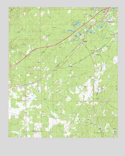
Woodstock, AL USGS Topographic Map
Click on map above to begin viewing in our Map Viewer.

This topographic map contains these locations and features:
Feature Name Type Latitude Longitude GNIS ID View Map
Academy ParkPopulated PlaceN33.2001°W87.1567°1959553View Map
Bama Rock GardenLocaleN33.2079°W87.2119°147831View Map
BanksPopulated PlaceN33.1515°W87.1892°1959555View Map
Banks CemeteryCemeteryN33.1518°W87.1969°138352View Map
Banks Chapel Baptist ChurchChurchN33.1518°W87.1883°138353View Map
Banks CreekStreamN33.1301°W87.2025°113448View Map
Banks SchoolSchoolN33.1518°W87.1886°113450View Map
Beaver PondLakeN33.2287°W87.1403°138354View Map
BibbvillePopulated PlaceN33.1935°W87.1764°156063View Map
Bibbville Baptist ChurchChurchN33.1921°W87.1783°154168View Map
Bibbville CemeteryCemeteryN33.1915°W87.1783°151018View Map
Big Bend (historical)LocaleN33.1979°W87.2472°147872View Map
Big Springs (historical)Populated PlaceN33.1637°W87.1492°138357View Map
Blake SchoolSchoolN33.1262°W87.1758°114473View Map
Blockton JuncPopulated PlaceN33.2090°W87.1433°156076View Map
Blue HoleLakeN33.2487°W87.1298°147886View Map
Blue PondReservoirN33.1905°W87.2157°147887View Map
Burmah (historical)Populated PlaceN33.1318°W87.1300°1959559View Map
Caffee CemeteryCemeteryN33.1646°W87.1542°1959560View Map
Caffee JunctionPopulated PlaceN33.2454°W87.1378°158836View Map
Caffee Junction ChurchChurchN33.2429°W87.1378°154793View Map
ChambersPopulated PlaceN33.2418°W87.1581°156164View Map
ChambleePopulated PlaceN33.2418°W87.1489°147961View Map
Clements CemeteryCemeteryN33.1362°W87.1933°138365View Map
DocrayPopulated PlaceN33.2237°W87.1656°117328View Map
DowdlePopulated PlaceN33.1810°W87.2100°156279View Map
Elgin (historical)LocaleN33.2459°W87.1531°148096View Map
Enterprise SchoolSchoolN33.1712°W87.1819°118010View Map
Faith Bible ChurchChurchN33.2029°W87.2267°148117View Map
Gaffney BranchStreamN33.2101°W87.2442°118777View Map
Gallant LakeLakeN33.2275°W87.1795°152561View Map
GilesPopulated PlaceN33.2315°W87.1508°118952View Map
Giles LakeLakeN33.2312°W87.1553°138373View Map
Grace Bible ChurchChurchN33.2121°W87.1608°148923View Map
Greeley Church (historical)ChurchN33.2429°W87.1378°148194View Map
Green PondPopulated PlaceN33.2251°W87.1264°155084View Map
Green Pond Baptist ChurchChurchN33.2215°W87.1261°148924View Map
Green Pond Christian SchoolSchoolN33.2212°W87.1261°148925View Map
Green Pond Post OfficePost OfficeN33.2236°W87.1262°169004View Map
Green Pond Volunteer Fire Department Station 1BuildingN33.2184°W87.1296°2682654View Map
Green Pond Volunteer Fire Department Station 2BuildingN33.2275°W87.1610°2683246View Map
Hickory Hill CemeteryCemeteryN33.1326°W87.1297°138377View Map
Hillcrest CemeteryCemeteryN33.1298°W87.1283°138379View Map
Holiday BeachParkN33.2223°W87.1722°148237View Map
Holiday RacewayLocaleN33.2223°W87.1667°148238View Map
Hopewell CemeteryCemeteryN33.1968°W87.2167°159027View Map
Hopewell ChurchChurchN33.1921°W87.2269°155524View Map
Houston MineMineN33.2496°W87.1281°167396View Map
Interchange 97CrossingN33.2496°W87.1347°155719View Map
Johnson CreekStreamN33.1623°W87.1494°120947View Map
Martaban MineMineN33.2434°W87.1297°167398View Map
McMicken LakeReservoirN33.2424°W87.1534°157834View Map
Miller LakeLakeN33.2312°W87.1461°138385View Map
Mount Carmel Baptist ChurchChurchN33.1321°W87.1297°152409View Map
Mount Carmel CemeteryCemeteryN33.1312°W87.1303°1959576View Map
Mount Gillard CemeteryCemeteryN33.1640°W87.2297°157864View Map
Mount Moriah Baptist ChurchChurchN33.1421°W87.1961°152446View Map
Mount Olive Baptist ChurchChurchN33.1393°W87.1536°138387View Map
Mount Olive ChurchChurchN33.1387°W87.1536°123309View Map
Mount Union SchoolSchoolN33.2221°W87.2058°123407View Map
Mud Lake DamDamN33.2268°W87.1833°131324View Map
North BibbPopulated PlaceN33.2040°W87.1531°1744605View Map
North Bibb Church of ChristChurchN33.1923°W87.1519°149510View Map
Reno ChurchChurchN33.2468°W87.1389°148476View Map
Robinson LakeReservoirN33.1835°W87.1300°131278View Map
Robinson Lake DamDamN33.1835°W87.1300°131277View Map
ShawtownPopulated PlaceN33.1385°W87.1528°1959578View Map
Sherrod (historical)LocaleN33.1732°W87.2444°148548View Map
Shuttlesworth CemeteryCemeteryN33.1607°W87.2089°148553View Map
Thomas BranchStreamN33.2007°W87.2275°127859View Map
Thrasher CemeteryCemeteryN33.1740°W87.1603°138403View Map
Town of VanceCivilN33.1747°W87.2314°2406787View Map
Town of WoodstockCivilN33.2195°W87.1488°2406913View Map
Union CemeteryCemeteryN33.2229°W87.2094°148676View Map
Union Cumberland ChurchChurchN33.2223°W87.2078°148678View Map
VancePopulated PlaceN33.1743°W87.2336°158947View Map
Vance Baptist ChurchChurchN33.1721°W87.2342°148921View Map
Vance Elementary SchoolSchoolN33.1757°W87.2394°148699View Map
Vance Police DepartmentBuildingN33.1753°W87.2336°2751796View Map
Vance Post OfficePost OfficeN33.1774°W87.2257°169214View Map
Vance Volunteer Fire Department Station 1BuildingN33.1753°W87.2336°2682787View Map
Woodland LakeLakeN33.2342°W87.1718°117329View Map
WoodstockPopulated PlaceN33.2068°W87.1500°129218View Map
Woodstock Baptist ChurchChurchN33.2073°W87.1483°148926View Map
Woodstock JunctionPopulated PlaceN33.2154°W87.1653°163227View Map
Woodstock Post OfficePost OfficeN33.2141°W87.1623°169006View Map
Woodstock SchoolSchoolN33.2121°W87.1378°138411View Map
Woodstock United Methodist ChurchChurchN33.2071°W87.1483°148927View Map
Woodward MineMineN33.2251°W87.1689°167397View Map

Note: Coordinates in the location and feature list above are referenced to NAD83 datum.


Copyright (C) 2008-2025 Ryan Niemi / Sunset Dynamics ... All Rights Reserved