TopoQuest Logo
Do you find TopoQuest useful?
Help keep TopoQuest running and adding new maps/features by donating!
Bitcoin:  19c7KJd3qBynnjoSw5npx9KScwjBe4ifkT
Litecoin:  LXs6TkuXGGXo1vDsWCkWVdjQX94eUKd6ui
Home View Maps Find Maps Find Places Resources & Links


West Blocton West, Alabama Topographic Map

USGS Map Title: West Blocton West, AL
USGS Map MRC: 33087A2
DRG (GeoTIFF) Download: o33087a2.tif


Neighboring USGS Topographic Map Quads:


  Coaling, AL  
33087B3
 

  Woodstock, AL  
33087B2
 

  Halfmile Shoals, AL  
33087B1
 

  Pearson, AL  
33087A3
 

  West Blocton West, AL  
33087A2
 

  West Blocton East, AL  
33087A1
 

  Pondville, AL  
32087H3
 

  Centreville West, AL  
32087H2
 

  Centreville East, AL  
32087H1


Map MRC Location:

N34°
W88°
N34°
W87°
H8 H7 H6 H5 H4 H3 H2 H1
G8 G7 G6 G5 G4 G3 G2 G1
F8 F7 F6 F5 F4 F3 F2 F1
E8 E7 E6 E5 E4 E3 E2 E1
D8 D7 D6 D5 D4 D3 D2 D1
C8 C7 C6 C5 C4 C3 C2 C1
B8 B7 B6 B5 B4 B3 B2 B1
A8 A7 A6 A5 A4 A3 A2 A1
N33°
W88°
N33°
W87°

West Blocton West, AL USGS 1:24K Topographic Map Preview:
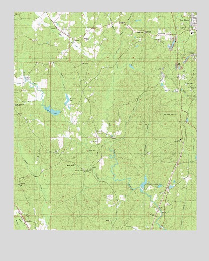
West Blocton West, AL USGS Topographic Map
Click on map above to begin viewing in our Map Viewer.

This topographic map contains these locations and features:
Feature Name Type Latitude Longitude GNIS ID View Map
Ada ChapelChurchN33.0715°W87.2489°151655View Map
BelchersPopulated PlaceN33.1096°W87.2089°156043View Map
Belchers CemeteryCemeteryN33.1096°W87.1989°113840View Map
Bibb County LakeReservoirN33.0273°W87.1609°149505View Map
Bibb County Vocational SchoolSchoolN33.0515°W87.1358°138355View Map
Bibb Lookout TowerTowerN33.0665°W87.1406°164286View Map
Blocton Third Baptist ChurchChurchN33.1010°W87.1264°151002View Map
Braehead (historical)Populated PlaceN33.0829°W87.1536°138359View Map
Braehead Slope MineMineN33.0685°W87.1722°138360View Map
Camps Forge (historical)LocaleN33.0298°W87.1689°138364View Map
Cedar Grove Fire DepartmentBuildingN33.0794°W87.2464°2683261View Map
Chase Lake DamDamN33.0668°W87.2183°131186View Map
Clifton BranchStreamN33.1107°W87.1781°116266View Map
Crystal LakeReservoirN33.0682°W87.2236°116940View Map
Daniel CemeteryCemeteryN33.1090°W87.1539°117045View Map
Fikestown (historical)Populated PlaceN33.0843°W87.1506°1959607View Map
Friday CemeteryCemeteryN33.0512°W87.1819°149507View Map
Galloway BranchStreamN33.0248°W87.1636°118795View Map
George Stewart CemeteryCemeteryN33.0718°W87.2494°151790View Map
Haysop CemeteryCemeteryN33.0273°W87.2453°151009View Map
Haysop Missionary Baptist ChurchChurchN33.0268°W87.2456°151804View Map
Hill CreekStreamN33.0296°W87.1822°158844View Map
Hill Creek MineMineN33.1237°W87.1258°138378View Map
Holland BranchStreamN33.1190°W87.1719°120233View Map
Hopewell Primitive Baptist ChurchChurchN33.1132°W87.1600°151816View Map
JohnstownPopulated PlaceN33.1154°W87.2197°1959614View Map
Johnstown Baptist ChurchChurchN33.1154°W87.2208°151907View Map
Johnstown CemeteryCemeteryN33.1146°W87.2178°151906View Map
Johnstown School (historical)SchoolN33.1143°W87.2194°138380View Map
Jones LakeReservoirN33.0939°W87.1697°138381View Map
Kinard CemeteryCemeteryN33.1137°W87.1605°121203View Map
Licklog BranchStreamN33.0615°W87.2106°121601View Map
Little CemeteryCemeteryN33.1193°W87.1778°121733View Map
Little CreekStreamN33.0860°W87.2422°121768View Map
Lone Star School (historical)SchoolN33.0312°W87.1317°138383View Map
LowerytownPopulated PlaceN33.1121°W87.1517°122088View Map
Lowerytown Baptist ChurchChurchN33.1121°W87.1519°154171View Map
LucillePopulated PlaceN33.0885°W87.1475°122101View Map
Lucille Baptist ChurchChurchN33.0879°W87.1483°154172View Map
McCulley CemeteryCemeteryN33.0809°W87.1267°122507View Map
McCulley CreekStreamN33.0993°W87.1822°122508View Map
McCulley CreekPopulated PlaceN33.0873°W87.1944°1959615View Map
McGrawtownPopulated PlaceN33.1221°W87.1281°1959616View Map
MoffatPopulated PlaceN33.0532°W87.1831°156724View Map
Moffat CemeteryCemeteryN33.0534°W87.1833°1959617View Map
Morris SpringSpringN33.0374°W87.2081°123089View Map
Mount Grove Baptist ChurchChurchN33.0957°W87.2033°123199View Map
Oldham CreekStreamN33.1004°W87.1894°124275View Map
Pearson Lake DamDamN33.0735°W87.2133°131188View Map
Pine Grove School (historical)SchoolN33.1001°W87.2167°138391View Map
Primitive RidgePopulated PlaceN33.1004°W87.1261°125281View Map
Red EaglePopulated PlaceN33.0846°W87.1322°156948View Map
Reed Arm BranchStreamN33.0718°W87.2311°125510View Map
Reedy BranchStreamN33.0040°W87.2278°1959621View Map
RichtownPopulated PlaceN33.1135°W87.1347°1959622View Map
Rockyview LakeReservoirN33.0724°W87.2136°153206View Map
ScottsvillePopulated PlaceN33.0332°W87.2000°138401View Map
Scottsville Baptist ChurchChurchN33.0348°W87.1994°153352View Map
Scottsville CemeteryCemeteryN33.0354°W87.2022°151007View Map
Scottsville CemeteryCemeteryN33.0443°W87.2211°151008View Map
Scottsville Cotton Mill (historical)LocaleN33.0357°W87.1961°1959624View Map
Scottsville Union ChurchChurchN33.0343°W87.2019°153353View Map
Shady Grove Dam Number OneDamN33.0251°W87.1683°131164View Map
Shady Grove Dam Number TwoDamN33.0235°W87.1550°131161View Map
Shady Grove Lake Number OneReservoirN33.0251°W87.1683°131163View Map
Shady Grove Lake Number TwoReservoirN33.0235°W87.1550°131162View Map
Shady Grove LakesReservoirN33.0273°W87.1609°126617View Map
Shallow FordCrossingN33.0607°W87.2106°1959625View Map
Siloam Baptist Church (historical)ChurchN33.0340°W87.2019°1959626View Map
Smiths FordCrossingN33.0462°W87.1989°157077View Map
Stewart CemeteryCemeteryN33.1134°W87.1614°127381View Map
Stone Quarry BranchStreamN33.0546°W87.1589°1959630View Map
Tiger StadiumParkN33.1136°W87.1275°2352005View Map
Town of West BloctonCivilN33.1186°W87.1253°2406861View Map
Tryon School (historical)SchoolN33.0440°W87.2203°138405View Map
Vernon CemeteryCemeteryN33.0512°W87.1928°128437View Map
VernontownPopulated PlaceN33.0565°W87.1939°157198View Map
Vernontown School (historical)SchoolN33.0621°W87.1953°138406View Map
West Blocton DivisionCivilN33.1244°W87.1413°165659View Map
West Blocton Elementary SchoolSchoolN33.1162°W87.1258°138408View Map
West Blocton High SchoolSchoolN33.1132°W87.1286°138409View Map
West Blocton Water WorksLocaleN33.0857°W87.2431°138410View Map
West Scottsville United Methodist ChurchChurchN33.0446°W87.2219°128797View Map
Williams CemeteryCemeteryN33.0871°W87.2417°129008View Map
Williams SpringSpringN33.0857°W87.2428°1959631View Map

Note: Coordinates in the location and feature list above are referenced to NAD83 datum.


Copyright (C) 2008-2025 Ryan Niemi / Sunset Dynamics ... All Rights Reserved