TopoQuest Logo
Do you find TopoQuest useful?
Help keep TopoQuest running and adding new maps/features by donating!
Bitcoin:  19c7KJd3qBynnjoSw5npx9KScwjBe4ifkT
Litecoin:  LXs6TkuXGGXo1vDsWCkWVdjQX94eUKd6ui
Home View Maps Find Maps Find Places Resources & Links


Ransom Stand, Tennessee Topographic Map

USGS Map Title: Ransom Stand, TN
USGS Map MRC: 35087A8
DRG (GeoTIFF) Download: o35087a8.tif


Neighboring USGS Topographic Map Quads:


  Wolf Pit Ridge, TN  
35088B1
 

  Martins Mills, TN  
35087B8
 

  Three Churches, TN  
35087B7
 

  Lowryville, TN  
35088A1
 

  Ransom Stand, TN  
35087A8
 

  Cypress Inn, TN  
35087A7
 

  Waterloo, AL  
34088H1
 

  Wright, AL  
34087H8
 

  Threet, AL  
34087H7


Map MRC Location:

N36°
W88°
N36°
W87°
H8 H7 H6 H5 H4 H3 H2 H1
G8 G7 G6 G5 G4 G3 G2 G1
F8 F7 F6 F5 F4 F3 F2 F1
E8 E7 E6 E5 E4 E3 E2 E1
D8 D7 D6 D5 D4 D3 D2 D1
C8 C7 C6 C5 C4 C3 C2 C1
B8 B7 B6 B5 B4 B3 B2 B1
A8 A7 A6 A5 A4 A3 A2 A1
N35°
W88°
N35°
W87°

Ransom Stand, TN USGS 1:24K Topographic Map Preview:
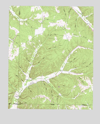
Ransom Stand, TN USGS Topographic Map
Click on map above to begin viewing in our Map Viewer.

This topographic map contains these locations and features:
Feature Name Type Latitude Longitude GNIS ID View Map
Adams HollowValleyN35.0561°W87.9679°1275469View Map
Brown CemeteryCemeteryN35.0773°W87.9209°1305439View Map
Brown HollowValleyN35.0773°W87.9500°1305451View Map
Burns BranchStreamN35.0834°W87.9953°1279082View Map
Carroll HollowValleyN35.0567°W87.9144°1279747View Map
Centenary CemeteryCemeteryN35.0298°W87.9659°1280113View Map
Daniels HollowValleyN35.1230°W87.9065°1282034View Map
Dodd School (historical)SchoolN35.0670°W87.9106°1302736View Map
Doolan HollowValleyN35.0887°W87.9404°1282643View Map
Florence HollowValleyN35.0099°W87.9893°1284501View Map
Gean CemeteryCemeteryN35.0992°W87.9217°1285265View Map
Grassy CreekStreamN35.0345°W87.9700°1285884View Map
Grassy Creek School (historical)SchoolN35.0837°W87.9595°1302750View Map
Grocery HollowValleyN35.0419°W87.8990°1286330View Map
Hand BranchStreamN35.0095°W87.9923°1286717View Map
Highway 69 Volunteer Fire DepartmentBuildingN35.0123°W87.9418°2653841View Map
Jeffery HollowValleyN35.0517°W87.9650°1289334View Map
Jeffery Hollow BranchStreamN35.0520°W87.9675°1646840View Map
Johnson HollowValleyN35.0270°W87.9724°1289606View Map
Johnson Mill BranchStreamN35.1109°W87.8895°1289645View Map
Johnson School (historical)SchoolN35.0343°W87.9528°1302764View Map
Johnson School (historical)SchoolN35.1167°W87.8917°1302765View Map
Jones HollowValleyN35.0173°W87.9247°1289795View Map
Lige HollowValleyN35.0460°W87.9096°1291260View Map
Lutts Lookout TowerTowerN35.0892°W87.9186°1647777View Map
McFalls CemeteryCemeteryN35.0376°W87.9359°1293278View Map
McFalls ChurchChurchN35.0970°W87.9161°1293279View Map
McFalls HollowValleyN35.0345°W87.9492°1293280View Map
McFalls RidgeRidgeN35.0890°W87.8931°1293281View Map
Mill HollowValleyN35.0254°W87.9297°1293864View Map
Murphy HollowValleyN35.0261°W87.9356°1295124View Map
Old Baptist CemeteryCemeteryN35.0109°W87.9872°1323889View Map
Patsy HollowValleyN35.0511°W87.8936°1296916View Map
Patterson HollowValleyN35.1139°W87.8961°1296961View Map
Piney Grove ChurchChurchN35.0043°W87.8884°163832View Map
Prospect Church (historical)ChurchN35.0193°W87.9909°1323914View Map
Ransom StandPopulated PlaceN35.0312°W87.9617°1315783View Map
Right Fork Second CreekStreamN35.0459°W87.9231°1299435View Map
Sage (historical)Populated PlaceN35.0742°W87.9125°1302794View Map
Second Creek ChurchChurchN35.0156°W87.9853°1301021View Map
Shelby HollowValleyN35.0424°W87.9745°1269987View Map
Stave Mill BranchStreamN35.1081°W87.9773°1271287View Map
StoutPopulated PlaceN35.0159°W87.9850°1302804View Map
Stout CemeteryCemeteryN35.0337°W87.9506°1271538View Map
Stribling CemeteryCemeteryN35.1242°W87.9067°1641911View Map
Tally BranchStreamN35.0370°W87.9459°1272066View Map
Wallace HollowValleyN35.0315°W87.9780°1273684View Map
Weatherford (historical)Populated PlaceN35.1129°W87.8870°1302820View Map
Weatherford-Bear Dam Number One BDamN35.0966°W87.8755°1301556View Map
White HollowValleyN35.0002°W87.9871°128875View Map

Note: Coordinates in the location and feature list above are referenced to NAD83 datum.


Copyright (C) 2008-2025 Ryan Niemi / Sunset Dynamics ... All Rights Reserved