TopoQuest Logo
Do you find TopoQuest useful?
Help keep TopoQuest running and adding new maps/features by donating!
Bitcoin:  19c7KJd3qBynnjoSw5npx9KScwjBe4ifkT
Litecoin:  LXs6TkuXGGXo1vDsWCkWVdjQX94eUKd6ui
Home View Maps Find Maps Find Places Resources & Links


Xenia, Illinois Topographic Map

USGS Map Title: Xenia, IL
USGS Map MRC: 38088F6
DRG (GeoTIFF) Download: o38088f6.tif


Neighboring USGS Topographic Map Quads:


  Kinmundy, IL  
38088G7
 

  Oskaloosa, IL  
38088G6
 

  Louisville West, IL  
38088G5
 

  Omega, IL  
38088F7
 

  Xenia, IL  
38088F6
 

  Xenia NE, IL  
38088F5
 

  Iuka, IL  
38088E7
 

  Orchardville, IL  
38088E6
 

  Johnsonville, IL  
38088E5


Map MRC Location:

N39°
W89°
N39°
W88°
H8 H7 H6 H5 H4 H3 H2 H1
G8 G7 G6 G5 G4 G3 G2 G1
F8 F7 F6 F5 F4 F3 F2 F1
E8 E7 E6 E5 E4 E3 E2 E1
D8 D7 D6 D5 D4 D3 D2 D1
C8 C7 C6 C5 C4 C3 C2 C1
B8 B7 B6 B5 B4 B3 B2 B1
A8 A7 A6 A5 A4 A3 A2 A1
N38°
W89°
N38°
W88°

Xenia, IL USGS 1:24K Topographic Map Preview:
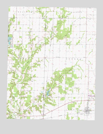
Xenia, IL USGS Topographic Map
Click on map above to begin viewing in our Map Viewer.

This topographic map contains these locations and features:
Feature Name Type Latitude Longitude GNIS ID View Map
Bethel (historical)Populated PlaceN38.7042°W88.6881°1747712View Map
Bobbies BranchStreamN38.7020°W88.7131°404638View Map
Brown ChurchChurchN38.7228°W88.7195°404946View Map
Brown School (historical)SchoolN38.7223°W88.7203°1737028View Map
Center School (historical)SchoolN38.6945°W88.6528°1747716View Map
Clack CemeteryCemeteryN38.6762°W88.7423°406138View Map
Conners BranchStreamN38.6314°W88.7326°406479View Map
Conners ChapelChurchN38.6945°W88.6770°406480View Map
Crabapple BranchStreamN38.6634°W88.7339°406705View Map
Dums CreekStreamN38.6256°W88.7409°407478View Map
Edwards Family CemeteryCemeteryN38.6784°W88.6812°1952666View Map
Forbes LakeReservoirN38.7148°W88.7456°408493View Map
Forbes Lake DamDamN38.7117°W88.7484°1691209View Map
Forest School (historical)SchoolN38.6642°W88.6767°1747726View Map
GreendalePopulated PlaceN38.6298°W88.6978°422755View Map
Greendale LakeReservoirN38.6552°W88.6915°409423View Map
Greendale Lake DamDamN38.6519°W88.6933°1691103View Map
Independent Order of Oddfellows CemeteryCemeteryN38.6314°W88.6412°1807697View Map
Jamison CreekStreamN38.6264°W88.7431°411035View Map
Lakeview Picnic AreaLocaleN38.7145°W88.7451°1821417View Map
Lone Star School (historical)SchoolN38.7456°W88.6817°1747734View Map
Lost ForkStreamN38.6831°W88.7337°412652View Map
Marlow PondReservoirN38.7034°W88.7467°1692201View Map
Marlow Pond DamDamN38.7034°W88.7467°1692200View Map
Mount Carmel Church (historical)ChurchN38.7231°W88.7434°1737076View Map
Onstott ChurchChurchN38.6450°W88.6551°415131View Map
Paine School (historical)SchoolN38.6400°W88.6764°1747745View Map
Parker CemeteryCemeteryN38.7084°W88.6970°415394View Map
Phillips CemeteryCemeteryN38.7373°W88.7442°415610View Map
Pickle CreekStreamN38.7231°W88.6856°415635View Map
Russell School (historical)SchoolN38.7239°W88.6473°1747749View Map
Salem CemeteryCemeteryN38.6439°W88.6548°1821638View Map
Shadden CemeteryCemeteryN38.6675°W88.7131°418250View Map
Shadden School (historical)SchoolN38.6681°W88.7167°1737096View Map
Smith CemeteryCemeteryN38.7256°W88.7159°418622View Map
Songer CemeteryCemeteryN38.6606°W88.6537°418704View Map
Stipp CemeteryCemeteryN38.7398°W88.6673°419148View Map
Sutton CreekStreamN38.7187°W88.6898°419440View Map
Toliver CemeteryCemeteryN38.6487°W88.6262°419763View Map
Township of SongerCivilN38.6945°W88.6405°429760View Map
Township of XeniaCivilN38.6286°W88.6413°429965View Map
Village of XeniaCivilN38.6371°W88.6374°2399748View Map
White Pine School (historical)SchoolN38.6928°W88.6862°1747762View Map
Woodland School (historical)SchoolN38.6278°W88.7209°1737114View Map
Woodlawn ChurchChurchN38.6278°W88.7245°421457View Map
XeniaPopulated PlaceN38.6359°W88.6348°421544View Map
Xenia Grade SchoolSchoolN38.6392°W88.6345°1807707View Map
Xenia Oil FieldOilfieldN38.6378°W88.6581°425654View Map
Xenia Post OfficePost OfficeN38.6354°W88.6376°2788758View Map
Xenia Volunteer Fire Protection DistrictBuildingN38.6361°W88.6357°2681720View Map
Zion Church (historical)ChurchN38.6828°W88.6348°1747764View Map

Note: Coordinates in the location and feature list above are referenced to NAD83 datum.


Copyright (C) 2008-2025 Ryan Niemi / Sunset Dynamics ... All Rights Reserved