TopoQuest Logo
Do you find TopoQuest useful?
Help keep TopoQuest running and adding new maps/features by donating!
Bitcoin:  19c7KJd3qBynnjoSw5npx9KScwjBe4ifkT
Litecoin:  LXs6TkuXGGXo1vDsWCkWVdjQX94eUKd6ui
Home View Maps Find Maps Find Places Resources & Links


Yellowstone Lake, Wisconsin Topographic Map

USGS Map Title: Yellowstone Lake, WI
USGS Map MRC: 42089G8
DRG (GeoTIFF) Download: o42089g8.tif


Neighboring USGS Topographic Map Quads:


  Jonesdale, WI  
42090H1
 

  Hollandale, WI  
42089H8
 

  Daleyville, WI  
42089H7
 

  Waldwick, WI  
42090G1
 

  Yellowstone Lake, WI  
42089G8
 

  Blanchardville, WI  
42089G7
 

  Darlington, WI  
42090F1
 

  Wiota, WI  
42089F8
 

  Argyle, WI  
42089F7


Map MRC Location:

N43°
W90°
N43°
W89°
H8 H7 H6 H5 H4 H3 H2 H1
G8 G7 G6 G5 G4 G3 G2 G1
F8 F7 F6 F5 F4 F3 F2 F1
E8 E7 E6 E5 E4 E3 E2 E1
D8 D7 D6 D5 D4 D3 D2 D1
C8 C7 C6 C5 C4 C3 C2 C1
B8 B7 B6 B5 B4 B3 B2 B1
A8 A7 A6 A5 A4 A3 A2 A1
N42°
W90°
N42°
W89°

Yellowstone Lake, WI USGS 1:24K Topographic Map Preview:
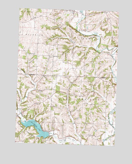
Yellowstone Lake, WI USGS Topographic Map
Click on map above to begin viewing in our Map Viewer.

This topographic map contains these locations and features:
Feature Name Type Latitude Longitude GNIS ID View Map
Calvary CemeteryCemeteryN42.8683°W89.9743°1562534View Map
Canon CreekStreamN42.7869°W89.9935°1562706View Map
Dodge BranchStreamN42.8739°W89.9207°1564020View Map
Durkin SchoolSchoolN42.8314°W89.9507°1564201View Map
Glenn ValleyValleyN42.8419°W89.9060°1565577View Map
Hidden Valley Lake 1ReservoirN42.7500°W89.9468°1793171View Map
Hidden Valley Lake G6316 DamDamN42.7500°W89.9468°1793170View Map
Hollandale Volunteer Fire DepartmentBuildingN42.8739°W89.9357°2697764View Map
Hollandale Wastewater Treatment FacilityLocaleN42.8747°W89.9261°2709375View Map
Horseshoe BendBendN42.8400°W89.8790°1566721View Map
McClintock CreekStreamN42.7503°W89.9157°1569180View Map
Moscow Center SchoolSchoolN42.8739°W89.8901°1569765View Map
Olson CreekStreamN42.8392°W89.9029°1577297View Map
Pecatonica Elementary SchoolSchoolN42.8715°W89.9325°1837773View Map
Prairie SchoolSchoolN42.8667°W89.9807°1571890View Map
Regan CreekStreamN42.8486°W89.9396°1577260View Map
Saint Michaels Catholic CemeteryCemeteryN42.7867°W89.9760°1989683View Map
Saint Michaels ChurchChurchN42.7867°W89.9754°1573380View Map
Schmidt CreekStreamN42.8417°W89.9273°1577378View Map
Steiner BranchStreamN42.7703°W89.9921°1574849View Map
Town of BlanchardCivilN42.7914°W89.8982°1582827View Map
Town of MoscowCivilN42.8645°W89.8965°1583755View Map
Woodlawn SchoolSchoolN42.8336°W89.9862°1577012View Map
YellowstonePopulated PlaceN42.7983°W89.9704°1577897View Map
Yellowstone 2WP88652 DamDamN42.7589°W89.9579°1791798View Map
Yellowstone ChurchChurchN42.7589°W89.9060°1577094View Map
Yellowstone Conservation AreaParkN42.7592°W89.9873°1577095View Map
Yellowstone LakeReservoirN42.7641°W89.9739°1577096View Map
Yellowstone Lake 18ReservoirN42.7567°W89.9568°1791799View Map
Yellowstone Lutheran CemeteryCemeteryN42.7592°W89.9060°1851615View Map
Yellowstone Savanna State Natural AreaParkN42.7728°W89.9612°1988943View Map

Note: Coordinates in the location and feature list above are referenced to NAD83 datum.


Copyright (C) 2008-2025 Ryan Niemi / Sunset Dynamics ... All Rights Reserved