TopoQuest Logo
Do you find TopoQuest useful?
Help keep TopoQuest running and adding new maps/features by donating!
Bitcoin:  19c7KJd3qBynnjoSw5npx9KScwjBe4ifkT
Litecoin:  LXs6TkuXGGXo1vDsWCkWVdjQX94eUKd6ui
Home View Maps Find Maps Find Places Resources & Links


Hollandale, Wisconsin Topographic Map

USGS Map Title: Hollandale, WI
USGS Map MRC: 42089H8
DRG (GeoTIFF) Download: o42089h8.tif


Neighboring USGS Topographic Map Quads:


  Pleasant Ridge, WI  
43090A1
 

  Barneveld, WI  
43089A8
 

  Blue Mounds, WI  
43089A7
 

  Jonesdale, WI  
42090H1
 

  Hollandale, WI  
42089H8
 

  Daleyville, WI  
42089H7
 

  Waldwick, WI  
42090G1
 

  Yellowstone Lake, WI  
42089G8
 

  Blanchardville, WI  
42089G7


Map MRC Location:

N43°
W90°
N43°
W89°
H8 H7 H6 H5 H4 H3 H2 H1
G8 G7 G6 G5 G4 G3 G2 G1
F8 F7 F6 F5 F4 F3 F2 F1
E8 E7 E6 E5 E4 E3 E2 E1
D8 D7 D6 D5 D4 D3 D2 D1
C8 C7 C6 C5 C4 C3 C2 C1
B8 B7 B6 B5 B4 B3 B2 B1
A8 A7 A6 A5 A4 A3 A2 A1
N42°
W90°
N42°
W89°

Hollandale, WI USGS 1:24K Topographic Map Preview:
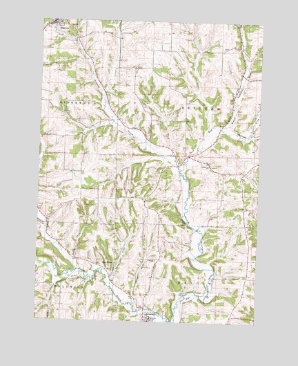
Hollandale, WI USGS Topographic Map
Click on map above to begin viewing in our Map Viewer.

This topographic map contains these locations and features:
Feature Name Type Latitude Longitude GNIS ID View Map
0.5 ReservoirReservoirN42.9300°W89.9318°1793325View Map
1 ReservoirReservoirN42.8950°W89.9451°1793341View Map
Adamsville (historical)Populated PlaceN42.9072°W89.9126°2760537View Map
Banner ValleyValleyN42.9013°W89.9793°1561151View Map
Conley Lewis CreekStreamN42.8961°W89.9776°1577295View Map
Desmet Airport (historical)AirportN42.9453°W89.8990°1581875View Map
HollandalePopulated PlaceN42.8758°W89.9362°1566549View Map
Jones ValleyValleyN42.9395°W89.9191°1567279View Map
Long ValleyValleyN42.8859°W89.9452°1568599View Map
Long Valley CemeteryCemeteryN42.9008°W89.9329°1568600View Map
Long Valley CreekStreamN42.8825°W89.9454°1848424View Map
MiddleburyPopulated PlaceN42.9373°W89.8830°2760538View Map
Middlebury ChurchChurchN42.9397°W89.9029°1569439View Map
Nelson G 7414 DamDamN42.9300°W89.9318°1793324View Map
Ridgeway Elementary SchoolSchoolN42.9986°W89.9898°1837776View Map
Ryan SpringSpringN42.8989°W89.9626°1572771View Map
Smith Conley CreekStreamN42.9397°W89.9204°1572306View Map
Spring ValleyValleyN42.8921°W89.9577°1574698View Map
Star ValleyValleyN42.8754°W89.9204°1574812View Map
Town of BrighamCivilN42.9946°W89.8972°1582857View Map
Town of RidgewayCivilN42.9532°W89.9955°1584035View Map
Urnus CreekStreamN42.8892°W89.9579°1577296View Map
Village of HollandaleCivilN42.8756°W89.9342°1583403View Map
Village of RidgewayCivilN42.9985°W89.9932°1584034View Map
Warzyn G-8862 DamDamN42.8950°W89.9451°1793340View Map
Whitford CreekStreamN42.8939°W89.9826°1577251View Map
Williams-Barneveld CreekStreamN42.9567°W89.8957°1576765View Map

Note: Coordinates in the location and feature list above are referenced to NAD83 datum.


Copyright (C) 2008-2025 Ryan Niemi / Sunset Dynamics ... All Rights Reserved