TopoQuest Logo
Do you find TopoQuest useful?
Help keep TopoQuest running and adding new maps/features by donating!
Bitcoin:  19c7KJd3qBynnjoSw5npx9KScwjBe4ifkT
Litecoin:  LXs6TkuXGGXo1vDsWCkWVdjQX94eUKd6ui
Home View Maps Find Maps Find Places Resources & Links


Zanesville, Indiana Topographic Map

USGS Map Title: Zanesville, IN
USGS Map MRC: 40085H3
DRG (GeoTIFF) Download: o40085h3.tif


Neighboring USGS Topographic Map Quads:


  Laud, IN  
41085A4
 

  Arcola, IN  
41085A3
 

  Fort Wayne West, IN  
41085A2
 

  Huntington, IN  
40085H4
 

  Zanesville, IN  
40085H3
 

  Ossian, IN  
40085H2
 

  Majenica, IN  
40085G4
 

  Markle, IN  
40085G3
 

  Uniondale, IN  
40085G2


Map MRC Location:

N41°
W86°
N41°
W85°
H8 H7 H6 H5 H4 H3 H2 H1
G8 G7 G6 G5 G4 G3 G2 G1
F8 F7 F6 F5 F4 F3 F2 F1
E8 E7 E6 E5 E4 E3 E2 E1
D8 D7 D6 D5 D4 D3 D2 D1
C8 C7 C6 C5 C4 C3 C2 C1
B8 B7 B6 B5 B4 B3 B2 B1
A8 A7 A6 A5 A4 A3 A2 A1
N40°
W86°
N40°
W85°

Zanesville, IN USGS 1:24K Topographic Map Preview:
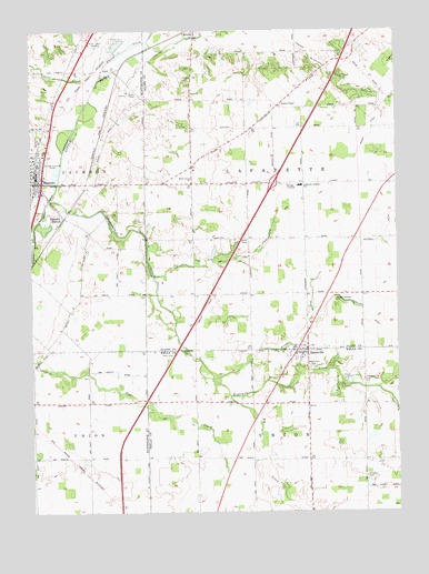
Zanesville, IN USGS Topographic Map
Click on map above to begin viewing in our Map Viewer.

This topographic map contains these locations and features:
Feature Name Type Latitude Longitude GNIS ID View Map
Aboite CreekStreamN40.9878°W85.3516°429992View Map
Beech Grove ChurchChurchN40.9620°W85.3200°430731View Map
Big CreekStreamN40.9050°W85.3072°431029View Map
Calf CreekStreamN40.9862°W85.3528°431958View Map
Cow CreekStreamN40.9606°W85.3655°433053View Map
Eightmile CreekStreamN40.9562°W85.3686°434050View Map
Fisher Farm Airport (historical)AirportN40.9459°W85.3700°449325View Map
Graham McCulloch Ditch Number FourCanalN40.9898°W85.2744°435288View Map
Hoverstock CemeteryCemeteryN40.9135°W85.2812°436530View Map
Lafayette Central SchoolSchoolN40.9598°W85.2833°437502View Map
Mason DitchCanalN40.9720°W85.2600°438694View Map
McPherren DitchCanalN40.9645°W85.3744°438931View Map
Monson ChapelChurchN40.9814°W85.2889°439350View Map
Parkview Hospital Emergency Medical ServicesBuildingN40.9617°W85.3729°2719311View Map
Pleasant Run DitchCanalN40.9420°W85.2994°441315View Map
RoanokePopulated PlaceN40.9625°W85.3733°442129View Map
Roanoke Police DepartmentBuildingN40.9617°W85.3731°2758226View Map
Roanoke StationPopulated PlaceN40.9520°W85.3641°442130View Map
Roanoke Volunteer Fire DepartmentBuildingN40.9616°W85.3728°2625582View Map
Saint Johns CemeteryCemeteryN40.8840°W85.2609°442576View Map
Temple Timbers ChurchChurchN40.9300°W85.2708°444629View Map
Town of ZanesvilleCivilN40.9154°W85.2807°2397760View Map
Township of LafayetteCivilN40.9599°W85.2797°453530View Map
Uniontown ChurchChurchN40.9089°W85.2608°445139View Map
Witzgall DitchCanalN40.9309°W85.2786°446227View Map
WOWD-AM (Fort Wayne)TowerN40.9964°W85.3516°448423View Map
ZanesvillePopulated PlaceN40.9173°W85.2805°446424View Map

Note: Coordinates in the location and feature list above are referenced to NAD83 datum.


Copyright (C) 2008-2025 Ryan Niemi / Sunset Dynamics ... All Rights Reserved