TopoQuest Logo
Do you find TopoQuest useful?
Help keep TopoQuest running and adding new maps/features by donating!
Bitcoin:  19c7KJd3qBynnjoSw5npx9KScwjBe4ifkT
Litecoin:  LXs6TkuXGGXo1vDsWCkWVdjQX94eUKd6ui
Home View Maps Find Maps Find Places Resources & Links


Bowman, South Carolina Topographic Map

USGS Map Title: Bowman, SC
USGS Map MRC: 33080C6
DRG (GeoTIFF) Download: o33080c6.tif


Neighboring USGS Topographic Map Quads:


  Orangeburg South, SC  
33080D7
 

  Indian Camp Branch, SC  
33080D6
 

  Felderville, SC  
33080D5
 

  Branchville North, SC  
33080C7
 

  Bowman, SC  
33080C6
 

  Wadboo Swamp, SC  
33080C5
 

  Branchville South, SC  
33080B7
 

  Reevesville, SC  
33080B6
 

  Saint George, SC  
33080B5


Map MRC Location:

N34°
W81°
N34°
W80°
H8 H7 H6 H5 H4 H3 H2 H1
G8 G7 G6 G5 G4 G3 G2 G1
F8 F7 F6 F5 F4 F3 F2 F1
E8 E7 E6 E5 E4 E3 E2 E1
D8 D7 D6 D5 D4 D3 D2 D1
C8 C7 C6 C5 C4 C3 C2 C1
B8 B7 B6 B5 B4 B3 B2 B1
A8 A7 A6 A5 A4 A3 A2 A1
N33°
W81°
N33°
W80°

Bowman, SC USGS 1:24K Topographic Map Preview:
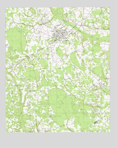
Bowman, SC USGS Topographic Map
Click on map above to begin viewing in our Map Viewer.

This topographic map contains these locations and features:
Feature Name Type Latitude Longitude GNIS ID View Map
Antioch ChurchChurchN33.3421°W80.6759°1242509View Map
BowmanPopulated PlaceN33.3488°W80.6829°1246954View Map
Bowman DivisionCivilN33.3405°W80.6580°1938208View Map
Bowman Elementary SchoolSchoolN33.3510°W80.6881°1242526View Map
Bowman Fire DepartmentBuildingN33.3539°W80.6824°2368188View Map
Bowman Fire Department AdministrationBuildingN33.3530°W80.6872°2368366View Map
Bowman High SchoolSchoolN33.3421°W80.6904°1242527View Map
Bowman Police DepartmentBuildingN33.3495°W80.6830°2334884View Map
Bowman Post OfficePost OfficeN33.3493°W80.6835°1252271View Map
Bowman Southern Methodist ChurchChurchN33.3515°W80.6851°2489993View Map
Buck BranchStreamN33.3679°W80.7498°1250762View Map
Buck BranchStreamN33.3657°W80.6901°1221063View Map
Cattle Creek Fire DepartmentBuildingN33.2857°W80.7192°2368479View Map
Cattle Creek Fire Department Station 2BuildingN33.2636°W80.7124°2578849View Map
Frederick SchoolSchoolN33.3693°W80.7381°1222546View Map
Hickory Hill School (historical)SchoolN33.2579°W80.6720°1245971View Map
Johnson SchoolSchoolN33.3557°W80.7251°1223615View Map
LambrickPopulated PlaceN33.3063°W80.7345°1231463View Map
Mount Olive ChurchChurchN33.3165°W80.7270°1242713View Map
Mount Olive School (historical)SchoolN33.3163°W80.7265°1249632View Map
Mount Tabor Baptist ChurchChurchN33.2663°W80.6965°1249680View Map
Mount Tabor CemeteryCemeteryN33.2671°W80.6973°1242719View Map
Murray Branch SchoolSchoolN33.2585°W80.7201°1224894View Map
Murray SchoolSchoolN33.3007°W80.6304°1249765View Map
Polk SwampSwampN33.2833°W80.6856°1225585View Map
Prospect ChurchChurchN33.2588°W80.6976°1225689View Map
Rigby CemeteryCemeteryN33.2571°W80.6790°1242799View Map
Sandy RunPopulated PlaceN33.3229°W80.7156°1226377View Map
Sandy RunStreamN33.2768°W80.7287°1226381View Map
Sandy Run SchoolSchoolN33.2940°W80.7195°1226390View Map
Snell Branch School (historical)SchoolN33.2827°W80.6532°1242853View Map
Town of BowmanCivilN33.3482°W80.6844°2405307View Map
West School (historical)SchoolN33.2554°W80.7462°1242891View Map

Note: Coordinates in the location and feature list above are referenced to NAD83 datum.


Copyright (C) 2008-2025 Ryan Niemi / Sunset Dynamics ... All Rights Reserved