TopoQuest Logo
Do you find TopoQuest useful?
Help keep TopoQuest running and adding new maps/features by donating!
Bitcoin:  19c7KJd3qBynnjoSw5npx9KScwjBe4ifkT
Litecoin:  LXs6TkuXGGXo1vDsWCkWVdjQX94eUKd6ui
Home View Maps Find Maps Find Places Resources & Links


Reevesville, South Carolina Topographic Map

USGS Map Title: Reevesville, SC
USGS Map MRC: 33080B6
DRG (GeoTIFF) Download: o33080b6.tif


Neighboring USGS Topographic Map Quads:


  Branchville North, SC  
33080C7
 

  Bowman, SC  
33080C6
 

  Wadboo Swamp, SC  
33080C5
 

  Branchville South, SC  
33080B7
 

  Reevesville, SC  
33080B6
 

  Saint George, SC  
33080B5
 

  Williams, SC  
33080A7
 

  Saint George SW, SC  
33080A6
 

  Canadys, SC  
33080A5


Map MRC Location:

N34°
W81°
N34°
W80°
H8 H7 H6 H5 H4 H3 H2 H1
G8 G7 G6 G5 G4 G3 G2 G1
F8 F7 F6 F5 F4 F3 F2 F1
E8 E7 E6 E5 E4 E3 E2 E1
D8 D7 D6 D5 D4 D3 D2 D1
C8 C7 C6 C5 C4 C3 C2 C1
B8 B7 B6 B5 B4 B3 B2 B1
A8 A7 A6 A5 A4 A3 A2 A1
N33°
W81°
N33°
W80°

Reevesville, SC USGS 1:24K Topographic Map Preview:
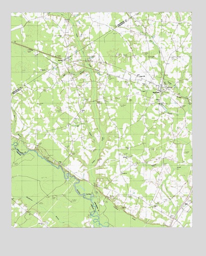
Reevesville, SC USGS Topographic Map
Click on map above to begin viewing in our Map Viewer.

This topographic map contains these locations and features:
Feature Name Type Latitude Longitude GNIS ID View Map
Appleby CemeteryCemeteryN33.1371°W80.6515°1248775View Map
Appleby ChurchChurchN33.1377°W80.6512°1245674View Map
Bear BranchStreamN33.1938°W80.6279°1220392View Map
Bethel CemeteryCemeteryN33.2077°W80.6570°1241046View Map
Bethel ChurchChurchN33.2129°W80.6626°1241048View Map
Beulah CemeteryCemeteryN33.1604°W80.7129°1248776View Map
Beulah ChurchChurchN33.1627°W80.7148°1220635View Map
Big BranchStreamN33.1713°W80.6882°1241049View Map
Box BranchStreamN33.1710°W80.7382°1220913View Map
Cat HolePopulated PlaceN33.1446°W80.6940°1241065View Map
Cattle CreekStreamN33.1424°W80.6951°1221411View Map
Cattle Creek (historical)Populated PlaceN33.2057°W80.7220°1241062View Map
Cattle Creek Fire Department Station 1BuildingN33.2215°W80.7072°2368180View Map
Cattle Creek SchoolSchoolN33.1813°W80.7268°1221412View Map
Connor CemeteryCemeteryN33.1282°W80.7479°1240601View Map
DorangePopulated PlaceN33.2227°W80.7068°1247539View Map
Dorange School (historical)SchoolN33.2224°W80.7109°1241078View Map
Edisto SchoolSchoolN33.1349°W80.7398°1222240View Map
Greenville ChurchChurchN33.1571°W80.6737°1241113View Map
Greenville SchoolSchoolN33.1571°W80.6743°1222895View Map
Hagerman CemeteryCemeteryN33.1368°W80.6737°1241116View Map
Harver ChapelChurchN33.1407°W80.6251°1250686View Map
Heaton CemeteryCemeteryN33.1715°W80.6681°1241119View Map
Huggins Oak School (historical)SchoolN33.1821°W80.7248°1241123View Map
Independence SchoolSchoolN33.1988°W80.6843°1223427View Map
Independent School (historical)SchoolN33.1849°W80.6668°1241127View Map
Jericho ChurchChurchN33.1932°W80.7020°1246162View Map
Joint School (historical)SchoolN33.2229°W80.7126°1242672View Map
Kelley SchoolSchoolN33.2357°W80.6576°1223704View Map
Magnolia CemeteryCemeteryN33.1982°W80.6479°1241140View Map
Mill BranchStreamN33.2160°W80.6943°1241145View Map
Mount Pisgah ChurchChurchN33.2168°W80.7257°1242717View Map
Murray BranchStreamN33.2482°W80.7115°1224893View Map
Oak Villa Church (historical)ChurchN33.1538°W80.6276°1241158View Map
Oak Villa SchoolSchoolN33.1554°W80.6287°1225134View Map
Old Miss CemeteryCemeteryN33.1282°W80.7273°1240695View Map
Patrick CemeteryCemeteryN33.1390°W80.7445°1240698View Map
ReevesvillePopulated PlaceN33.2057°W80.6479°1250333View Map
Reevesville Baptist ChurchChurchN33.2074°W80.6454°1241178View Map
Reevesville DivisionCivilN33.1458°W80.6419°1938395View Map
Reevesville Fire DepartmentBuildingN33.2076°W80.6481°2368151View Map
Saint Matthews ChurchChurchN33.2063°W80.6429°1241201View Map
Saint Peters School (historical)SchoolN33.1379°W80.6284°1241204View Map
School Number 82SchoolN33.2132°W80.7182°1226443View Map
Sugar HillPopulated PlaceN33.2127°W80.6609°1241225View Map
Thompson CemeteryCemeteryN33.2360°W80.7140°1242873View Map
Town of ReevesvilleCivilN33.2021°W80.6456°2407193View Map
Whitestone CemeteryCemeteryN33.1665°W80.6693°1241274View Map
Whitestone ChurchChurchN33.1660°W80.6698°1227575View Map

Note: Coordinates in the location and feature list above are referenced to NAD83 datum.


Copyright (C) 2008-2025 Ryan Niemi / Sunset Dynamics ... All Rights Reserved