TopoQuest Logo
Do you find TopoQuest useful?
Help keep TopoQuest running and adding new maps/features by donating!
Bitcoin:  19c7KJd3qBynnjoSw5npx9KScwjBe4ifkT
Litecoin:  LXs6TkuXGGXo1vDsWCkWVdjQX94eUKd6ui
Home View Maps Find Maps Find Places Resources & Links


Chesson, Alabama Topographic Map

USGS Map Title: Chesson, AL
USGS Map MRC: 32085C8
DRG (GeoTIFF) Download: o32085c8.tif


Neighboring USGS Topographic Map Quads:


  Brassell, AL  
32086D1
 

  Shorter, AL  
32085D8
 

  La Place, AL  
32085D7
 

  Mount Meigs, AL  
32086C1
 

  Chesson, AL  
32085C8
 

  Hardaway, AL  
32085C7
 

  Teasleys Mill, AL  
32086B1
 

  Fitzpatrick, AL  
32085B8
 

  Thompson, AL  
32085B7


Map MRC Location:

N33°
W86°
N33°
W85°
H8 H7 H6 H5 H4 H3 H2 H1
G8 G7 G6 G5 G4 G3 G2 G1
F8 F7 F6 F5 F4 F3 F2 F1
E8 E7 E6 E5 E4 E3 E2 E1
D8 D7 D6 D5 D4 D3 D2 D1
C8 C7 C6 C5 C4 C3 C2 C1
B8 B7 B6 B5 B4 B3 B2 B1
A8 A7 A6 A5 A4 A3 A2 A1
N32°
W86°
N32°
W85°

Chesson, AL USGS 1:24K Topographic Map Preview:
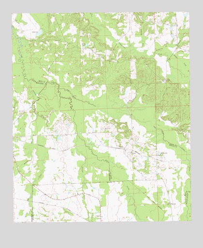
Chesson, AL USGS Topographic Map
Click on map above to begin viewing in our Map Viewer.

This topographic map contains these locations and features:
Feature Name Type Latitude Longitude GNIS ID View Map
Allens ChapelChurchN32.2604°W85.8897°113016View Map
Baca DamDamN32.3001°W85.9750°130390View Map
Baca LakeReservoirN32.3001°W85.9750°130389View Map
Bughall CreekStreamN32.2915°W85.8777°115166View Map
ChessonPopulated PlaceN32.2938°W85.9244°116013View Map
Cross KeysPopulated PlaceN32.3338°W85.8933°156232View Map
Halls PondLakeN32.3633°W85.9804°119603View Map
Jack Lacey Number 2 DamDamN32.3735°W85.8783°130497View Map
Johnsons CreekStreamN32.3349°W85.9886°120965View Map
Lacey Lake Number 2ReservoirN32.3733°W85.8771°130496View Map
Mathews SloughStreamN32.3146°W85.9827°122379View Map
Mathis ChapelChurchN32.3168°W85.9916°122383View Map
McDowell CreekStreamN32.2501°W85.9919°122529View Map
Mount Eland ChurchChurchN32.2538°W85.9391°152413View Map
Mount Olive CemeteryCemeteryN32.3462°W85.9300°154818View Map
Mount Olive ChurchChurchN32.3463°W85.9297°123300View Map
Mount Silah ChurchChurchN32.2907°W85.9161°123384View Map
Mount Zion CemeteryCemeteryN32.3057°W85.9352°123421View Map
Mount Zion ChurchChurchN32.3038°W85.9408°123461View Map
Old Millpond BranchStreamN32.3515°W85.9169°124228View Map
Old Town CreekStreamN32.3301°W85.9677°152798View Map
Oswalt CemeteryCemeteryN32.3032°W85.9333°141867View Map
Panther CreekStreamN32.3021°W85.9544°155185View Map
Pilgrim ChurchChurchN32.2896°W86.0000°152895View Map
Pilgrim ChurchChurchN32.2893°W86.0000°124727View Map
Saint Lukes Church (historical)ChurchN32.2790°W85.9944°142841View Map
Saint Marys Church (historical)ChurchN32.2768°W85.8963°135273View Map
Shorter-Hardaway DivisionCivilN32.3487°W85.9038°165861View Map
Silah CemeteryCemeteryN32.2912°W85.9161°154819View Map
Sleepy CreekStreamN32.3499°W85.8925°126967View Map
Spains LakeReservoirN32.2904°W85.8971°127159View Map
Thobolocco BranchStreamN32.3504°W85.8991°127855View Map
Weiss LakeReservoirN32.3558°W85.9474°128713View Map
White CemeteryCemeteryN32.3582°W85.9655°128865View Map
White ChurchChurchN32.3568°W85.9600°128867View Map

Note: Coordinates in the location and feature list above are referenced to NAD83 datum.


Copyright (C) 2008-2025 Ryan Niemi / Sunset Dynamics ... All Rights Reserved