TopoQuest Logo
Do you find TopoQuest useful?
Help keep TopoQuest running and adding new maps/features by donating!
Bitcoin:  19c7KJd3qBynnjoSw5npx9KScwjBe4ifkT
Litecoin:  LXs6TkuXGGXo1vDsWCkWVdjQX94eUKd6ui
Home View Maps Find Maps Find Places Resources & Links


Brigham City, Utah Topographic Map

USGS Map Title: Brigham City, UT
USGS Map MRC: 41112E1
DRG (GeoTIFF) Download: o41112e1.tif


Neighboring USGS Topographic Map Quads:


  Tremonton, UT  
41112F2
 

  Honeyville, UT  
41112F1
 

  Wellsville, UT  
41111F8


  Brigham City, UT  
41112E1
 

  Mount Pisgah, UT  
41111E8
 

  Whistler Canal, UT  
41112D2
 

  Willard, UT  
41112D1
 

  Mantua, UT  
41111D8


Map MRC Location:

N42°
W113°
N42°
W112°
H8 H7 H6 H5 H4 H3 H2 H1
G8 G7 G6 G5 G4 G3 G2 G1
F8 F7 F6 F5 F4 F3 F2 F1
E8 E7 E6 E5 E4 E3 E2 E1
D8 D7 D6 D5 D4 D3 D2 D1
C8 C7 C6 C5 C4 C3 C2 C1
B8 B7 B6 B5 B4 B3 B2 B1
A8 A7 A6 A5 A4 A3 A2 A1
N41°
W113°
N41°
W112°

Brigham City, UT USGS 1:24K Topographic Map Preview:
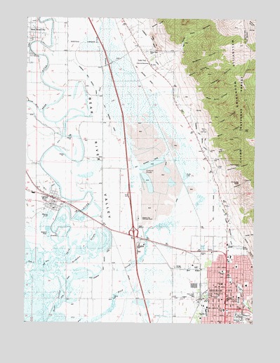
Brigham City, UT USGS Topographic Map
Click on map above to begin viewing in our Map Viewer.

This topographic map contains these locations and features:
Feature Name Type Latitude Longitude GNIS ID View Map
Antimony CanyonValleyN41.5633°W112.0180°1438252View Map
Asemblea de DiosChurchN41.5044°W112.0133°1449219View Map
Baker CanyonValleyN41.5752°W112.0238°1438330View Map
Baker MineMineN41.5788°W112.0063°1438337View Map
Bear River City CemeteryCemeteryN41.6096°W112.1230°1448117View Map
Box Elder CanalCanalN41.5135°W112.0086°1439066View Map
Box Elder County Sheriff's OfficeBuildingN41.5091°W112.0355°2730405View Map
Box Elder CreekStreamN41.5280°W112.0597°1439070View Map
Box Elder Middle SchoolSchoolN41.5097°W112.0087°1439072View Map
Brigham CityPopulated PlaceN41.5102°W112.0155°1439109View Map
Brigham City AirportAirportN41.5524°W112.0623°1455922View Map
Brigham City CemeteryCemeteryN41.5044°W112.0108°1448182View Map
Brigham City Country ClubLocaleN41.5294°W112.0199°1454399View Map
Brigham City Fire DepartmentBuildingN41.5112°W112.0232°2627109View Map
Brigham City Police DepartmentBuildingN41.5110°W112.0154°2730346View Map
Brigham City Post OfficePost OfficeN41.5100°W112.0177°2769045View Map
Brigham Young ParkParkN41.5108°W112.0194°1439111View Map
Bunderson SchoolSchoolN41.5160°W112.0047°1448208View Map
Call's Fort CemeteryCemeteryN41.6112°W112.0596°1441608View Map
Calls Fort (historical)MilitaryN41.6083°W112.0583°1451114View Map
Calls Fort CanyonValleyN41.6119°W112.0422°1439437View Map
Calls Fort MonumentParkN41.6060°W112.0588°1448219View Map
Cataract CanyonValleyN41.5949°W112.0324°1439535View Map
Cement PondsReservoirN41.5653°W112.0562°1439602View Map
Central SchoolSchoolN41.5052°W112.0166°1439632View Map
Chimney RockPillarN41.5577°W112.0091°1439687View Map
Church of ChristChurchN41.5058°W112.0249°1449238View Map
City of Bear River CityCivilN41.6124°W112.1250°2409803View Map
City of Brigham CityCivilN41.5034°W112.0454°2409910View Map
City of CorinneCivilN41.5497°W112.1228°2410228View Map
Community Presbyterian ChurchChurchN41.5044°W112.0133°1448298View Map
Cooley WellWellN41.5138°W112.0033°1439930View Map
Copper Blossom MineMineN41.5647°W112.0083°1439944View Map
CorinnePopulated PlaceN41.5510°W112.1102°1439951View Map
Corinne Early Learning CenterSchoolN41.5466°W112.1105°1448300View Map
Corinne Fire DepartmentBuildingN41.5487°W112.1107°2627330View Map
Corinne Post OfficePost OfficeN41.5502°W112.1112°2769050View Map
Dead RiverLakeN41.5226°W112.1146°1440306View Map
Donation CanyonValleyN41.6047°W112.0391°1440522View Map
Dry CanyonValleyN41.5691°W112.0216°1440579View Map
First Baptist ChurchChurchN41.5005°W112.0258°1448398View Map
Foothill Elementary SchoolSchoolN41.5274°W112.0134°1455077View Map
Hansen CanyonValleyN41.5449°W112.0163°1438086View Map
Holy Cross Lutheran ChurchChurchN41.5105°W112.0055°1449278View Map
Horseshoe SloughsLakeN41.5307°W112.0926°1441915View Map
KBUH-AM (Brigham City)TowerN41.5116°W112.0327°1455766View Map
KBUH-FM (Brigham City)TowerN41.5116°W112.0327°1455817View Map
Kotter CanyonValleyN41.5349°W112.0058°1442364View Map
Lincoln SchoolSchoolN41.5163°W112.0174°1442626View Map
Malad RiverStreamN41.5860°W112.1174°1443103View Map
Mallard PondLakeN41.5371°W112.1134°1443109View Map
Mill RunStreamN41.5566°W112.1083°1443474View Map
Miners HollowValleyN41.6013°W112.0366°1443515View Map
Mitton PeakSummitN41.6144°W112.0097°1451301View Map
Moss Rock CanyonValleyN41.5919°W112.0316°1443616View Map
North LakeReservoirN41.5583°W112.0424°1443954View Map
North PondReservoirN41.5115°W112.0258°1443970View Map
North String Irrigation DitchCanalN41.5472°W112.0172°1443980View Map
Precipice CanyonValleyN41.6188°W112.0563°1444633View Map
Rees ParkParkN41.5127°W112.0269°1455902View Map
Rees SpringSpringN41.5308°W112.0066°1444855View Map
Salt CreekStreamN41.5847°W112.0938°1445278View Map
Skating PondLakeN41.5428°W112.1119°1445631View Map
South PondLakeN41.5097°W112.0261°1445916View Map
The Church of Jesus Christ of Latter Day SaintsChurchN41.5005°W112.0133°1449380View Map
The Church of Jesus Christ of Latter Day SaintsChurchN41.5138°W112.0194°1449381View Map
The Church of Jesus Christ of Latter Day SaintsChurchN41.5030°W112.0286°1449382View Map
The Church of Jesus Christ of Latter Day SaintsChurchN41.5077°W112.0116°1449383View Map
The Church of Jesus Christ of Latter Day SaintsChurchN41.5110°W112.0119°1449384View Map
The Church of Jesus Christ of Latter Day SaintsChurchN41.5172°W112.0133°1449385View Map
The Church of Jesus Christ of Latter Day SaintsChurchN41.5005°W112.0258°1449386View Map
The Church of Jesus Christ of Latter Day SaintsChurchN41.5213°W112.0177°1449387View Map
The Church of Jesus Christ of Latter Day SaintsChurchN41.5238°W112.0119°1449388View Map
The Church of Jesus Christ of Latter Day SaintsChurchN41.5427°W112.1097°1449422View Map
The Church of Jesus Christ of Latter Day SaintsChurchN41.5233°W112.0202°1449470View Map
The HorseshoeLakeN41.5334°W112.1054°1446462View Map
Utah Highway Patrol Section 1 Brigham City OfficeBuildingN41.5250°W112.0164°2730468View Map
Yates CanyonValleyN41.5813°W112.0258°1447548View Map

Note: Coordinates in the location and feature list above are referenced to NAD83 datum.


Copyright (C) 2008-2025 Ryan Niemi / Sunset Dynamics ... All Rights Reserved