TopoQuest Logo
Do you find TopoQuest useful?
Help keep TopoQuest running and adding new maps/features by donating!
Bitcoin:  19c7KJd3qBynnjoSw5npx9KScwjBe4ifkT
Litecoin:  LXs6TkuXGGXo1vDsWCkWVdjQX94eUKd6ui
Home View Maps Find Maps Find Places Resources & Links


Wellsville, Utah Topographic Map

USGS Map Title: Wellsville, UT
USGS Map MRC: 41111F8
DRG (GeoTIFF) Download: o41111f8.tif


Neighboring USGS Topographic Map Quads:


  Cutler Dam, UT  
41112G1
 

  Newton, UT  
41111G8
 

  Smithfield, UT  
41111G7
 

  Honeyville, UT  
41112F1
 

  Wellsville, UT  
41111F8
 

  Logan, UT  
41111F7
 

  Brigham City, UT  
41112E1
 

  Mount Pisgah, UT  
41111E8
 

  Paradise, UT  
41111E7


Map MRC Location:

N42°
W112°
N42°
W111°
H8 H7 H6 H5 H4 H3 H2 H1
G8 G7 G6 G5 G4 G3 G2 G1
F8 F7 F6 F5 F4 F3 F2 F1
E8 E7 E6 E5 E4 E3 E2 E1
D8 D7 D6 D5 D4 D3 D2 D1
C8 C7 C6 C5 C4 C3 C2 C1
B8 B7 B6 B5 B4 B3 B2 B1
A8 A7 A6 A5 A4 A3 A2 A1
N41°
W112°
N41°
W111°

Wellsville, UT USGS 1:24K Topographic Map Preview:
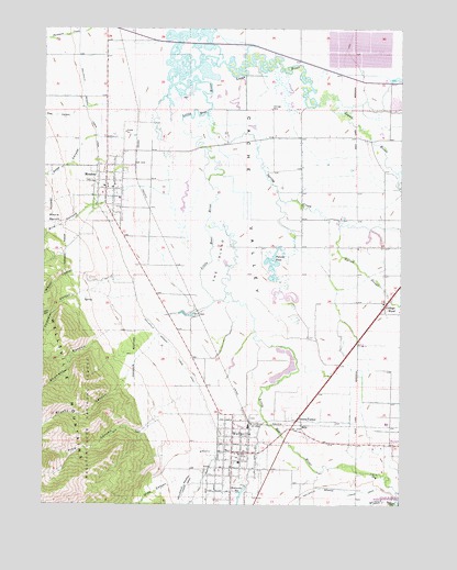
Wellsville, UT USGS Topographic Map
Click on map above to begin viewing in our Map Viewer.

This topographic map contains these locations and features:
Feature Name Type Latitude Longitude GNIS ID View Map
Benson Census Designated PlaceCensusN41.7489°W111.9169°2407829View Map
Bird CanyonValleyN41.7022°W111.9874°1438816View Map
Brushy CanyonValleyN41.6555°W111.9744°1426033View Map
City of MendonCivilN41.7101°W111.9778°2411077View Map
Coldwater CanyonValleyN41.6810°W111.9847°1439886View Map
College WardPopulated PlaceN41.6769°W111.8799°1439893View Map
Deep CanyonValleyN41.7194°W111.9877°1440343View Map
Gibson CanyonValleyN41.6858°W111.9886°1441312View Map
Greens CornerPopulated PlaceN41.6469°W111.9116°1441485View Map
Hell CanyonValleyN41.6752°W111.9980°1441673View Map
HillsLocaleN41.6458°W111.9097°1441776View Map
Hyrum SloughStreamN41.6985°W111.8961°1441973View Map
KVNU-AM (Logan)TowerN41.6749°W111.9358°1455767View Map
Little Logan RiverStreamN41.7122°W111.8772°1442733View Map
Logan RiverStreamN41.7413°W111.9547°1451110View Map
Maple BenchBenchN41.7002°W111.9994°1443144View Map
MendonPopulated PlaceN41.7099°W111.9777°1450429View Map
Mendon City CemeteryCemeteryN41.7099°W111.9855°1448656View Map
Mendon Fire DepartmentBuildingN41.7096°W111.9755°2627365View Map
Mendon Post OfficePost OfficeN41.7108°W111.9789°2769073View Map
Pelican PondLakeN41.6871°W111.9207°1444279View Map
Pine CanyonValleyN41.6472°W111.9619°1444364View Map
Pole CanyonValleyN41.7285°W111.9886°1444533View Map
Shumway CanyonValleyN41.6691°W111.9805°1445562View Map
Spring CreekStreamN41.7230°W111.9408°1446021View Map
The Church of Jesus Christ of Latter Day SaintsChurchN41.6377°W111.9338°1449656View Map
The Church of Jesus Christ of Latter Day SaintsChurchN41.6349°W111.9349°1449657View Map
The Church of Jesus Christ of Latter Day SaintsChurchN41.6263°W111.9377°1449658View Map
The Church of Jesus Christ of Latter Day SaintsChurchN41.6777°W111.8813°1449410View Map
The Church of Jesus Christ of Latter Day SaintsChurchN41.6927°W111.8908°1449675View Map
The Church of Jesus Christ of Latter Day SaintsChurchN41.7055°W111.9744°1449540View Map
The Church of Jesus Christ of Latter Day SaintsChurchN41.7083°W111.9786°1449541View Map
The IslandFlatN41.6872°W111.9391°1446463View Map
Thimbleberry CanyonValleyN41.7047°W111.9969°1446521View Map
WellsvillePopulated PlaceN41.6385°W111.9338°1447103View Map
Wellsville CemeteryCemeteryN41.6480°W111.9272°1449168View Map
Wellsville DivisionCivilN41.6532°W111.9699°1939432View Map
Wellsville Elementary SchoolSchoolN41.6363°W111.9322°1449169View Map
Wellsville Fire Department Station 60BuildingN41.6390°W111.9327°2627270View Map
Wellsville MountainsRangeN41.6527°W111.9886°1447107View Map
Wellsville Post OfficePost OfficeN41.6390°W111.9309°1455576View Map
Wellsville ReservoirReservoirN41.6284°W111.9310°1447108View Map
Wide CanyonValleyN41.6305°W111.9549°1447308View Map

Note: Coordinates in the location and feature list above are referenced to NAD83 datum.


Copyright (C) 2008-2025 Ryan Niemi / Sunset Dynamics ... All Rights Reserved