TopoQuest Logo
Do you find TopoQuest useful?
Help keep TopoQuest running and adding new maps/features by donating!
Bitcoin:  19c7KJd3qBynnjoSw5npx9KScwjBe4ifkT
Litecoin:  LXs6TkuXGGXo1vDsWCkWVdjQX94eUKd6ui
Home View Maps Find Maps Find Places Resources & Links


Dixmont, Maine Topographic Map

USGS Map Title: Dixmont, ME
USGS Map MRC: 44069F2
DRG (GeoTIFF) Download: o44069f2.tif


Neighboring USGS Topographic Map Quads:


  Newport, ME  
44069G3
 

  Plymouth, ME  
44069G2
 

  Carmel, ME  
44069G1
 

  Unity Pond, ME  
44069F3
 

  Dixmont, ME  
44069F2
 

  East Dixmont, ME  
44069F1
 

  Unity, ME  
44069E3
 

  Brooks West, ME  
44069E2
 

  Brooks East, ME  
44069E1


Map MRC Location:

N45°
W70°
N45°
W69°
H8 H7 H6 H5 H4 H3 H2 H1
G8 G7 G6 G5 G4 G3 G2 G1
F8 F7 F6 F5 F4 F3 F2 F1
E8 E7 E6 E5 E4 E3 E2 E1
D8 D7 D6 D5 D4 D3 D2 D1
C8 C7 C6 C5 C4 C3 C2 C1
B8 B7 B6 B5 B4 B3 B2 B1
A8 A7 A6 A5 A4 A3 A2 A1
N44°
W70°
N44°
W69°

Dixmont, ME USGS 1:24K Topographic Map Preview:
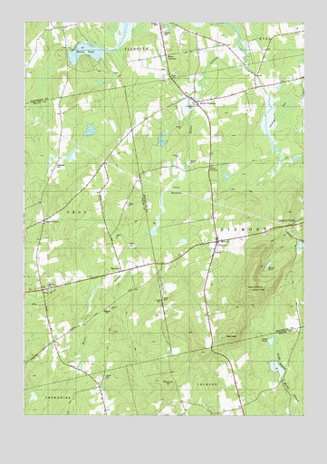
Dixmont, ME USGS Topographic Map
Click on map above to begin viewing in our Map Viewer.

This topographic map contains these locations and features:
Feature Name Type Latitude Longitude GNIS ID View Map
Cates MeadowsSwampN44.6953°W69.1781°563691View Map
Common HillSummitN44.6345°W69.1854°564259View Map
DixmontPopulated PlaceN44.6803°W69.1628°565134View Map
Dixmont Corner CemeteryCemeteryN44.6829°W69.1427°2726968View Map
Dixmont Corner ChurchChurchN44.6806°W69.1617°1913459View Map
Dixmont Post OfficePost OfficeN44.6812°W69.1601°1913460View Map
Dixmont Volunteer Fire Department North StationBuildingN44.7270°W69.1781°2553071View Map
Dixmont Volunteer Main Fire StationBuildingN44.6777°W69.1651°2552752View Map
Drake PondLakeN44.6488°W69.1393°565272View Map
East TroyPopulated PlaceN44.6706°W69.2056°579283View Map
Garfield SchoolSchoolN44.7201°W69.1670°566707View Map
Hathaway CemeteryCemeteryN44.7042°W69.2357°567760View Map
Hows CornersLocaleN44.7395°W69.1859°568407View Map
Huise CornersLocaleN44.7042°W69.1667°568445View Map
Jewel CemeteryCemeteryN44.6614°W69.1870°568818View Map
Mount HarrisSummitN44.6655°W69.1479°567692View Map
Mount Holly CemeteryCemeteryN44.6656°W69.2392°571766View Map
North DixmontPopulated PlaceN44.7251°W69.1728°579563View Map
North Dixmont CemeteryCemeteryN44.7270°W69.1775°2736932View Map
Rogers CornersLocaleN44.6870°W69.2403°574423View Map
Rollins MillsPopulated PlaceN44.7295°W69.1456°579663View Map
Round PondLakeN44.7403°W69.2229°574507View Map
Sawyer CemeteryCemeteryN44.7468°W69.1884°574961View Map
Skinner BogSwampN44.7201°W69.1370°575525View Map
Town of DixmontCivilN44.6957°W69.1333°582444View Map
TroyPopulated PlaceN44.6648°W69.2409°579777View Map
Webster CemeteryCemeteryN44.6592°W69.2124°577956View Map

Note: Coordinates in the location and feature list above are referenced to NAD83 datum.


Copyright (C) 2008-2025 Ryan Niemi / Sunset Dynamics ... All Rights Reserved