TopoQuest Logo
Do you find TopoQuest useful?
Help keep TopoQuest running and adding new maps/features by donating!
Bitcoin:  19c7KJd3qBynnjoSw5npx9KScwjBe4ifkT
Litecoin:  LXs6TkuXGGXo1vDsWCkWVdjQX94eUKd6ui
Home View Maps Find Maps Find Places Resources & Links


Buckeye, Louisiana Topographic Map

USGS Map Title: Buckeye, LA
USGS Map MRC: 31092C2
DRG (GeoTIFF) Download: o31092c2.tif


Neighboring USGS Topographic Map Quads:


  Green Gables, LA  
31092D3
 

  Holloway, LA  
31092D2
 

  Buckeye NE, LA  
31092D1
 

  Libuse, LA  
31092C3
 

  Buckeye, LA  
31092C2
 

  Powell Point, LA  
31092C1
 

  Latanier, LA  
31092B3
 

  Effie, LA  
31092B2
 

  Marksville North, LA  
31092B1


Map MRC Location:

N32°
W93°
N32°
W92°
H8 H7 H6 H5 H4 H3 H2 H1
G8 G7 G6 G5 G4 G3 G2 G1
F8 F7 F6 F5 F4 F3 F2 F1
E8 E7 E6 E5 E4 E3 E2 E1
D8 D7 D6 D5 D4 D3 D2 D1
C8 C7 C6 C5 C4 C3 C2 C1
B8 B7 B6 B5 B4 B3 B2 B1
A8 A7 A6 A5 A4 A3 A2 A1
N31°
W93°
N31°
W92°

Buckeye, LA USGS 1:24K Topographic Map Preview:
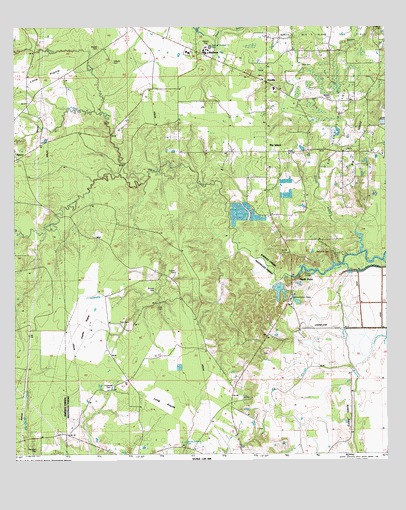
Buckeye, LA USGS Topographic Map
Click on map above to begin viewing in our Map Viewer.

This topographic map contains these locations and features:
Feature Name Type Latitude Longitude GNIS ID View Map
BarronPopulated PlaceN31.3368°W92.2496°542955View Map
Barron Chapel (historical)ChurchN31.3368°W92.2468°551665View Map
Bayou PrairieStreamN31.3043°W92.1390°555720View Map
Big Creek ChurchChurchN31.3171°W92.1624°533068View Map
Big IslandPopulated PlaceN31.3371°W92.1654°542990View Map
Big IslandIslandN31.3424°W92.1340°533084View Map
Big Island Baptist ChurchChurchN31.3368°W92.1574°551673View Map
Big Island ChurchChurchN31.3516°W92.1446°533086View Map
Big Island Oil FieldOilfieldN31.3443°W92.1421°533088View Map
Big Island School (historical)SchoolN31.3516°W92.1349°551674View Map
Big SloughStreamN31.2755°W92.1374°533109View Map
Bradford CemeteryCemeteryN31.3730°W92.1260°533361View Map
BuckeyePopulated PlaceN31.3663°W92.1890°533502View Map
Buckeye Elementary SchoolSchoolN31.3663°W92.1915°2462782View Map
Buckeye High SchoolSchoolN31.3660°W92.1860°551678View Map
Buckeye Post OfficePost OfficeN31.3635°W92.1818°1631713View Map
Burlew CemeteryCemeteryN31.3521°W92.1443°533560View Map
Cainey BayouStreamN31.3082°W92.1335°533613View Map
Camel Church (historical)ChurchN31.2513°W92.2424°551824View Map
Campbell CemeteryCemeteryN31.2516°W92.2429°533667View Map
Center Point Census Designated PlaceCensusN31.2524°W92.2099°2586673View Map
Center Point ChurchChurchN31.2807°W92.1854°533848View Map
Charlotte School (historical)SchoolN31.3527°W92.2393°551686View Map
Cole CemeteryCemeteryN31.2921°W92.2021°534032View Map
Coles IslandIslandN31.2619°W92.1382°534041View Map
DevillePopulated PlaceN31.3574°W92.1654°543143View Map
Deville Census Designated PlaceCensusN31.3399°W92.1389°2402408View Map
Deville ChurchChurchN31.3743°W92.1560°534514View Map
Deville Post OfficePost OfficeN31.3589°W92.1655°1631722View Map
Dyson CreekStreamN31.3488°W92.2207°554307View Map
Guillory CemeteryCemeteryN31.3024°W92.1960°535442View Map
Guillory School (historical)SchoolN31.2860°W92.1879°545521View Map
Haines CreekStreamN31.3307°W92.2146°535486View Map
Harmony ChurchChurchN31.3516°W92.1349°551715View Map
Hayden R Lawrence Middle SchoolSchoolN31.3660°W92.1906°2462758View Map
Hillside ChurchChurchN31.2505°W92.1732°535675View Map
Holloway ChurchChurchN31.3749°W92.2121°535717View Map
Hopewell CemeteryCemeteryN31.2688°W92.2187°535786View Map
Hopewell ChurchChurchN31.2677°W92.2082°554755View Map
Horsepen CreekStreamN31.3310°W92.2146°554759View Map
Island BayouLakeN31.3640°W92.1455°535953View Map
Little PrairieFlatN31.3593°W92.2396°536593View Map
Long PrairieFlatN31.2649°W92.2010°536710View Map
Louisiana Noname 51 DamDamN31.2985°W92.1568°556892View Map
New Hope Free Methodist ChurchChurchN31.3374°W92.1379°555475View Map
Newell CemeteryCemeteryN31.3674°W92.2215°537658View Map
Newell Church (historical)ChurchN31.3671°W92.2201°551747View Map
North PointPopulated PlaceN31.3002°W92.1549°543536View Map
Parish Governing Authority District CCivilN31.3314°W92.2421°1930308View Map
Paul CemeteryCemeteryN31.3624°W92.1537°538022View Map
Richey ChurchChurchN31.2794°W92.1674°538590View Map
Slocum CemeteryCemeteryN31.2977°W92.2029°539418View Map
Smith CemeteryCemeteryN31.3074°W92.1604°539437View Map
Tyler CemeteryCemeteryN31.2882°W92.2110°540074View Map
Union ChurchChurchN31.3513°W92.2451°540091View Map
United ChurchChurchN31.3480°W92.1946°540117View Map
Vasher PrairieFlatN31.2869°W92.2265°540143View Map
Ward OneCivilN31.2552°W92.1526°544910View Map
Wiley Point School (historical)SchoolN31.3260°W92.1599°551801View Map
Wileys PointCapeN31.3049°W92.1621°551802View Map
Woodson CemeteryCemeteryN31.3082°W92.1465°540534View Map
World Harvest TabernacleChurchN31.3288°W92.1610°540540View Map

Note: Coordinates in the location and feature list above are referenced to NAD83 datum.


Copyright (C) 2008-2024 Ryan Niemi / Sunset Dynamics ... All Rights Reserved