TopoQuest Logo
Do you find TopoQuest useful?
Help keep TopoQuest running and adding new maps/features by donating!
Bitcoin:  19c7KJd3qBynnjoSw5npx9KScwjBe4ifkT
Litecoin:  LXs6TkuXGGXo1vDsWCkWVdjQX94eUKd6ui
Home View Maps Find Maps Find Places Resources & Links


Buckhorn, Texas Topographic Map

USGS Map Title: Buckhorn, TX
USGS Map MRC: 30096A2
DRG (GeoTIFF) Download: o30096a2.tif


Neighboring USGS Topographic Map Quads:


  Chappell Hill, TX  
30096B3
 

  Daniels, TX  
30096B2
 

  Howth, TX  
30096B1
 

  Kenney, TX  
30096A3
 

  Buckhorn, TX  
30096A2
 

  Hempstead, TX  
30096A1
 

  Bellville, TX  
29096H3
 

  Burleigh, TX  
29096H2
 

  Sunny Side, TX  
29096H1


Map MRC Location:

N31°
W97°
N31°
W96°
H8 H7 H6 H5 H4 H3 H2 H1
G8 G7 G6 G5 G4 G3 G2 G1
F8 F7 F6 F5 F4 F3 F2 F1
E8 E7 E6 E5 E4 E3 E2 E1
D8 D7 D6 D5 D4 D3 D2 D1
C8 C7 C6 C5 C4 C3 C2 C1
B8 B7 B6 B5 B4 B3 B2 B1
A8 A7 A6 A5 A4 A3 A2 A1
N30°
W97°
N30°
W96°

Buckhorn, TX USGS 1:24K Topographic Map Preview:
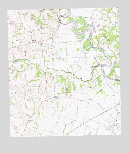
Buckhorn, TX USGS Topographic Map
Click on map above to begin viewing in our Map Viewer.

This topographic map contains these locations and features:
Feature Name Type Latitude Longitude GNIS ID View Map
Apperson CemeteryCemeteryN30.1175°W96.2102°1329631View Map
Arnold LakeReservoirN30.0036°W96.2436°1856990View Map
Arnold Lake DamDamN30.0036°W96.2436°1856989View Map
Browning BranchStreamN30.1116°W96.1905°1331369View Map
BuckhornPopulated PlaceN30.0386°W96.2000°1378063View Map
Caney CreekStreamN30.0702°W96.1466°1332080View Map
Carlisle CemeteryCemeteryN30.1047°W96.2158°1332160View Map
CochranPopulated PlaceN30.0288°W96.1294°1333046View Map
Cochran SchoolSchoolN30.0213°W96.1288°1333050View Map
Dunn LakeReservoirN30.0702°W96.2252°1856988View Map
Dunn Lake DamDamN30.0702°W96.2252°1856987View Map
Eberly Ranch AirportAirportN30.0637°W96.2195°2676557View Map
Frances CemeteryCemeteryN30.0402°W96.1808°1336145View Map
Gibbs CreekStreamN30.0608°W96.1780°1336510View Map
Henson CemeteryCemeteryN30.0513°W96.2214°1337632View Map
Jackson CemeteryCemeteryN30.0344°W96.2072°1338578View Map
Melcher LakeReservoirN30.1035°W96.2445°1865432View Map
Melcher Lake DamDamN30.1036°W96.2452°1865431View Map
Motley CemeteryCemeteryN30.0930°W96.2250°1341995View Map
Perry LakeLakeN30.0696°W96.1263°1343878View Map
Pleasant Grove CemeteryCemeteryN30.0086°W96.1300°1344185View Map
Raccoon BendPopulated PlaceN30.0119°W96.1330°1344692View Map
Saint PaulPopulated PlaceN30.1088°W96.1288°1379006View Map
Samuel ChapelChurchN30.0472°W96.1844°1346290View Map
Sauney ChapelChurchN30.0933°W96.2130°1346723View Map
Sauney StandPopulated PlaceN30.0936°W96.2227°1346724View Map
Smith CemeteryCemeteryN30.0411°W96.1877°1347252View Map
Spring BranchStreamN30.1155°W96.1922°1347689View Map
Staehle CemeteriesCemeteryN30.0477°W96.1611°1347776View Map
Union Center SchoolSchoolN30.0108°W96.1308°1349042View Map
Washam CemeteryCemeteryN30.0358°W96.2002°1349509View Map

Note: Coordinates in the location and feature list above are referenced to NAD83 datum.


Copyright (C) 2008-2024 Ryan Niemi / Sunset Dynamics ... All Rights Reserved