TopoQuest Logo
Do you find TopoQuest useful?
Help keep TopoQuest running and adding new maps/features by donating!
Bitcoin:  19c7KJd3qBynnjoSw5npx9KScwjBe4ifkT
Litecoin:  LXs6TkuXGGXo1vDsWCkWVdjQX94eUKd6ui
Home View Maps Find Maps Find Places Resources & Links


Sunny Side, Texas Topographic Map

USGS Map Title: Sunny Side, TX
USGS Map MRC: 29096H1
DRG (GeoTIFF) Download: o29096h1.tif


Neighboring USGS Topographic Map Quads:


  Buckhorn, TX  
30096A2
 

  Hempstead, TX  
30096A1
 

  Waller, TX  
30095A8
 

  Burleigh, TX  
29096H2
 

  Sunny Side, TX  
29096H1
 

  Hockley Mound, TX  
29095H8
 

  Sealy, TX  
29096G2
 

  San Felipe, TX  
29096G1
 

  Brookshire, TX  
29095G8


Map MRC Location:

N30°
W97°
N30°
W96°
H8 H7 H6 H5 H4 H3 H2 H1
G8 G7 G6 G5 G4 G3 G2 G1
F8 F7 F6 F5 F4 F3 F2 F1
E8 E7 E6 E5 E4 E3 E2 E1
D8 D7 D6 D5 D4 D3 D2 D1
C8 C7 C6 C5 C4 C3 C2 C1
B8 B7 B6 B5 B4 B3 B2 B1
A8 A7 A6 A5 A4 A3 A2 A1
N29°
W97°
N29°
W96°

Sunny Side, TX USGS 1:24K Topographic Map Preview:
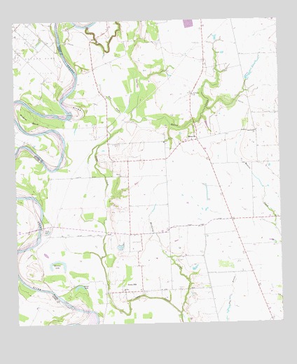
Sunny Side, TX USGS Topographic Map
Click on map above to begin viewing in our Map Viewer.

This topographic map contains these locations and features:
Feature Name Type Latitude Longitude GNIS ID View Map
Beef BayouStreamN29.9522°W96.0797°1351788View Map
Carrington CemeteryCemeteryN29.9008°W96.0497°1353862View Map
Clear CreekStreamN29.9980°W96.0900°1373131View Map
Cunny LakeLakeN29.9133°W96.1102°1355480View Map
Dodd LakeReservoirN29.9768°W96.0142°1862490View Map
Dodd Lake DamDamN29.9786°W96.0119°1862489View Map
Fair Weather FieldAirportN29.9357°W96.0377°2676552View Map
Hannay LakeLakeN29.9011°W96.1056°1358740View Map
Harper CemeteryCemeteryN29.9491°W96.0755°1358823View Map
Harper ChurchChurchN29.9363°W96.0752°1358826View Map
Harris CreekStreamN29.9597°W96.0697°1358847View Map
Harris Creek ChurchChurchN29.9541°W96.0113°1358851View Map
MonavillePopulated PlaceN29.9508°W96.0388°1363046View Map
Monaville CemeteryCemeteryN29.9505°W96.0533°1363047View Map
Monaville Volunteer Fire Department Station 2BuildingN29.9512°W96.0377°2552459View Map
Mount Zion CemeteryCemeteryN29.8880°W96.0661°1363332View Map
Mount Zion ChurchChurchN29.8891°W96.0750°1363345View Map
Mount Zion Community Fire Fighting AssociationBuildingN29.8932°W96.0670°2552633View Map
Mulberry CreekStreamN29.8794°W96.0483°1363442View Map
Palmer LakeLakeN29.8911°W96.0955°1364721View Map
Pea Patch AirportAirportN29.9391°W96.0597°1386805View Map
President CemeteryCemeteryN29.8886°W96.0486°1365756View Map
Saint Thomas CemeteryCemeteryN29.9913°W96.0555°1367324View Map
Saint Thomas ChurchChurchN29.9694°W96.0402°1367327View Map
Sunny SidePopulated PlaceN29.8886°W96.0691°1369403View Map
Sunny Side Post Office (historical)Post OfficeN29.9094°W96.0661°1380627View Map
Vesley CemeteryCemeteryN29.9041°W96.0369°1370625View Map
Waller County Emergency Medical ServicesBuildingN29.9512°W96.0377°2655782View Map
Wildcat BendBendN29.9597°W96.1180°1371510View Map

Note: Coordinates in the location and feature list above are referenced to NAD83 datum.


Copyright (C) 2008-2025 Ryan Niemi / Sunset Dynamics ... All Rights Reserved