TopoQuest Logo
Do you find TopoQuest useful?
Help keep TopoQuest running and adding new maps/features by donating!
Bitcoin:  19c7KJd3qBynnjoSw5npx9KScwjBe4ifkT
Litecoin:  LXs6TkuXGGXo1vDsWCkWVdjQX94eUKd6ui
Home View Maps Find Maps Find Places Resources & Links


Markesan, Wisconsin Topographic Map

USGS Map Title: Markesan, WI
USGS Map MRC: 43088F8
DRG (GeoTIFF) Download: o43088f8.tif


Neighboring USGS Topographic Map Quads:


  Princeton East, WI  
43089G1
 

  Green Lake, WI  
43088G8
 

  Ripon, WI  
43088G7
 

  Manchester, WI  
43089F1
 

  Markesan, WI  
43088F8
 

  Brandon, WI  
43088F7
 

  Randolph, WI  
43089E1
 

  Fox Lake, WI  
43088E8
 

  Buckhorn Corner, WI  
43088E7


Map MRC Location:

N44°
W89°
N44°
W88°
H8 H7 H6 H5 H4 H3 H2 H1
G8 G7 G6 G5 G4 G3 G2 G1
F8 F7 F6 F5 F4 F3 F2 F1
E8 E7 E6 E5 E4 E3 E2 E1
D8 D7 D6 D5 D4 D3 D2 D1
C8 C7 C6 C5 C4 C3 C2 C1
B8 B7 B6 B5 B4 B3 B2 B1
A8 A7 A6 A5 A4 A3 A2 A1
N43°
W89°
N43°
W88°

Markesan, WI USGS 1:24K Topographic Map Preview:
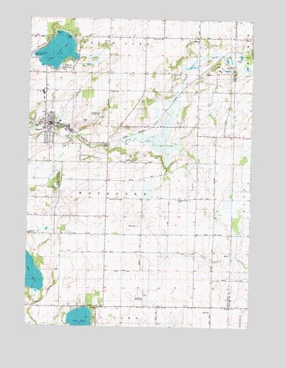
Markesan, WI USGS Topographic Map
Click on map above to begin viewing in our Map Viewer.

This topographic map contains these locations and features:
Feature Name Type Latitude Longitude GNIS ID View Map
Bosveld Brothers Landing Strip (historical)AirportN43.6378°W88.9340°1843721View Map
Broeder QuarryMineN43.6925°W88.9628°2633473View Map
City of MarkesanCivilN43.7098°W88.9907°1583659View Map
County Line ChurchChurchN43.6328°W88.9268°1563454View Map
Del Monte Corporation Landing Strip (historical)AirportN43.7111°W88.9659°1843726View Map
Evergreen School (historical)SchoolN43.7016°W88.9571°1564776View Map
Grand River Fire District - Markesan Fire DepartmentBuildingN43.7160°W88.9914°2697834View Map
Keartys BayBayN43.7439°W88.9840°1843752View Map
Kelley CemeteryCemeteryN43.6314°W88.8970°1565714View Map
Lake EmilyLakeN43.6272°W88.9688°1564623View Map
Lake Emily School (historical)SchoolN43.6325°W88.9601°1567734View Map
Little Green LakeLakeN43.7368°W88.9846°1568269View Map
Lonely Cedar School (historical)SchoolN43.6692°W88.9848°1568519View Map
Mackford Prairie SchoolSchoolN43.6767°W88.9354°1570698View Map
Mackford Prairie School (historical)SchoolN43.6553°W88.9071°1568871View Map
Mackford Union CemeteryCemeteryN43.6772°W88.9182°1568872View Map
MarkesanPopulated PlaceN43.7072°W88.9901°1569051View Map
Markesan City Government Fire DepartmentBuildingN43.7159°W88.9914°2697577View Map
Markesan Elementary SchoolSchoolN43.7051°W88.9914°2716191View Map
Markesan High SchoolSchoolN43.7121°W88.9874°1843756View Map
Markesan Middle / High SchoolSchoolN43.7120°W88.9874°2716276View Map
Markesan Police DepartmentBuildingN43.7056°W88.9868°2759443View Map
Markesan Primary SchoolSchoolN43.7051°W88.9914°2716692View Map
Markesan Wastewater Treatment FacilityLocaleN43.7036°W88.9972°2709430View Map
Memorial CemeteryCemeteryN43.7035°W88.9946°1843759View Map
Muskie BayBayN43.7350°W88.9954°1843760View Map
North Mackford School (historical)SchoolN43.7275°W88.9365°1570463View Map
Prairie View SchoolSchoolN43.7422°W88.9262°1571900View Map
Rogers Memorial State Habitat PreserveParkN43.6844°W88.9834°1843773View Map
Saint Johns Lutheran ChurchChurchN43.7100°W88.9887°1843777View Map
Soldiers-Sailors ParkParkN43.7300°W88.9823°1843812View Map
Southern Green Lake County Ambulance ServiceBuildingN43.7159°W88.9912°2698303View Map
Sunny Hillside School (historical)SchoolN43.6880°W88.9057°1575084View Map
Tichora CemeteryCemeteryN43.7208°W88.9554°1575439View Map
Town of MackfordCivilN43.6747°W88.9428°1583620View Map
UtleyPopulated PlaceN43.7275°W88.9062°1577869View Map

Note: Coordinates in the location and feature list above are referenced to NAD83 datum.


Copyright (C) 2008-2025 Ryan Niemi / Sunset Dynamics ... All Rights Reserved