TopoQuest Logo
Do you find TopoQuest useful?
Help keep TopoQuest running and adding new maps/features by donating!
Bitcoin:  19c7KJd3qBynnjoSw5npx9KScwjBe4ifkT
Litecoin:  LXs6TkuXGGXo1vDsWCkWVdjQX94eUKd6ui
Home View Maps Find Maps Find Places Resources & Links


Bucktown, Indiana Topographic Map

USGS Map Title: Bucktown, IN
USGS Map MRC: 38087H3
DRG (GeoTIFF) Download: o38087h3.tif


Neighboring USGS Topographic Map Quads:


  Sullivan, IN  
39087A4
 

  Dugger, IN  
39087A3
 

  Linton, IN  
39087A2
 

  Carlisle, IN  
38087H4
 

  Bucktown, IN  
38087H3
 

  Sandborn, IN  
38087H2
 

  Oaktown, IN  
38087G4
 

  Bicknell, IN  
38087G3
 

  Plainville, IN  
38087G2


Map MRC Location:

N39°
W88°
N39°
W87°
H8 H7 H6 H5 H4 H3 H2 H1
G8 G7 G6 G5 G4 G3 G2 G1
F8 F7 F6 F5 F4 F3 F2 F1
E8 E7 E6 E5 E4 E3 E2 E1
D8 D7 D6 D5 D4 D3 D2 D1
C8 C7 C6 C5 C4 C3 C2 C1
B8 B7 B6 B5 B4 B3 B2 B1
A8 A7 A6 A5 A4 A3 A2 A1
N38°
W88°
N38°
W87°

Bucktown, IN USGS 1:24K Topographic Map Preview:
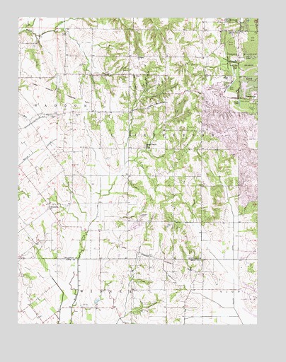
Bucktown, IN USGS Topographic Map
Click on map above to begin viewing in our Map Viewer.

This topographic map contains these locations and features:
Feature Name Type Latitude Longitude GNIS ID View Map
Benefiel CemeteryCemeteryN38.9600°W87.3453°430803View Map
Bethany ChurchChurchN38.9839°W87.3131°430870View Map
Bethlehem ChurchChurchN38.9220°W87.3586°430979View Map
BucktownPopulated PlaceN38.9948°W87.2600°431756View Map
Harper CemeteryCemeteryN38.9598°W87.3581°435763View Map
Indian Prairie ChurchChurchN38.9473°W87.3081°436779View Map
Kixmiller QuarryMineN38.9156°W87.3114°2649528View Map
Land CemeteryCemeteryN38.9927°W87.3503°437597View Map
McDade CemeteryCemeteryN38.9761°W87.2670°438848View Map
More LakeLakeN38.9793°W87.2540°439423View Map
Motorboat LakeLakeN38.9752°W87.2644°439506View Map
Mount Moriah ChurchChurchN38.9987°W87.2597°439607View Map
Mount Zion ChurchChurchN38.9767°W87.3153°439757View Map
PleasantvillePopulated PlaceN38.9670°W87.2503°441356View Map
Pleasantville - Jefferson Township Volunteer Fire DepartmentBuildingN38.9674°W87.2520°2626002View Map
Pollard DitchCanalN38.8756°W87.2578°441412View Map
Posey CemeteryCemeteryN38.9911°W87.2970°441475View Map
Red LakeLakeN38.9830°W87.2567°441822View Map
Skidmore CemeteryCemeteryN38.9806°W87.3436°443574View Map
South LakeLakeN38.9636°W87.2601°443825View Map
Township of JeffersonCivilN38.9659°W87.2837°453498View Map
Trimble CemeteryCemeteryN38.9766°W87.3303°444885View Map
Twin LakeLakeN38.9775°W87.2619°445015View Map

Note: Coordinates in the location and feature list above are referenced to NAD83 datum.


Copyright (C) 2008-2025 Ryan Niemi / Sunset Dynamics ... All Rights Reserved